Storms moving through the central United States left a trail of weather warnings across Kansas and the Upper Midwest late Monday as forecasters warned that a huge swath of the country from Texas to the Great Lakes could be in for several days of severe weather this week.
There were no immediate reports of widespread damage in Kansas. Another set of storms prompted tornado watches across parts of Iowa, Minnesota and Wisconsin, where forecasters were investigating reports of tornadoes and hail. Green Bay, Wis., was under a flash flood warning until late Monday night.
In Michigan, the authorities were increasingly concerned about rising water levels at the Cheboygan Dam near Lake Huron. Gov. Gretchen Whitmer declared a state of emergency on Friday as melting snow and heavy rain sent water levels rising at the dam. And on Monday, the Cheboygan County sheriff’s office warned residents to be prepared to evacuate. More rain was expected in the area overnight into Tuesday.
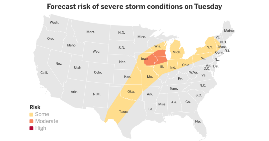
Tuesday is expected to bring additional storms, which are likely to begin in the afternoon and continue overnight in some areas. Chicago, Des Moines and Milwaukee are in the bull’s-eye of a warning map that stretches from southwestern Texas to New England, putting nearly 70 million people at risk for some hazards as the storms move through.
More storms are expected across the same areas on Wednesday. Thursday is likely to offer a brief reprieve, forecasters said, before storms pick up again on Friday.
The severe weather threat is typical for this time of year, said Jared Guyer, a meteorologist at the Storm Prediction Center. It is being fueled by a steady supply of warm, moist air from the Gulf of Mexico, combined with a daily parade of weather systems moving across the country.
How to prepare
Nazaneen Ghaffar is a Times reporter on the Weather team.
The post Storms Leave a Trail of Warnings Across the Midwest appeared first on New York Times.