On the Florida peninsula, this time of year is typically pretty dry.
The hurricane season is winding down, and the warm, tropical atmospheric conditions that can bring daily downpours throughout the summer are moving on, replaced by lower humidity and far less rain during the late fall and winter.
But this is not a typical year.
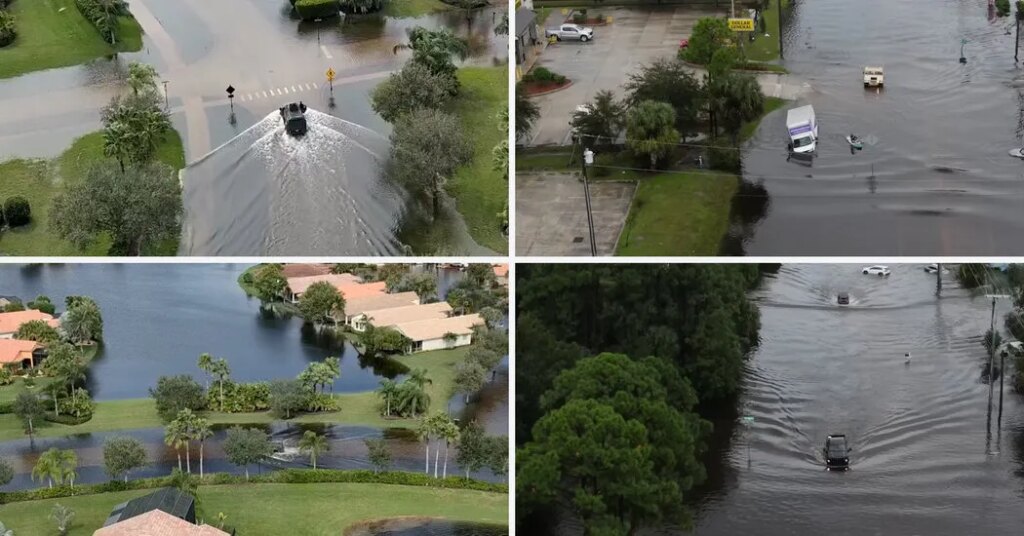
This week, relentless rain caused by a series of storms between Sunday and Tuesday led to flooding that inundated homes, submerged roads and left some neighborhoods inaccessible. Federal officials said the weather on Sunday was “certainly a factor” in the Learjet crash that left nine people dead outside Palm Beach.
The National Weather Service gauge in the city of Melbourne, southeast of Orlando, records an average of about two and a half inches of rain in November. On Monday alone, the site measured 11.51 inches, recording its highest amount in a single day, surpassing the 10.23 inches that fell during Hurricane Irma on Sept. 10, 2017. What’s more, three days into the month, the site had already recorded its wettest November ever, with 13.69 inches of rain, eclipsing the 9.72 inches set in November 1963.
Elsewhere in Brevard County, including the town of Malabar, some gauges recorded more than two feet of rain this week.
Meteorologists said that the unusually heavy rain was a prelude to the stormy weather that is expected this winter because of El Niño, a climate pattern that scrambles weather worldwide. In Florida, that scrambling will probably make this winter a very damp one, experts said.
“I think this is a good indication of what we can expect this year,” said Emily Powell, Florida’s state climatologist. “Although I will caveat that with the fact that no two El Ninõs look the same.”
Dr. Powell said the strength of El Niño this year and its footprint in the Pacific Ocean, which sets the stage for much of El Niño’s effects around the world, are similar to the winter of 1997-98, another El Niño winter that brought more storms than usual to the state.
The storms can bring all types of severe weather that are less likely in a typical Florida winter, including heavy rain. Statewide, Florida typically averages about eight inches of rain during the winter. But during the 1997-98 El Niño winter, the state received more than 20 inches, nearly 230 percent of its normal rainfall.
There’s also a higher chance of tornadoes. “There is an almost 50 percent increase in tornado watches in parts of the Florida peninsula in a strong El Ninõs winter compared to other years,” said Evan Bentley, a warning coordination meteorologist at the Weather Service’s Storm Prediction Center.
In February 1998, more than 40 people were killed during a tornado outbreak in Central Florida, among the deadliest in state history.
Dr. Powell and other experts cautioned that it was not possible to draw a direct line straight from El Niño to any individual storm, including this week’s rain. Instead, think of El Niño as making certain kinds of weather more likely. “It’s probabilistic,” Mr. Bentley said. “It’s like having the deck stacked in your favor, but it doesn’t necessarily mean the next card is going to be an ace.”
Other atmospheric conditions can still come along and take over, heightening or weakening El Niño’s overall effect in a given place day to day. Still, Dr. Powell said, meteorologists’ ability to predict what El Niño will do in Florida is “especially strong.”
In an El Niño winter, the jet stream, the bands of air currents high in the atmosphere that control where the weather goes, tends to send storm systems straight to the Florida peninsula, she said.
“And so what that means is, those typical impacts — bearing an El Niño would include, wetter weather, slightly cooler temperatures, increased cloud cover and increased storminess — those tend to play out here in Florida,” she said.
It is not uncommon for Florida storms to rapidly blossom into the upper reaches of the atmosphere, according to David Roth, a meteorologist with the Weather Service.
What made this week’s rain unusual, he said, was not just that it arrived at the start of the dry season, but how sprawling the heaviest rain was.
Some places were recording six inches of rain an hour. When rain falls at that rate, it’s “absolutely blinding,” said Robert Haley, a meteorologist with the Weather Service office in Melbourne.
“You feel like you’re swimming,” he said.
Judson Jones contributed reporting.
The post Florida Shattered Rain Records This Week. Was That Just a Preview? appeared first on New York Times.