The punishing heat wave that made most of last week nearly unbearable across the New York City area is finally over. But over the weekend a rash of sporadic and dangerous storms hit the tristate area and continued into Monday, leading to torrential rain, flash flooding and wind speeds reaching up to 90 miles per hour.
The high winds hit Connecticut especially hard, with towns and cities declaring states of emergency from its northern to southern borders.
“The last time I saw a storm like this was the ice storm in 2011,” said Molly Spino, the mayor of Torrington, a city in northwestern Connecticut. At one point on Sunday, 30 roads were impassable in the city, and half of its residents had lost power, she said. There were no serious injuries. “We were very lucky,” she said.
In parts of Orange County, N.Y., northwest of New York City, up to eight inches of rain was reported as of 10 a.m. Monday, and basements flooded in several towns, the National Weather Service said.
By Monday morning, parts of New Jersey were inundated with storm waters. In Oakhurst near the Jersey Shore, part of the roof at a BJ’s Wholesale Club collapsed late Monday morning. Two people were partially trapped but able to free themselves, and no one was injured, the Monmouth County sheriff’s office said. A few miles south in Neptune, the Jersey Shore University Medical Center also flooded.
Portions of Route 35, a state highway, were flooded in the Oakhurst area, submerging multiple vehicles and requiring some rescues. And by the early afternoon, a local Jersey Shore road popular with tourists, Ocean Avenue, had started to flood.
As climate change makes summers hotter, the atmosphere can hold more moisture, which can lead to heavier rainfall and unpredictable storms, scientists have said.
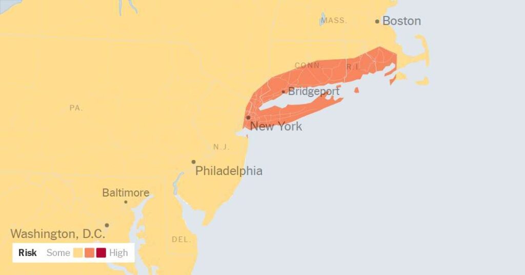
For the rest of Monday, the National Weather Service will be monitoring northern and coastal New Jersey through southeast New York, including the New York City area, Long Island, southern Connecticut, southern Rhode Island and parts of southeast Massachusetts. On Monday, the National Weather Service issued a flash flood warning for southern Brooklyn, Queens and Long Island until about 3:30 p.m.
Storms in this corridor may repeatedly move over the same places, a pattern known as “training,” which can quickly lead to high rainfall. About three to six inches of rain, are possible, with isolated areas potentially seeing eight inches of rainfall or more, the service said.
On Monday, many towns across the New York region were still cleaning up after storms on Saturday night tore through many Fourth of July celebrations.
From Gowanus, Brooklyn, to Brookfield, Conn., trees were uprooted, some becoming entangled with live electrical wires, which slowed down power restoration. On Saturday night in Brookfield, a boater on Candlewood Lake nearly lost his life, he said, because of the high winds, which all but destroyed the docking area. And downed 50-foot-tall trees in the area came dangerously close to hitting an older couple’s home, taking out their power, too.
Despite the destruction, there were no serious injuries or fatalities in Connecticut, officials said on Monday.
After strong winds brought down power lines and tree limbs, nearly 200,000 homes and businesses across New York, New Jersey, Connecticut and Pennsylvania were still without power on Monday morning, according to poweroutage.us, which tracks data from utility companies.
High winds occur when there are clashes of different, rapidly changing temperatures, said James Connolly, a meteorologist for the National Weather Service.
In Southern Connecticut, nearly 13,000 residents in Fairfield County alone are still without power. Lexi Paquette, a spokeswoman for Connecticut’s Division of Emergency Management and Homeland Security, said power should be restored by the end of Monday or Tuesday morning.
Additional crews from Canada arrived to help local utilities restore service, which could be out for days in some areas, Ned Lamont, Connecticut’s governor, said on Sunday.
Several major highways were partially closed because of downed trees entangled with electrical wires, including two major thoroughfares in the coastal town of Fairfield.
Ms. Paquette said the additional storms throughout Monday, which carry a flash flood risk, could hamper efforts to restore power.
On Sunday night, as forecasters watched the weather system’s ingredients come together west of New York, they were still uncertain where, exactly, the worst of the rain would fall.
Ultimately, it fell, but not in copious amounts.
“New York City dodged a bullet,” Mr. Connolly said. But it is not out of the woods, and commuters should prepare for a potentially messy journey on Monday afternoon, he warned.
The New York area could still see up to two inches of rain per hour. “Please — take this weather seriously,” Mayor Zohran Mamdani of New York said on Sunday.
Gov. Kathy Hochul said state agencies had been mobilized to respond to any flooding.
When significant rain falls very quickly, areas such as basements, subways and low-lying streets can flood within minutes.
Parts of Pennsylvania and Ohio received several inches of rain as of early Monday, and some flooding was occurring. The Weather Service office in State College, Pa., said that some of the heaviest rainfall totals reached around five inches, particularly east of Harrisburg, where 5.32 inches was recorded in Hummelstown.
By Monday afternoon, the weather had caused departure delays of about 45 minutes at the three major airports serving New York City.
The rain should taper off by Tuesday morning, the National Weather Service said.
Patrick McGeehan contributed reporting.
The post After Brutal Heat, Tristate Area Bombarded With Heavy Wind and Rain appeared first on New York Times.