Large parts of the Western United States are expected to face their most critical wildfire risk so far this season over the next few days.
Utah, where multiple fires were already burning on Wednesday and filling skies with smoke, was at the center of an area where forecasters were most concerned about the potential for large wildfires to expand. But the threat is widespread, extending into Arizona, Nevada, Idaho, Wyoming, Colorado and New Mexico, with fire watches and red flag warnings in place to alert people that fires could spark more easily than usual and spread more quickly once they start.
-
Wednesday and Thursday: Scattered thunderstorms in the afternoon and evening could bring rain, which can reduce the risk of fire — but also lightning strikes and bursts of wind, which can increase it.
-
Friday and Saturday: Dry, breezy weather will arrive, which could spread fires more easily.
While wildfires can occur at any time in the West, June is the start of a more active season that runs through October. This week, meteorologists have watched closely as the end of the school year and the arrival of summer have sent more people outdoors to take part in the types of activities that can lead to wildfires — such as gathering around campfires.
The West is vast, and the wildfire risk varies broadly across the region from day to day. This week, forecasters’ fiercest concern was focused over Utah and nearby states.
The overall risk in California was relatively low, where the vegetation hasn’t fully dried out, though the threat there was expected to rise on Friday and into Saturday. The fire risk was also elevated over Oregon and Washington on Wednesday and Thursday, though the threat will drop by Friday and through the weekend with rain on the way.
Thunderstorms bring rain, but also lightning.
Summer is also monsoon season across the Southwest, when the seasonal weather pattern pushes moisture across the region. These storms can wet the landscape, and even cause flooding in some areas. But they also bring abundant lightning — even in areas that get no rain, a phenomenon called dry lightning.
In Utah, an area that includes Salt Lake City and Provo was at the highest risk for dry thunderstorms on Wednesday, according to the Storm Prediction Center. On Thursday, the storms are expected to be wetter and focused across the Colorado Plateau into southwestern Wyoming and far eastern Idaho.
When lightning occurs under a blanket of moist air, the strikes can start what are known as holdover fires, which may not start out as very active. When conditions turn drier, as they are expected to become on Friday and Saturday, the fires that were quietly smoldering in the ground can burst into life.
“A holdover fire may start but not fully emerge until a few days later,” said Lexy Elizalde-Garcia, the lead fire forecaster at the Storm Prediction Center.
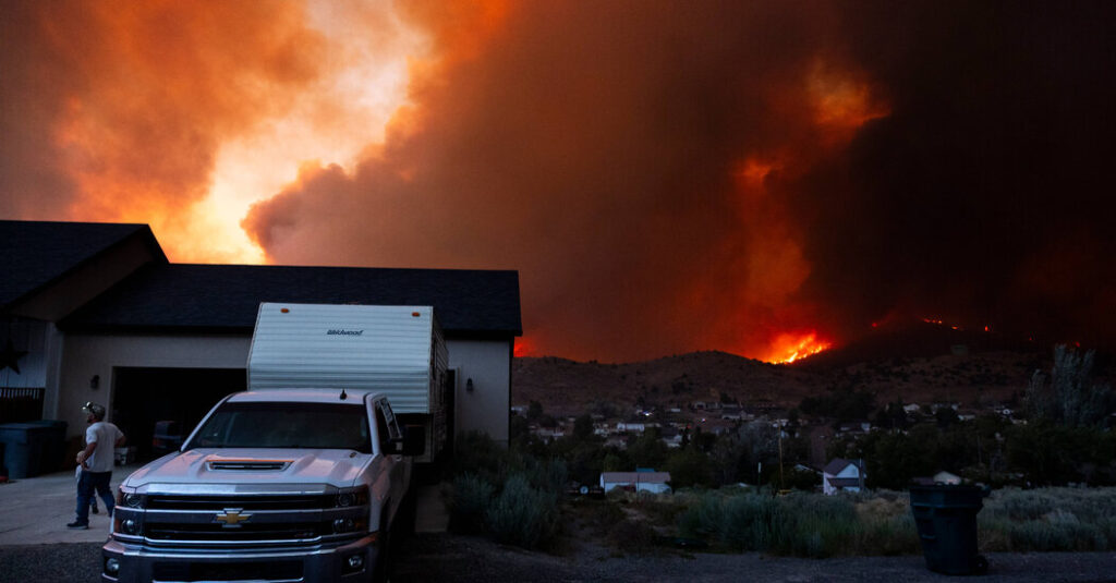
Multiple wildfires were already burning across that area on Wednesday, particularly in Utah. The Iron fire, 80 miles south of Salt Lake City near the small city of Eureka, has burned more than 31,000 acres since it began on Friday. To the south, the Cottonwood fire had ballooned to 59,000 acres by Wednesday afternoon and set off evacuations across Beaver and Piute counties.
Like every other state in the West, Utah recorded historically low amounts of snow last winter, resulting in drier conditions this spring and summer that have left the landscape parched and highly flammable.
“The conditions we’re seeing right now, we usually we don’t see until mid-July to August,” said Karl Hunt, a spokesman for the Utah department that oversees forestry and wildfires.
The fires have pumped out a lot of smoke, and the view of the mountains from Salt Lake City on Wednesday was shrouded by a blanket of acrid air. The smoke, which reached as far as Colorado, has reduced air quality across the region, but it could also keep thunderstorms from spreading as much as they might without it.
Friday was expected to bring the start of a dry, breezy pattern that will spread across the region and continue into Saturday as a cold front passes. Any fires that start could spread quickly with these high winds. Humidity levels were also predicted to drop, and the air will feel very dry.
“All that moisture from Wednesday and Thursday will move east into the Central Plains, and then we get that hair dryer effect where it will be hot, dry and windy,” Ms. Elizalde-Garcia said.
The post Western Wildfire Risk This Week Is the Highest It’s Been So Far This Year appeared first on New York Times.