For all the concerns about a historic El Niño fueling epic storms striking California this winter, there is still a surprising amount of debate among experts about how bad it will actually be.
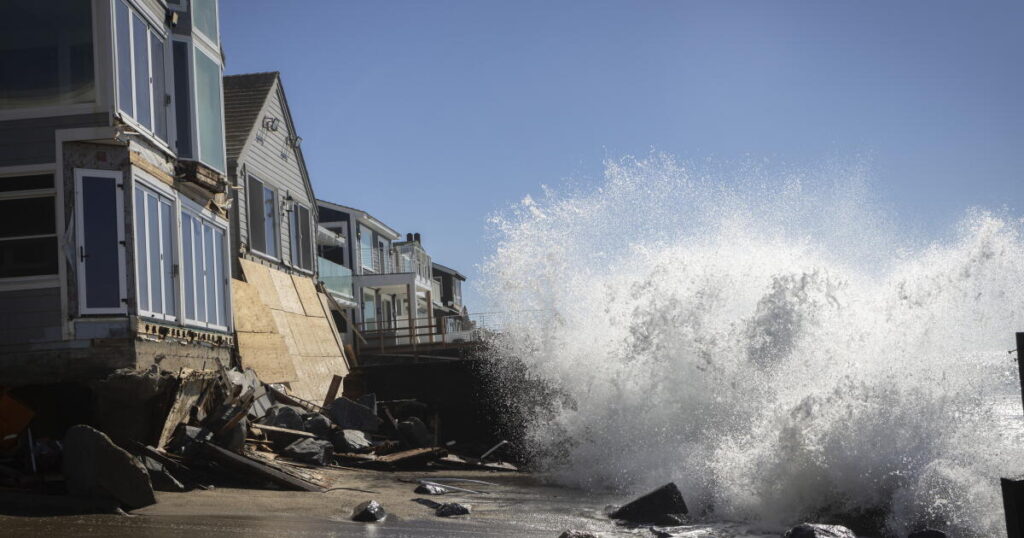
Scientists are highly confident about the risk of coastal seawater flooding and beach erosion — fueled by rising sea levels and strong surf — with king tides coming around Thanksgiving, Christmas and Martin Luther King Jr. Day.
But when it comes to predicting the power of winter storms, there is far less consensus.
Officially, confidence of that is tempered, and some are emphasizing a wide range of possible outcomes. “We only have more moderate confidence, at best, of … freshwater flooding, debris flows associated with if we do see some of that heavier storm activity across Southern California,” said Robbie Munroe, meteorologist with the National Weather Service in Oxnard.
The official seasonal precipitation outlook issued by the National Oceanic and Atmospheric Administration says that Southern California has a 60% to 70% chance of above-normal precipitation for January, February and March. “But that still leaves about a 30% to 40% chance of near- or below-normal precipitation, and so this winter is not a slam dunk in terms of how the overall season will occur,” Munroe said.
Three of the last four winters brought Southern California above-normal rain, and only one of them coincided with an El Niño. “So even if we see above-normal precipitation, it doesn’t mean it’s going to be much different than what we’ve seen recently,” Munroe added.
“The big El Niño is setting the stage,” said Julie Kalansky, deputy director for the Center for Western Weather and Water Extremes at UC San Diego. “El Niño doesn’t really dictate the outcome, but it really kind of tilts the odds for a wetter winter, especially in Southern California.”
Others are placing greater emphasis on reasons this winter could be one for the record books, in terms of rain.
Much of coastal California could get nearly double the average precipitation for January, February and March, especially in Southern California, the San Francisco Bay Area and the Central Coast, according to UC Agriculture and Natural Resources climate scientist Daniel Swain.
That’s according to the ensemble mean — or average — of the European Center for Medium-Range Weather Forecasts’ SEAS 5.1 model, which issues ocean and atmosphere predictions months in advance.
A reasonable worse-case scenario involves seeing more than two-and-a-half times the average precipitation, Swain said. And that’s a scenario state and local emergency planners should prepare for, he added.
Rain and snow is forecast to return to California starting by Friday, and “I do expect that we’re going to start to see some significant wet storms by December, especially from about the San Francisco Bay Area southward,” Swain said. “Right now, it is looking like January and February are the most likely months to have big-time rain and potential flood concerns.”
In fact, “the odds of a winter that’s at least among the top 10 wettest we’ve ever seen is really high,” Swain said. In addition, “along the entire California coast, there’s probably at least a 10% chance of a record wet winter, and the odds in a typical year of a record wet winter would be less than 1%.”
El Niño-fueled weather has already battered the California coast this year, causing flooding from San Diego to Marin County, damaging scores of homes and other structures and eroding coastal cliffs. But exactly how it will play out this winter is still coming into focus. In early 1983, a powerful El Niño coincided with a historically memorable storm season, badly damaging piers and flooding numerous homes. But the most recent powerful El Niño season, in 2015-16, defied expectations, and the winter was relatively dry for Southern California (although the coast did see record erosion).
El Niño is a climate pattern marked by warmer ocean waters in the central and eastern equatorial Pacific Ocean, near Peru and Ecuador, which spur changes in the atmosphere that can affect weather around the world. El Niño is typically, but not always, associated with a wetter-than-average winter in Southern California.
On Thursday, the National Weather Service’s Climate Prediction Center said that El Niño is continuing to strengthen, with temperatures continuing to increase on the sea surface. There is virtually a 100% chance that this El Niño will be classified as “very strong,” and there’s a 60% chance that this El Niño will be the strongest on record since modern recordkeeping began in 1950.
Some experts caution that very strong El Niños aren’t a 100% bet on massive floods for California. “Everyone sees El Niño — they think massive flooding everywhere. Well, we know from 2015-16 … it was a different setup, but it was still El Niño, and, you know, the south coast of California had 77% of normal rainfall,” said meteorologist Jan Null, an adjunct professor at San José State University.
People should certainly be prepared for more rainfall than normal, Null said, but the intensity of the destructive power depends on “the spacing of that rain throughout the winter.”
Swain noted that predictive models are now different than what was available ahead of the 2015-16 El Niño season, and there are new factors at play this year, noting the intense rains that recently flooded swaths of the Four Corners region of Arizona, New Mexico, Utah and Colorado. “We’ve never seen oceans this warm before. We’ve never seen the atmosphere this warm before. We’ve never seen this much atmospheric water vapor in the air.”
“All of that tells us that I really do think we need to be on guard in a place like California for the potential for very heavy precipitation and subsequent inland flood risk this winter. The coastal flood risk,” Swain added, “is already here and it’s getting worse.”
Indeed, all-time sea level records were broken in October across Southern California — in San Pedro, Santa Barbara, San Diego Bay and La Jolla. Not only are we seeing unusually high astronomical tides (because we’re near the peaks of what are known as the 18.6-year lunar node tidal cycle and the 4.4-year lunar perigee tidal cycle), but the record hot ocean water off the California coast is causing sea levels to rise, since hotter water takes up more volume.
All that ocean heat, which is influenced by El Niño and human-caused global warming, has pushed up the average sea level in Southern California to about 16 inches higher than would be ordinarily expected by astronomical forces alone. That’s way higher than any past record during an El Niño.
“We have never seen anything like this in terms of the degree of elevation of sea level on a sustained basis at this time of year in coastal Southern California. This is truly extraordinary,” Swain said.
When king tides approach over the Thanksgiving holiday week, the astronomical tides alone will be between half a foot to 1 foot higher than they were at the end of October, Swain said, depending on the location. On top of that, there’s also the impact of winter storms and hotter ocean temperatures, raising sea levels further.
That means total sea levels could be 2 to 3 feet higher than the recent record peaks in late October, Swain said, “if a moderate or stronger storm aligns with the peak king tides.”
Swain has been candid about criticism he’s received about his messaging, which has accused him of fearmongering, and that, essentially, “El Niño doesn’t mean anything for California. It can be wet. It can be dry.”
“What I’m doing here is not scaring the pants off of people just for the sake of being dramatic,” Swain said. “But,” he added, “when there is a remarkable signal for something that is potentially a very big deal … I’m going to say so clearly, and this is me doing that now.”
A series of storms was set to hit California as early as Friday and last through early next week. Through Saturday, between one-quarter to 1 inch of rain will be common across Southern California, and there is a small chance for thunderstorms for the coast. High surf is expected, possibly enough to cause pier damage, especially over the weekend on the Central Coast, the National Weather Service said.
The post Fearmongering or fair warning? A fierce debate over how bad California’s El Niño winter will get appeared first on Los Angeles Times.