The first round of severe storms pushed through the Plains on Thursday, during what was expected to be an active weekend for severe weather.
More than 1 million people were included in a Level 3 out of 5 risk zone from NOAA’s Storm Prediction Center, with Omaha, Nebraska, in the bull’s-eye.
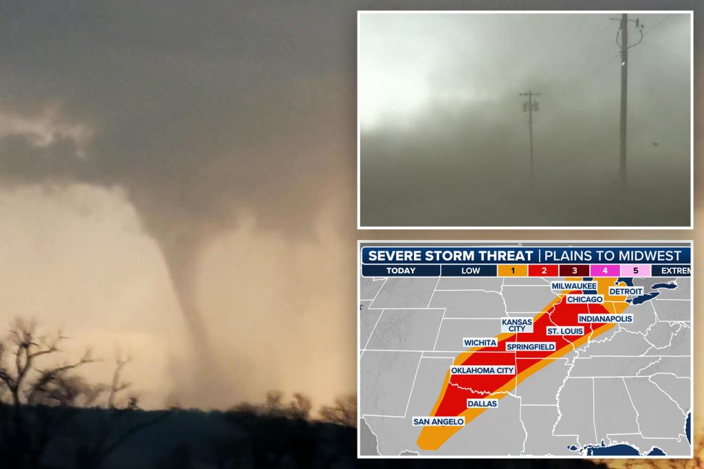
While the city proper missed out on seeing the strongest of the storms, it didn’t prevent warning sirens from blaring on the north side of the city, and tornadoes from being spotted in nearby Iowa.
Several storm chasers, including FOX Weather Storm Tracker Brandon Copic, captured video of a tornado forming then rolling across the fields of Missouri Valley, Iowa, on Thursday evening.
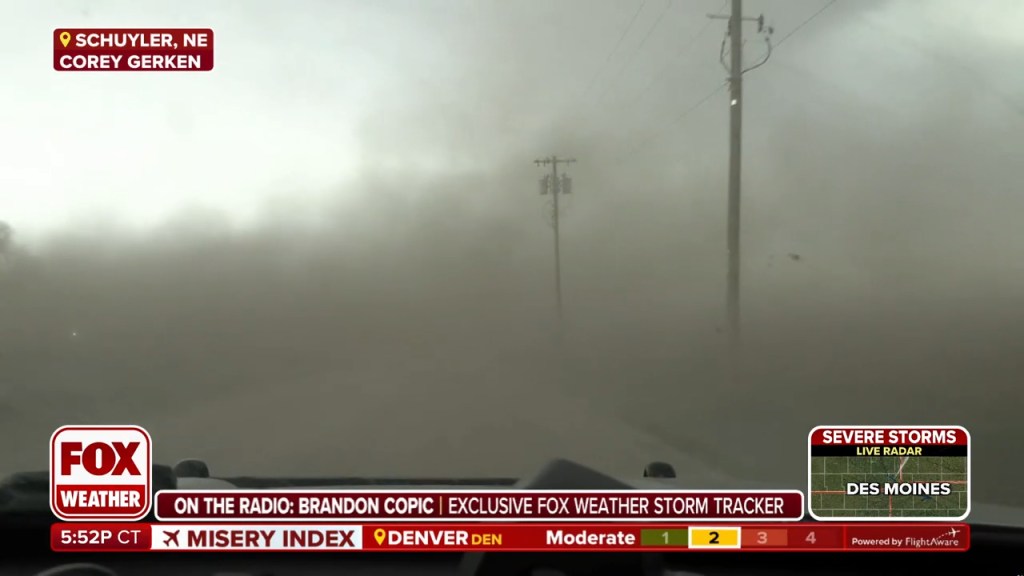
In eastern Nebraska, winds of greater than 80 mph and baseball-sized hail caused what appeared to resemble a dust storm or even a gustnado around Schuyler, Nebraska.
The region was under various alerts at the time, and FOX Weather Exclusive Storm Trackers Corey Gerken and Brandon Copic captured the scenes on video.
The dust was so thick, it reduced visibilities outside of Omaha and made travel treacherous.
Despite the scenes, there were no reports of any widespread damage and reported power outages generally stayed below a few thousand customers.
Based on radar data, the storms appeared to be big hailers, with significant values of vertically integrated liquid, indicating the potential for damaging ice.
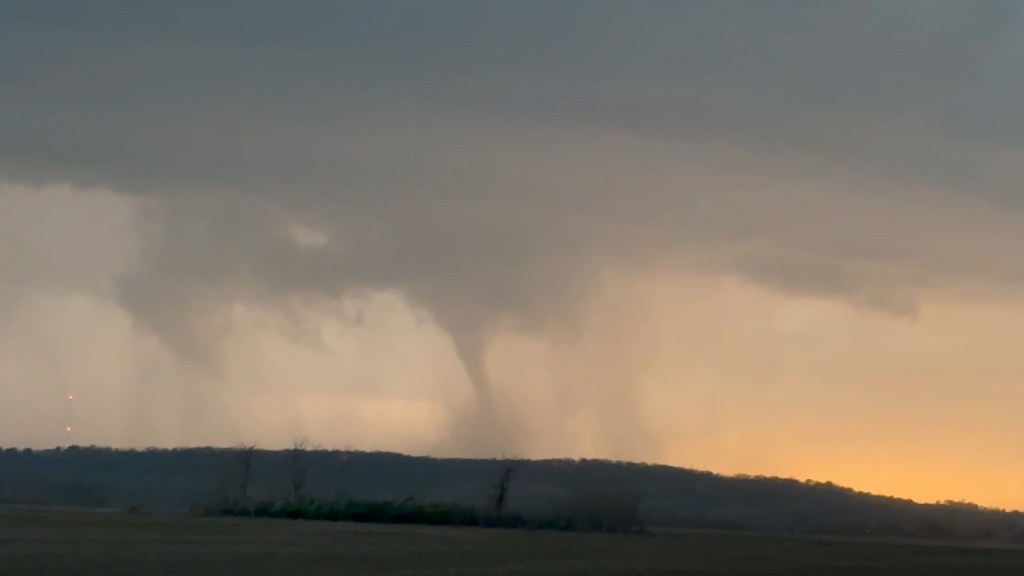
The threat of tornadoes continued well into the night with a large twister spotted around Tabor, Iowa, after sunset.
Videos and Doppler radar indicated that a strong tornado passed through Fremont County, and the National Weather Service office even described the event as a ‘particularly dangerous situation.’
The NWS upped the alert to a rare Tornado Emergency and said the twister was heading towards the town of Essex, Iowa.
The supercell impacted communities over dozens of miles, but because of nightfall, storm chasers and local officials were limited in determining the immediate scope of the damage.
Storm spotters described the tornado as being cone-to-wedge-shaped, but they too were limited to observing the vortex during time periods only when lightning illuminated the sky.
Hundreds of customers were reported to be without power around Essex as power poles were snapped and debris littered some roadways.
First responders were seen gathering on Thursday evening, preparing to go into search and rescue mode for any potential victims trapped in debris.
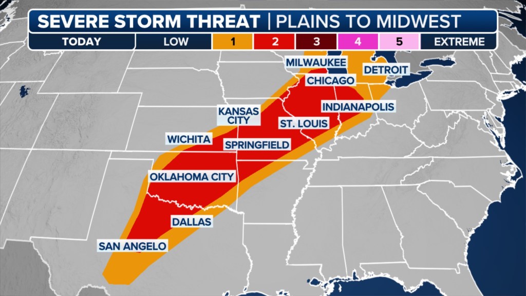
By Friday, the threat of severe weather will shift east and expand from the southern Plains into the Great Lakes region. Numerous thunderstorms are expected to develop in the afternoon and evening.
The FOX Forecast Center said the environment will support a broad area of severe storms, potentially affecting a large area extending from Detroit to Chicago southwestward to Kansas City, Missouri; Oklahoma City, Oklahoma; and northwest of the Dallas-Fort Worth Metroplex in Texas.
These storms will primarily pack a damaging wind and large hail threat. The tornado risk, while not zero, will be low due to a lack of individual supercells. Instead, clusters of storms will develop along the cold front.
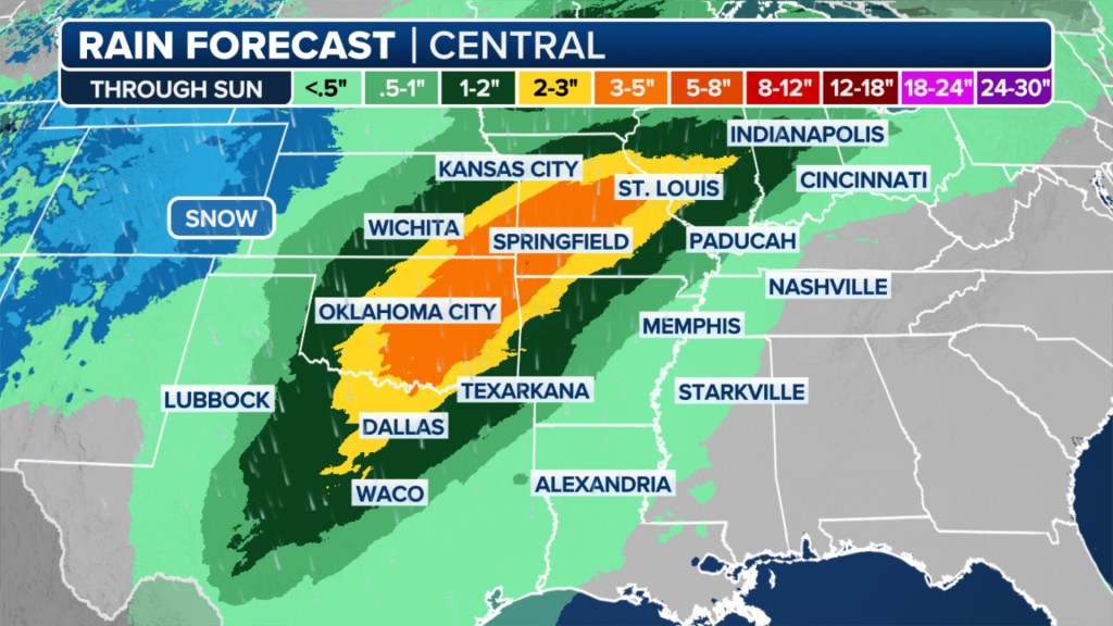
Saturday will see the severe storm threat area shift only a bit. Scattered severe storms seem possible from central Texas into the Ohio Valley on Saturday afternoon and evening. This will also signal the beginning of heavy rain and possible flooding as storms repeatedly drench the same areas, the FOX Forecast Center said.
Across Texas, including the Dallas-Fort Worth Metroplex, the forecast is a little more uncertain due to the presence of morning thunderstorms. These morning storms could “eat up” the available energy in the atmosphere and limit activity later in the day. Should the storms develop, damaging wind gusts of up to 60 mph and hail are the main concerns. A tornado or two can’t be ruled out.
Easter Sunday will be a day to watch as ingredients may come together for a more formidable severe weather event, including more tornadoes.
A region that has been hit very hard by severe weather over the past month may be in the crosshairs: portions of the southern Plains, lower and mid-Mississippi Valley and mid-South region.
Details will become clear as Easter Sunday draws closer. Stay with FOX Weather for the latest developments.
The post Tornadoes, damaging wind gusts blast Plains before severe weather shifts east for Easter weekend appeared first on New York Post.


