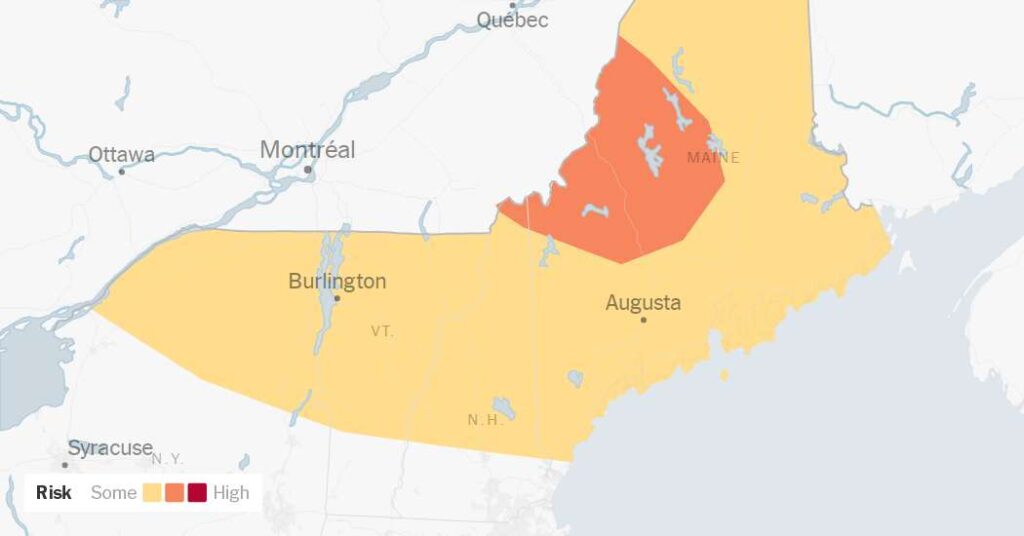
Weather authorities in Canada and the northeastern United States issued forecasts on Tuesday warning that strong storms later in the day could bring damaging winds, large hail and even tornadoes along the border between the two countries.
“The potential is there to see the kind of tornado that Quebec hasn’t seen in decades,” said Dave Sills, the director of the Northern Tornadoes Project at Western University in London, Ontario.
Strong storms were already active in Ontario on Tuesday morning, following earlier severe weather that brought damaging winds and hail from Quebec into Maine.
“The main event will be later this afternoon into this evening, when we’re expecting really powerful supercell thunderstorms that could generate even violent tornadoes,” Mr. Sills said early Tuesday. “It’s an extreme storm environment that we don’t often see in Canada.”
The threat extends from southeastern Quebec into central Maine. The risk is high enough that the U.S. Storm Prediction Center, an arm of the National Weather Service, is also concerned, Mr. Sills noted. Like Environment Canada, the U.S. forecasting agency has highlighted an area right along the border in northern New York and New England as being one at risk.
While storms could form anywhere from the eastern edge of Lake Ontario to the eastern tip of Maine, the most severe threat is along parts of western and central Maine, provided that the storms maintain their intensity as they cross the border.
The trajectory of the system is what concerns meteorologists most. The watch area includes Montreal and Quebec City, two densely populated urban centers at risk for the worst of the severe weather.
Mr. Sills said he is especially concerned because many do not understand that Quebec can experience tornadoes. Although the United States leads the world with about 1,000 tornadoes annually, and Canada ranks second with about 100, they are rare in this region. As is true in the United States, the majority of Canadian tornadoes strike the Plains.
Vermont averages fewer than one tornado per year, Maine about two, and Quebec and New York about 10 each.
If there’s anything normal, it’s the time of year: July is when these stronger storms tend to occur in this region.
Data from the Northern Tornadoes Project has shown that tornadoes regularly occur farther north in Quebec than previously documented. The issue on Tuesday, however, is that exceptionally strong storms are targeting an area unaccustomed to violent tornadoes.
The severe weather is being driven by a large heat dome over the United States. The boundary between this warm, humid air mass and cooler air to the north provides the atmospheric lift necessary to set off explosive storm growth. As this ridge of heat shifts eastward, it is fueling rare, volatile conditions in a region that seldom sees such extreme winds, hail and tornadoes.
Forecasters in Vermont noted one wild card that could derail the severe weather: wildfire smoke. Smoke particles can absorb solar radiation in the atmosphere, warming that layer and stabilizing the air below, which can prevent storms from bubbling up. Forecast models show a thick plume of Canadian wildfire smoke drifting through the region, already degrading air quality.
“I’m looking at the satellite imagery right now, and there’s definitely a plume of smoke that’s traveling southeast with these storms,” Mr. Sills said on Tuesday morning. “That’s certainly a wild card.”
In years with heavy smoke moving across the continent, his team has observed lower overall counts of both thunderstorms and tornadoes. But satellite imagery on Tuesday also revealed pockets where the smoke was thinning, and it had not stopped initial storms from firing up earlier in the day.
With a significant threat looming over a populated area, Mr. Sills added, “Let’s hope that just dampens things down enough that we don’t see the worst from this environment.”
The post Tornadoes in Maine? A Rare Forecast for Parts of U.S. and Canada appeared first on New York Times.