Storms moving through the central part of the United States on Tuesday brought with them the potential for damaging winds and a few tornadoes, and the National Weather Service warned of a particularly high risk of what it called “giant” hail around Dallas.
The forecast was the latest in a nearly weeklong sequence of stormy days in the region. On Monday, a man died in Michigan when a tree fell on him amid high winds, and severe storms brought down trees and power lines in the Midwest.
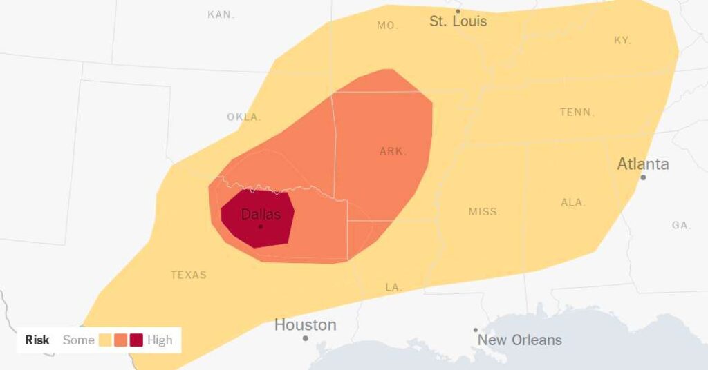
The threat on Tuesday was focused over portions of the Midwest, Southern Plains and Southeast, where a tornado watch covered a broad area from North Texas to West Tennessee and northern Alabama. By early Tuesday afternoon, a few brief tornado warnings had been issued, but there were no immediate reports of damage.
Forecasters were especially focused on an area of North Texas, where they warned that hail as large as a softball could fall from the sky on Tuesday afternoon and evening.
“Hail that size can shatter a window,” said Allison Prater, a meteorologist with the Weather Service office in Fort Worth.
Judge Clay Jenkins of Dallas County, the top elected official there, told residents on social media to have several ways of receiving weather alerts on Tuesday.
“This afternoon and evening have the chance to be VERY active for severe weather,” Judge Jenkins wrote on social media. “All hazards are possible.”
Several rounds of thunderstorms are expected into the evening, bringing a risk of damaging winds, large hail, heavy rain and a few tornadoes. Some could intensify into highly organized, long-lived supercell thunderstorms.
Thunderstorms are fueled by rapidly rising columns of warm, moist air known as updrafts. The updraft lasts about 30 minutes or less in a typical thunderstorm and can endure for over an hour in a supercell. Giant hail is most often a product of a supercell.
The thunderstorm threat on Tuesday ranged from a Level 1 to 3 out of 5 across a broad area of the Southern Plains and Southeast, but in the afternoon, forecasters bumped Dallas up to a Level 4.
“The main concern with the storms today in that area is the potential for very large hail and that’s what drove that upgrade in the risk category,” said Harry Weinman, a meteorologist with the Storm Prediction Center. “We also have concern for damaging winds, and we can’t rule out tornadoes as well.”
Quieter weather is expected after Tuesday. While there is still a chance for severe storms on Wednesday, the risk level is much lower than it has been in recent days.
Jesus Jiménez contributed reporting.
Amy Graff is a Times reporter covering weather, wildfires and earthquakes.
The post Very Large Hail Expected in Dallas as Severe Storms Sweep the South appeared first on New York Times.