After days of sitting under a blanket of wildfire smoke, the Northeast on Saturday was being hit by thunderstorms that were flushing out the acrid air but also threatening the area with strong winds, heavy rains and even possible tornadoes.
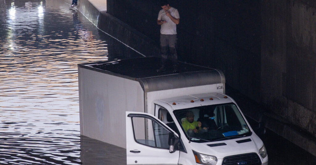
Through the day, winds knocked over trees, and downpours flooded roadways. Rain pounded New Jersey and New York City in the afternoon, leading to dramatic images of people caught driving in floodwaters, including a person standing on top of a box truck that became partially submerged under a Brooklyn-Queens Expressway overpass.
More than 55 million people were threatened by the severe weather in an area that spread from Cleveland to New York City to Washington. Tens of thousands of customers in Virginia and Maryland were without power on Saturday evening, according to PowerOutage.us.
Forecasters with the National Weather Service said that more storms were likely Saturday night and that the biggest concern with these was winds over 70 miles per hour, and that there was also a small chance for tornadoes. Tornado watches were in effect into Saturday evening across a broad area including southeast Pennsylvania and much of Delaware, Maryland and New Jersey.
New York City was expected to get additional rounds of thunderstorms Saturday night, with storms likely moving through before 8 p.m. and then maybe again around 11 p.m.
The storms brought scattered heavy rain and isolated flooding across the Ohio Valley into the Mid-Atlantic States and southern New England, with New York City, Newark and Philadelphia among the cities particularly threatened. The flooding risk continued into the evening.
A flurry of flood watches, severe thunderstorm watches and tornado watches were issued Saturday across parts of the Mid-Atlantic, and forecasters said people could keep an eye out for more urgent warnings. While a watch is a heads-up that conditions are favorable for hazardous weather, a warning is an order to take immediate action.
“The worst of it is in Brooklyn and Queens, where we got over two inches of rain,” said Bill Goodman, a meteorologist with the Weather Service office in Upton, N.Y.
The New York Fire Department said that rescue operations took place for people trapped in their cars citywide. According to the Police Department, at least three major roadways were temporarily closed in sections in Brooklyn and Queens.
New York City Emergency Management warned that rainfall rates had “exceeded what the sewer system can drain” in some places on Saturday. With more rain expected, the agency said, people living in basement apartments and homes prone to flooding should be ready to move to higher floors.
The area just north of Baltimore to New York City was likely to see the most severe storms, said Brian Hurley, a meteorologist with the Weather Prediction Center. These storms could bring damaging winds to some areas, but not all of these areas will be hit by the strongest winds.
Mr. Hurley said it was difficult to pinpoint exactly where the most hazardous weather would occur. Thunderstorms are tricky to forecast, and they can suddenly form, darkening clear skies and bringing heavy bursts of rain, strong winds and lightning.
Claire Fahy contributed reporting.
The post Thunderstorms, Flooding and Strong Winds Sweep the Northeast appeared first on New York Times.