DNYUZ
No Result
View All Result
DNYUZ
No Result
View All Result
DNYUZ
Home News

30 million across the Heartland, Northeast face renewed flood threat as rounds of rain sweep across regions

July 9, 2026
in News
30 million across the Heartland, Northeast face renewed flood threat as rounds of rain sweep across regions

Following early-week storms and flash flood threats across the Upper Midwest, heavy rainfall will gradually shift out of the region as a cold front pushes southeast.

By the end of the week, this front will become the focus for increasing showers and thunderstorms from the Heartland, as well as the Northeast.

This slow-moving front brings a resurgence of rain and flood risks to 30 million Americans.

Recently, some of these areas across the Ohio and Tennessee valleys have been slammed—and this system is set to target communities where soils are already completely saturated from recent torrential downpours at the end of June.

The front will continue to move southeast as stronger southerly flow develops ahead of it, with storm coverage expected to increase across the Mississippi Valley on Thursday before expanding into the Ohio and Tennessee Valleys on Friday. 

Abundant moisture and high instability ahead of the front will support multiple rounds of heavy rain-producing thunderstorms through Sunday.

Winds running parallel to the front will allow storms to repeatedly develop and move over the same locations, increasing the potential for training thunderstorms and excessive rainfall. 

Aerial view from a helicopter showing flooded farmland and houses.
Flooding and heavy rain in the Cumberland area of Kentucky. Kentucky State Police

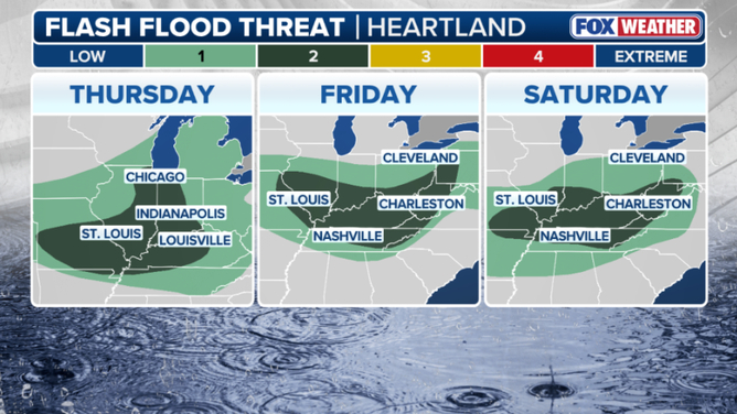
As a result, a level 2 out of 4 flash flood threat is in place on Thursday across portions of the Mississippi River Valley, including Western Kentucky, southern Illinois, and parts of eastern Missouri.

By Friday, the threat shifts just ever so slightly to the east, where a Level 2 flash flood risk is once again in place from Friday through early Sunday across portions of southwestern Pennsylvania, Ohio, Kentucky, Missouri, Tennessee, and West Virginia. 

According to the FOX Forecast Center, the threat into Friday could be upgraded to a Level 3 out of 4 if the forecast holds for slow-moving storms tracking over the same areas.

A black car and an ATV sit partially submerged in floodwaters in Wayne County, Kentucky.
Following early-week storms and flash flood threats across the Upper Midwest, heavy rainfall will gradually shift out of the region as a cold front pushes southeast. Wayne County Rescue Squad
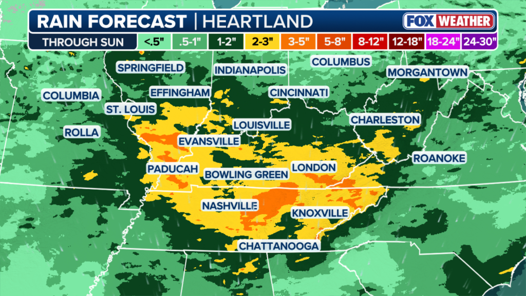
Illustration of a rain forecast map for the Heartland region, showing varying rain accumulation levels through Sunday, with the heaviest rainfall (3-5 inches, represented in orange) concentrated over Kentucky and Tennessee, including cities like Bowling Green, Nashville, and Knoxville.
This slow-moving front brings a resurgence of rain and flood risks to 30 million Americans. FOX Weather

Flash flood threats will extend into next week as the front continues to sag slowly south and east.

Widespread rainfall totals of 1 to 2 inches are expected from southern and central Missouri eastward into West Virginia and northern Tennessee, with up to 3 inches possible across southern Indiana, Kentucky, and Tennessee.

Beyond widespread totals, localized amounts exceeding 3 to 5 inches are possible where storms repeatedly track over the same areas. 

Weather forecast maps for Thursday, Friday, and Saturday showing flash flood threats across the Heartland region, with varying levels of intensity in different cities.
FOX Forecast Center, the threat into Friday could be upgraded to a Level 3 out of 4 if the forecast holds for slow-moving storms tracking over the same areas. FOX Weather
Flooding in Wayne County, Kentucky, showing a washed-out road and rushing water.
Flash flood threats will extend into next week as the front continues to sag slowly south and east. Wayne County Rescue Squad

Additionally, with soils already saturated, especially across Kentucky, where Flash Flood Emergencies were issued to the end of June, the risk of flash flooding will be elevated.

While the heaviest and most impactful rainfall is expected across the Ohio and Tennessee Valleys, scattered showers and thunderstorms will also accompany the front across the Northeast through the end of the week—mainly on Friday. 

Behind the front, an area of high pressure will build in, bringing a return to sunny, drier conditions by Saturday evening and Sunday for the Northeast.

The post 30 million across the Heartland, Northeast face renewed flood threat as rounds of rain sweep across regions appeared first on New York Post.


Hochul and Blakeman in Heated Debate on Trump, Mamdani and High Prices
News

Hochul and Blakeman in Heated Debate on Trump, Mamdani and High Prices

by New York Times
October 14, 2026

The New York governor’s race has gotten louder, nastier and more contentious as Election Day nears. And on Tuesday, in ...

Read more
News

Jewish educators told to condemn Israel before attending conference: report

October 14, 2026
News

‘You are rude!’ MAGA rep loses it as constituents laugh at his excuse for gas prices

October 14, 2026
News

Jennifer Meyer and new husband Geoffrey Ogunlesi get handsy on Hawaii beach just hours after tying the knot

October 14, 2026
News

This TV Theme Scared Kids So Much, Parents Wrote Letters Asking NBC to Change It

October 14, 2026
ICE agent threw California homeowner, 72, into side of a car, attacked his daughter, D.A. says

ICE agent threw California homeowner, 72, into side of a car, attacked his daughter, D.A. says

October 14, 2026
Crowd stunned silent as Trump speeds through his affordability routine at Alaska rally

Crowd stunned silent as Trump speeds through his affordability routine at Alaska rally

October 14, 2026
FBI arrests OpenAI employee accused of planting secret recording device in conference room

FBI arrests OpenAI employee accused of planting secret recording device in conference room

October 14, 2026

DNYUZ © 2026

No Result
View All Result

DNYUZ © 2026