For two decades, satellite imagery has been my window into the unreachable.
I’ve used it to expose North Korean oil smuggling and to uncover a mass grave in Burundi. In 2022, the Visual Investigations team at The New York Times used images to rebut Russian claims that the killing of civilians in Bucha, Ukraine, occurred after their soldiers had left. And in the U.S.-Israeli war in Iran, these eyes in the sky have been similarly revealing.
I surveyed the damage in Tehran from space shortly after Israeli strikes hit the compound of Iran’s supreme leader, Ayatollah Ali Khamenei, killing him. Our team tracked the damage that Iranian attacks wrought on regional U.S. bases. An image we captured through a satellite company even helped to determine U.S. responsibility for the strike on an elementary school in Minab, Iran, that killed at least 150 people, many of them children. And just last month, we showed how the United States bombed what appeared to be a drinking-water facility, a strike that if done deliberately could constitute a war crime under international law.
We reported some of these stories despite five U.S. satellite providers cutting off access to high-resolution images of Iran and surrounding countries shortly after the war began. The main reason for these restrictions is that Iran might use the imagery to target U.S. troops. This blackout applies to customers who regularly publish satellite imagery, such as news outlets and think tanks.
I spent the last few months examining these restrictions and exploring workarounds, including tapping into international satellite imagery providers. My work here offers a window into how The Times uses satellite imagery — and how this kind of journalism has been a complicated undertaking for decades, not just in the current war.
A challenge with historical roots
I knew “shutter control,” as this kind of blocking is called, was likely to happen in Iran because it had happened before. In 2001, the United States exclusively purchased all available commercial satellite imagery of Afghanistan, citing the protection and support of its invading troops. Until the late 1990s, high-resolution satellite imagery was exclusive to intelligence agencies and the Pentagon; they had a quality comparable to those on modern Google Maps.
So when commercial imagery emerged, national security provisions were integrated into the private market. A 1992 act of Congress and a 1994 presidential directive established requirements for commercial satellite operators to restrict access to data during times of war or national crisis, at the request of the government. Ongoing regulations effectively allow the government to control the distribution of high-resolution satellite images.
During more recent U.S. operations in Afghanistan, for example, a satellite provider denied The Times permission to publish images even after the incident in question was over. Since 2022, some companies have blocked images taken over Ukraine. They also restricted images of Gaza.
Since the launch of its first satellites in 2013, the U.S. satellite imagery company Planet Labs has championed transparency, human rights and journalism. (The Times is a Planet customer.) Notwithstanding some restrictions during the war in Gaza, it has readily distributed imagery to the media, enabling journalists to document atrocities.
So when Planet imposed restrictions during the Iran war, the company became a lightning rod for frustrated analysts and reporters: It was forced to contend with wider national security implications. Unlike other satellite companies that restricted access, Planet alerted its customers to the loss of imagery.
An adversary could use satellite imagery to target troops on the ground. Since the start of the Iran war, seven U.S. soldiers have been killed in drone and missile attacks on American Gulf bases that Iran monitored using a Chinese satellite it had acquired, according to the Financial Times.
A Planet spokesman told me in a June email that “bipartisan stakeholders and national security experts across multiple branches of the U.S. Government engaged commercial companies regarding the risk of misuse of commercial satellite imagery” during conflict.
On July 1, Planet Labs announced it had restored imagery access for Iran and some neighboring countries. Several locations remain under blackout, including the Iranian islands in the Strait of Hormuz, as well as Israel, Jordan, and most of the Persian Gulf nations.
Legal provisions aside, the U.S. government also has financial leverage over commercial providers: It is not only their regulator but also their largest customer. Over the last five years, the share of Planet’s total revenue coming from the defense and intelligence sector grew from 22 percent to an estimated 59 percent.
Rhiannan Price, co-founder of the nonprofit satellite company Common Space, said that “economic pressure is in some ways greater than the legal pressure has ever been on the current providers because they can’t afford to lose those contracts.”
William B. Adkins, the principal deputy director of the National Reconnaissance Office, the U.S. agency collecting intelligence from space, acknowledged in a March 2026 hearing by the House Armed Services Committee that the government gave “guidelines on what areas are sensitive” to companies.
The Pentagon declined to answer questions about the risk of satellite imagery to U.S. troops, or to discuss potential dangers posed by foreign satellites. In May, the United States imposed sanctions on three Chinese satellite companies, accusing them of providing imagery to Iran.
A broader blackout
I’ve discovered that data restrictions go beyond the Middle East conflicts. Recent imagery of some U.S. military sites have also been withheld from satellite companies’ catalogs.
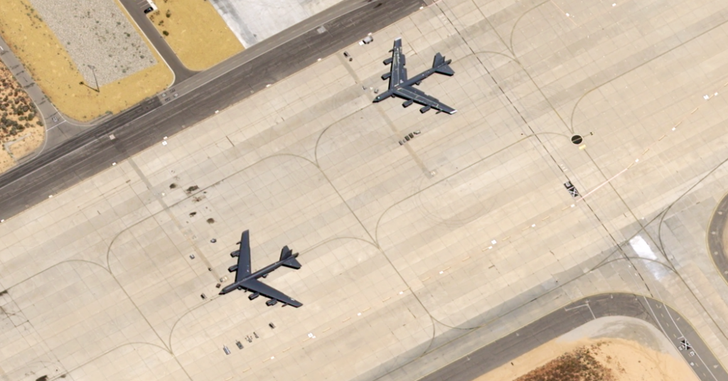
In June, a B-52 bomber crashed during a routine test mission at Edwards Air Force Base in California. As in the Middle East, the latest imagery available for that site from U.S. satellite providers dates back to early March. The Planet spokesman confirmed that images were withheld proactively to reduce possible risks to troops and national security. (Other U.S. satellite image providers permanently restrict sensitive military sites.)
Some firms have restricted locations such as Cypress, Crete, Djibouti and eastern Sudan. Recently, U.S. catalogs were empty when I tried to find an image of a secretive U.S. Special Operations ship in the Island of Diego Garcia, home to a U.S.-British military base. The ship wasn’t involved in the Iran war.
And I’ve noticed that restrictions appear to be going global. When I contacted several Asian companies to acquire high-resolution satellite imagery of conflict-affected areas in the Middle East, two satellite companies based in China denied my requests. A sales manager at one of the companies wrote that they would not “provide sensitive data,” such as images from war zones. It’s unclear why those restrictions were implemented.
Working around shutter control
During the U.S. invasion of Afghanistan in 2001, alternatives to the American providers of high-quality images didn’t exist. But they do now, a fact the U.S. government has sometimes acknowledged by easing some restrictions. To cover the Iran war, The Times has turned to these international providers.
We are able to continue reporting by combining public data — like ship and plane tracking data and online military posts — with imagery from providers in Europe and Asia. For example, I was able to use flight tracking data and a European satellite image to monitor a resupply aircraft and establish that a U.S. base in Djibouti was serving the U.S.S. George H.W. Bush aircraft carrier.
The Times considers any possible security risks, including to soldiers or refugees in active conflict zones, before it publishes imagery. Images we do publish are newsworthy, often coming from conflict or disaster zones that are hard to reach.
The U.S. Office of Space Commerce referred questions about restrictions to the National Oceanic and Atmospheric Administration, which did not respond to The Times.
Imagery is also available through NASA and the European Space Agency. Those scientific organizations collect low-resolution imagery, but it is sufficient to show ships, planes or damaged buildings.
And public access to satellite imagery is approaching a turning point: the launch of satellites by nonprofits and news companies. The German business magazine WirtschaftsWoche is partnering with a company to launch two satellites by 2028. Thomas Stölzel, the magazine’s coordinator for satellite journalism, told me this would allow them to decide for themselves what imagery is most useful.
But for now, despite these workarounds, the restrictions still deny journalists the ability to fully report on the conflict.
The post What U.S. Restrictions on Satellite Imagery Mean for Iran Reporting appeared first on New York Times.