The hottest weather of the summer is about to bake the Washington area.
As dangerous heat expands across the East, the area is under a heat advisory and an excessive heat watch. With high temperatures several degrees above 100 and low temperatures around 80, the stretch from Thursday to Saturday will feature some of D.C.’s hottest days on record.
Temperatures in D.C. are expected to hit 97 degrees on Wednesday, then up to highs of 103 on Thursday and Friday, according to the National Weather Service. Independence Day on Saturday could also breach 100 degrees before a cooldown into early next week.
The National Weather Service also warns of heat index values, a metric used to determine heat risk to the human body, of 103 to 106 degrees, but notes “dangerously hot conditions with heat index values up to 112” are possible late in the week.
If the forecast high temperatures hit their mark later this week, numerous records could be in jeopardy. The standing daily records in D.C. are 101, 101 and 100 degrees, observed in 1898, 1966 and 1919 respectively.
The average temperatures on Friday could range from 91 to 93 degrees.
By this metric, D.C.’s hottest day on record was July 7, 2012, when the high was 105 degrees and the low was 82 degrees — an average of 93.5 degrees.
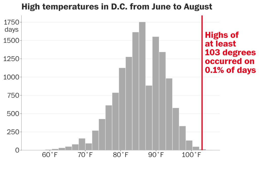
Since temperature records for D.C. began in 1871, there have been only 20 summer days when the temperature has reached or exceeded 103 degrees — putting such heat in the 99.9th percentile.
All this heat is thanks to a heat dome, or sprawling ridge of hot high pressure, that’s nudging into the Mid-Atlantic. It’s centered over Tennessee and Kentucky, and will migrate eastward before flattening and slowly subsiding into the weekend.
Heat domes are like magic force fields in the atmosphere. That means the jet stream, a river of swiftly moving winds in the upper atmosphere, and most storm systems get shunted north into Canada.
Instead, the heat dome just brings hot, sinking air. As the air sinks, it heats up even more.
D.C.’s official temperature readings are taken at Reagan National Airport. Given its placement, any southerly or southwesterly wind would bring in slightly cooler, moister air off the Potomac.
Therefore, even if downtown D.C. hits 100 degrees, the sensor could read closer to 97 or 98 degrees.
To register 100 degrees at National, we generally need a more west-southwesterly or westerly wind that would blow sunbaked and slightly drier air from Crystal City eastward.
As such, it’s possible Thursday may struggle to register 100 degrees at National, but Friday — when the winds turn more westerly — has a solid bet at cracking the triple digits.
The post See the forecast for what could be some of D.C.’s hottest days on record appeared first on Washington Post.