Mexico City is one of the fastest sinking cities in the world. Now, a powerful satellite from the US National Aeronautics and Space Administration (NASA) confirms the accelerated advance of this silent threat that puts nearly 20 million people at risk.
The satellite designed by NASA and the Indian Space Research Organization (ISRO), known as NISAR (NASA-ISRO Synthetic Aperture Radar), was able to capture with unprecedented precision the magnitude and evolution of this phenomenon in different areas of the Mexican capital. The analysis is based on preliminary measurements taken from space between October 2025 and January of this year, during the dry season in Mexico City.
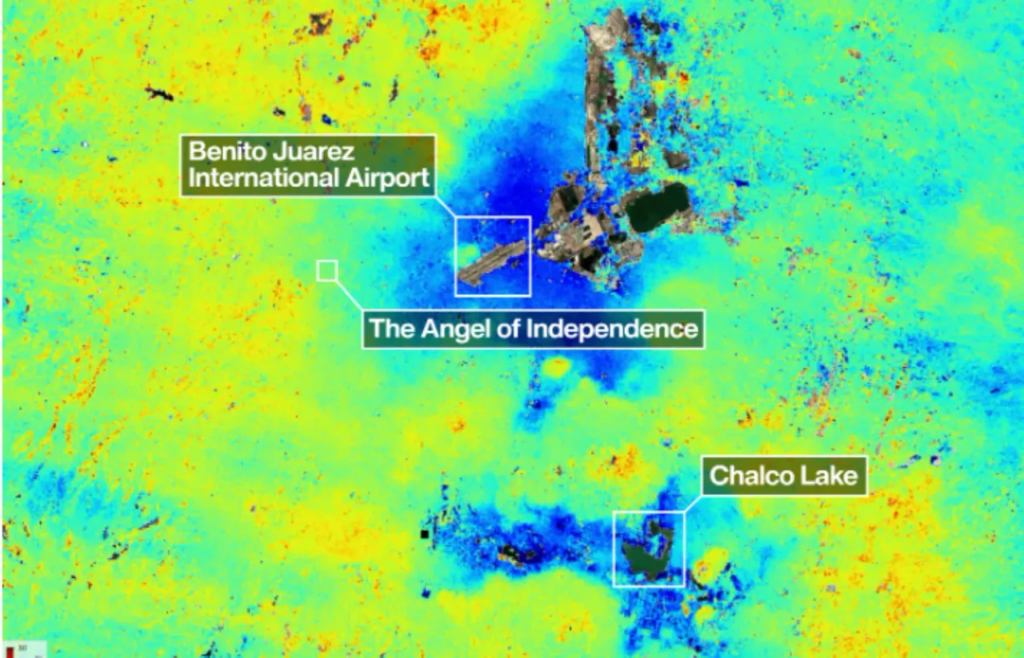
Their findings were captured in a map that shows how the subsurface of the metropolis is shifting. In the map, NASA identified areas with subsidence greater than 2 centimeters per month (marked in dark blue). The agency specifies that the areas marked in yellow and red could correspond to background signals (or noise) that are expected to diminish as the satellite instrument collects more data.
The image also highlights the location of Benito Juarez International Airport, located near Lake Nabor Carrillo, which operates in the middle of an area with accelerated subsidence. “Images like this confirm that the NISAR measurements are in line with expectations,” said Craig Ferguson, deputy director of the project.
X content
Mexico City sits atop the clay and lake bed of ancient Lake Texcoco. NASA explains that this process is a consequence of intense groundwater pumping and the increasing weight associated with urban development. Both factors have caused the compaction of the ancient lake soil for more than a century.
The phenomenon was first documented in 1925 by engineer Roberto Gayol. Between the 1900s and 2000s, some areas experienced a drop of nearly 35 centimeters per year, causing damage to infrastructure such as the Metro, one of the largest mass transit systems in the Americas.
A study conducted in 2024 by Dario Solano-Rojas, a remote-sensing specialist at the National Autonomous University of Mexico, found that subsidence is not uniform. After analyzing changes in the city’s elevation between 2011 and 2020, the researcher and his team concluded that subsidence rates are highly variable: While some areas register up to 50 centimeters per year, in others the phenomenon is almost imperceptible.
This creates “differential subsidence,” where the ground sinks unevenly not only across square kilometers or city blocks, but even on a meter scale. When a street, railway, or building sinks differently at one end compared to the other, its stability is compromised.
NASA‘s findings support this interpretation. The agency warns that “uneven and seemingly small elevation changes have added up over the decades, fracturing roads, buildings, and water lines.”
Accurately and continuously monitoring these terrain variations is fundamental for developing public policies and mitigation strategies. In this regard, NASA has demonstrated that its technology can play a key role.
NASA’s Powerful NISAR Satellite
NISAR is a satellite capable of tracking changes on the Earth’s surface in near real time from orbit, overcoming visibility limitations—such as cloud cover or dense vegetation—that affect optical sensors and some conventional radars.
According to the agency, this instrument—operational since July 2025—is the first to incorporate two synthetic aperture radars (SARs) at different wavelengths, allowing it to monitor Earth’s land and ice surfaces twice every 12 days. It also features a cylindrical reflector antenna, 12 meters wide, which facilitates the collection of highly detailed data.
“Mexico City is a well-known hot spot when it comes to subsidence, and images like this are just the beginning for NISAR. We’re going to see an influx of new discoveries from all over the world, given the unique sensing capabilities of NISAR and its consistent global coverage,” said David Bekaert, project manager at the Flemish Institute for Research in Technology and a member of the science team.
This story first appeared on WIRED en Español and has been translated from Spanish.
The post Mexico City Is Sinking. A Powerful NASA Satellite Just Exposed How Fast appeared first on Wired.