Just weeks after major storms brought snow to the Sierra Nevada mountains, a winter heat wave has all but eliminated California’s snowpack gains.
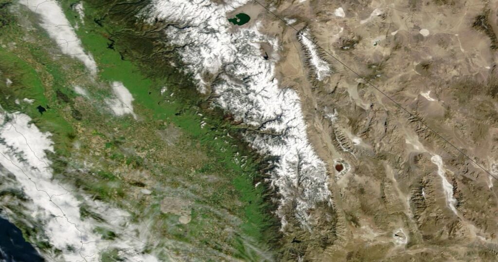
Satellite photos from NASA show the extent of the major melting event, which took place in late February and early March.
“The extremely rapid loss of the snow that fell during the late Feb storm cycle, which in many cases dropped multiple feet of snow in the Sierra Nevada over just a couple of days, is genuinely remarkable,” Daniel Swain, a climate scientist with UC Agriculture and Natural Resources, said in an email to The Times.
The image below shows the Sierra from space on Feb. 22, at left, and then on March 3.
In less than 10 days, the snow receded significantly amid a heat wave that sent temperatures 15 to 20 degrees above normal in much of the state.
As forecasters expect above-average temperatures for the next several weeks, Swain said, snowpack losses are likely to continue.
California relies on the Sierra snowpack for about 30% of its water.
But extreme warmth across the West this winter has meant more precipitation falling as rain, not snow — a symptom of global warming, experts say, which in recent years has been pushing average snow lines higher in the mountains and changing the timing of runoff.
There are 130 monitoring stations across the Sierra Nevada that provide electronic readings of the snowpack. The northern Sierra is currently at 38% of average and the southern Sierra 83% of average. In the image above from Feb. 22, the southern Sierra was at 98% of normal.
The image below shows the Sierra on Feb. 12, left, and again on March 3.
The heavy snow that blanketed the mountains in between the photos was barely noticeable, as snow levels had retreated back to early-February levels.
Swain noted that there is still significant moisture in California’s mountains, but the diminished snowpack will likely affect the state’s water supply and wildfire risk later this summer.
“The very early loss of snowpack will effectively make the long, dry summer that much longer in the mountains,” he said.
Times staff writer Ian James contributed to this report.
The post Satellite photos show California’s sudden snowpack meltdown: Now you see it, now you don’t appeared first on Los Angeles Times.