Hurricane Kiko is moving west over the open waters of the Pacific, according to forecasters, after the system strengthened from a tropical storm on Tuesday.
Why It Matters
Two hurricanes are present in the eastern Pacific as of Wednesday morning, Kiko and Lorena. While Kiko is over open waters, meteorologists have warned that Lorena could bring heavy rain impacts to parts of Mexico and the U.S.
What To Know
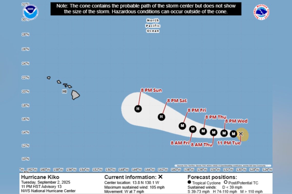
In its most recent update on Kiko, the National Hurricane Center (NHC) said the hurricane was maintaining a Category 2 strength, and was located approximately 1,700 miles east of Hilo, Hawaii.
The agency reported maximum sustained winds nearly 105 mph and that the system was moving west at 7 mph.
“Strengthening is expected during the next day or so, and Kiko is forecast to become a major hurricane on Wednesday,” the NHC said.
Fox Weather reported that while the system was moving in the general direction of the Hawaiian Islands, it was not expected to bring major impacts to land as of Tuesday.
Spaghetti Models at 00z for #Kiko DiscussionThe Spaghetti Models are showing Kiko to stay out in sea and with the Spaghetti Models mostly showing TS to C4 on the SSHWS#wxtwitter #wxX #Tropicalwx #Tropicswx #Tropics #Hurricane #TropicalUpdate #HurricaneKiko #Category2 pic.twitter.com/hcoHZLxuAR
— TrevorTropicsWX (@TrevorTropicsWX) September 3, 2025
Meanwhile, forecasters were also monitoring Hurricane Lorena, after it formed from a tropical storm on Wednesday.
The NHC warned of heavy rains affecting Baja California Sur and southwestern Sonora in Mexico this week, as well as the possibility of heavy rainfall in Arizona from late Wednesday through Friday.
“On the forecast track, the center of Lorena is expected to move parallel to the west coast of the Baja California peninsula today and Thursday and then approach the coast Thursday night and Friday,” it said.
The NHC added: “Rapid strengthening is forecast through tonight. Fast weakening is expected to begin on Thursday, and Lorena could weaken back to a tropical storm by Friday.”
What People Are Saying
AccuWeather lead hurricane expert Alex DaSilva told Newsweek on Tuesday: “There is still a lot of time to watch Kiko. It is certainly possible that the storm could trend north or south of the [Hawaiian] islands and bring little to no direct impacts. There is also the possibility that the storm could bring rain and wind impacts to the islands. As the storm approaches the islands it will move over cooler water which should help to reduce the wind intensity of the storm.
“Regardless, we urge everyone with interests in Hawaii to follow the AccuWeather forecast very closely as small shifts in track can have major implications of the direct impacts felt on the islands.”
Meteorologist Ryan Maue said in a post on X, Monday: “Tropical Storm Kiko in the eastern Pacific well east of Hawaii has formed a nice eye on visible satellite imagery.
“No doubt a hurricane and appears to be rapidly intensifying…earlier models suggested Cat 4 maximum.”
What Happens Next
Regular forecast updates are issued by the NHC on its website and social media channels.
The post Hurricane Kiko Spaghetti Models as Storm Moves in Direction of Hawaii appeared first on Newsweek.