The East Coast is expecting to see impacts from Hurricane Erin next week after the storm rapidly intensifies into a Category 4 hurricane, the strongest storm of the Atlantic hurricane season so far.
The storm became a Category 1 hurricane on Friday morning after slowly strengthening throughout the week.
Why It Matters
As of Friday morning, Erin had maximum sustained windspeeds of 75 miles per hour, making it a Category 1 storm. It’s the first hurricane to form in the Atlantic Ocean this year.
An updated forecast map from AccuWeather shows Erin is expected to reach Category 4 strength by Monday afternoon. A Category 4 hurricane has maximum sustained windspeeds between 130 and 156 mph.
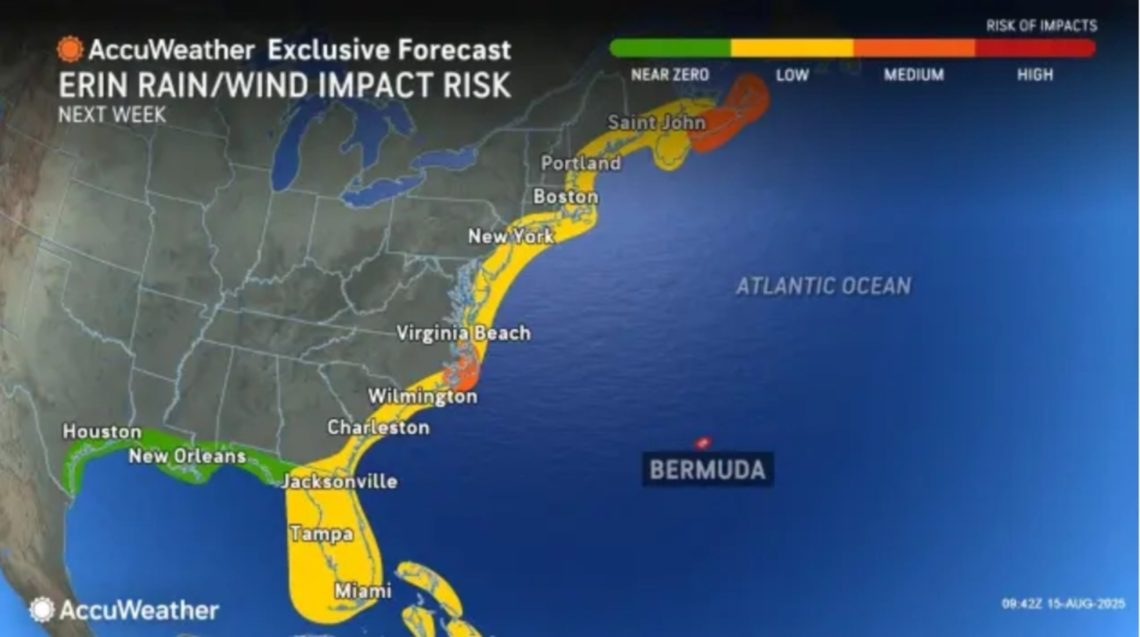
What to Know
As Erin grows in size and strength, AccuWeather meteorologists warned that its impacts could be extensive and far-reaching, hitting areas as far as 100 miles away from the storm’s center.
This means that North Carolina and Virginia coasts have a moderate risk of experiencing rain and wind impacts from Erin as it passes the U.S. Meanwhile, the entire Eastern Seaboard, as well as much of Florida, has a low risk of experiencing impacts.
AccuWeather lead hurricane expert Alex DaSilva told Newsweek that although states should prepare to see impacts from Erin, it doesn’t mean the hurricane will make landfall. Instead, meteorologists anticipate the storm will pass between Bermuda and North Carolina’s Outer Banks.
“At this time, impacts are expected to include dangerous surf, beach erosion and coastal flooding. However, conditions may worsen along the U.S. Atlantic coast, if Erin’s track shifts farther west,” DaSilva said in a report.
Coastal areas such as the Outer Banks; Long Island, New York; and Cape Cod, Massachusetts, are at the highest risk of direct impacts, the AccuWeather report said.
“Erin has not yet started to curve north,” DaSilva said in the report. “The longer Erin tracks west before turning north, the odds increase of impacts potentially reaching the East Coast.”
What People Are Saying
AccuWeather lead hurricane expert Alex DaSilva said in an AccuWeather report: “Erin is moving into a zone of warm water and low wind shear that were already fostering strengthening while east of the Leeward Islands in the Caribbean.”
National Hurricane Center said in a recent public advisory: “Steady to rapid strengthening is expected during the next two to three days, and Erin is forecast to become a major hurricane during the weekend.”
What Happens Next?
Meteorologists will continue to monitor Erin as it increases in size and strength. Those who live on the East Coast should keep an eye out for any updates and follow local weather guidance.
The post Map Shows States to Be Hit Hardest by Erin as Major Hurricane Likely appeared first on Newsweek.