Multiple reported tornadoes caused damage in at least one Colorado county and a Kansas city on Sunday as part of a severe storm system that was expected to bring strong winds and hail the size of golf balls to parts of the Midwest through Monday.
A tornado ripped through the city of Grinnell, Kan., on Sunday night, tearing the roof off a church and destroying several other structures, according to photos shared by NWKS Radio. The city, which has a population of less than 300 people, is about 125 miles north of Dodge City.
A portion of Interstate 70 nearby was shut because of downed power lines, said Lisa Mussman with the Kansas Department of Transportation.
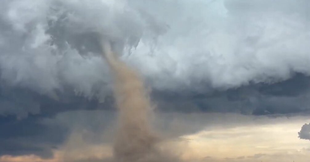
In Colorado on Sunday, there were multiple reported tornadoes in communities outside of Denver, said Greg Heavener, a forecaster for the National Weather Service.
The extent of damage was not immediately known in Adams and Arapahoe Counties where the tornadoes were reported, he said.
Tornadoes were also spotted in Elbert County, which is southeast of Denver.
Those storms caused varying levels of damage to 19 homes, said Kara Gerczynski, the public information officer for Elizabeth Fire Rescue. Many residents were without power on Sunday evening, she added.
Videos posted on social media showed funnel clouds tearing through neighborhoods in Colorado, some of which leveled homes and left behind scattered debris.
Several states were under tornado warnings on Sunday evening, including parts of Kansas, Nebraska, Oklahoma and Texas.
The severe weather is expected to last into Monday, according to the National Weather Service’s Storm Prediction Center. The forecast is potentially for “all severe hazards,” including hail larger than golf balls, strong winds and tornadoes.
The risk is spread across a broad slice of the middle of the country, but is focused on the central Plains into Missouri on Monday.
The outbreak of severe weather comes as the Midwest and the Northeast recover from a spate of deadly storms that generated several strong tornadoes on Friday. In Missouri and Kentucky alone, tornadoes killed at least 25 people, officials said. A rare dust storm swept across central Illinois and into Chicago.
The severe weather is hitting at a time when the Weather Service is facing staffing shortages after the Trump administration ordered cuts. Nearly 600 people have departed through layoffs and retirements.
A forecasting office in Jackson, Ky., which was directly in the line of Friday night’s tornadoes, is one of four no longer with enough staff to operate at all times.
It would have been without an overnight forecaster, said Tom Fahy, the legislative director for the union that represents Weather Service employees. But after an “all hands on deck” scramble, he said, the office stayed open and was fully staffed, issuing 11 tornado warnings.
The three other forecasting offices are in Sacramento; Hanford, Calif.; and Goodland, Kan. Four more, Mr. Fahy said, are days away from losing their overnight staffing: in Cheyenne, Wyo.; Marquette, Mich.; Pendleton, Ore.; and Fairbanks, Alaska.
On Sunday, there was an enhanced risk — level 3 out of 5, in the Weather Service’s categories — for severe weather over the north of Texas, western Oklahoma, Kansas, southwestern Nebraska and the far northeast of Colorado.
“The biggest threat is the hail potential,” said Brian Hurley, a meteorologist with the Weather Prediction Center. “Golf- to baseball-size hail is anticipated.”
Wichita and Topeka in Kansas are two of the more heavily populated areas where thunderstorms could develop.
The area is also at risk for supercells, which are longer-lasting storms that generate large hail and stronger winds than typical thunderstorms. They can also spawn powerful tornadoes.
“The highest tornado threat is going to be from central and southern Kansas into Oklahoma,” Mr. Hurley said.
The severe threat was a classic storm setup across an area notorious for tornadoes, hail and wind.
“The forecast environment for the southern Plains predicts a volatile setup that has not been seen in five to 10 years,” said Sean Waugh, a research scientist with the National Oceanic and Atmospheric Administration’s Severe Storms Laboratory.
The risk of tornadoes in the region will remain in place on Monday. There is expected to be some rain in the mix, too.
Showers and thunderstorms could produce heavy rain over parts of the southern Plains and into the middle and lower Mississippi Valley on Sunday, and they are expected to be more focused over the central Plains into Missouri and Arkansas on Monday.
By Tuesday, the storm system will shift eastward, bringing the threat of severe weather to the Midwest, Tennessee Valley and Ohio Valley.
“The biggest threat is going to be the wind and hail again, but the flash flood threat will also be there,” Mr. Hurley said. “It definitely is a May springtime pattern in the United States.”
Judson Jones and Nazaneen Ghaffar contributed reporting.
Amy Graff is a Times reporter covering weather, wildfires and earthquakes.
Sara Ruberg covers breaking news and is a member of the 2024-25 class of Times Fellows, a program for journalists early in their careers.
The post Tornadoes Reported in Colorado and Kansas as Severe Weather Threat Persists appeared first on New York Times.


