Some of the largest cities in Florida are facing rising sea levels across the state’s coastline, according to new research from the Virginia Institute of Marine Science.
The Sunshine State, which has major settlements along the Gulf and the East Coast, is one of the states most in danger of rising sea levels due to much of its infrastructure being near the coastline.
Why It Matters
The United States’ coastline is densely populated. As sea levels continue to rise, it will be vulnerable to more frequent and intense flooding, coastal erosion, and the loss of critical infrastructure. The new report shows that for six major cities in Florida, rising sea levels over the next two decades could profoundly impact life in some of the country’s largest urban areas and could even lead to displaced communities.
What To Know
The data, mapped by Newsweek, shows that many Florida cities are experiencing faster-than-average sea-level rise, with some areas seeing rates higher than the global average due to regional factors like land subsidence and ocean currents.
Pensacola faced the highest sea level rise, at a rate of 3.709 millimeters a year. Fort Myers and St Petersburg, both along the Gulf Coast, were not much better, seeing rises of 3.706 millimeters.
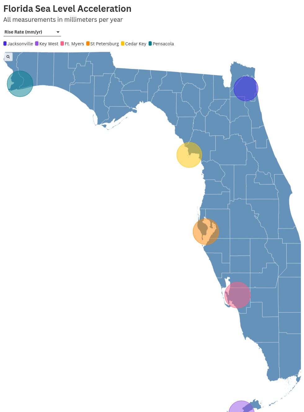
Cedar Key saw the greatest acceleration in rise rate out of the cities the report monitored, with an acceleration rate of 0.195. This is unsurprising, given that Cedar Key is on a cluster of islands loosely connected to mainland Florida, but it signifies how at risk many other urban areas in the U.S. on islands are.
No recorded city reported a falling sea level. The lowest levels of increase from the cities monitored in Florida were in Jacksonville, which reported an increase of 3.287 millimeters a year.
What People Are Saying
Jennifer Carpenter, the deputy executive director of Conservation and Government Relations for The Nature Conservancy in Florida, told Newsweek that the rising sea levels could affect inland infrastructure, due to the nature of Florida’s low and porous coastline.
“Many low-lying, coastal urban areas of Florida are experiencing more regular sunny-day ‘flooding’ (flooding without a storm), due to extraordinarily high tides during certain lunar phases—often called ‘king tides,’” Carpenter said.
“Streets and stormwater infrastructure close to sea level along the coast flood more frequently during king tides. In South Florida, these flooding effects can be experienced miles inland, due to the porous limestone bedrock and a water table that is very near the surface. These occurrences can not only be a nuisance but can also pose a major threat to infrastructure.
“This risk to infrastructure in urban environments from rising sea levels include coastal roads, stormwater infrastructure, buried pipes, and pumping infrastructure that controls our drinking water and wastewater systems.
“These examples of infrastructure threatened by eroding shorelines and saltwater inundation are a major concern for many municipalities along the coast. In addition, rising sea levels make low-lying single and multifamily housing more vulnerable to flooding from both storm surge and rainfall.
“Saltwater intrusion into Florida’s freshwater aquifers—where the vast majority of Florida’s drinking water is sourced—is exacerbated by sea level rise. Another impact of the sea level rise and saltwater intrusion into our aquifer is that it raises the level of the water table, in effect deceasing the amount of rainwater than can be absorbed, which increases the likelihood of flooding from rain events.”
What Happens Next
Much of Florida’s hurricane protection measures also prevent flooding, meaning the state is well prepared for an influx of water. However, the state remains in one of the most perilous parts of the U.S. coastline for rising sea levels.
The post Florida Map Shows Cities Where Sea Level Rise Is Accelerating appeared first on Newsweek.