The air has thawed in the D.C. area this week, and much of the snow and ice from the storm on Jan. 25 is history. But we’re now monitoring the potential for another storm that could bring some wintry weather to the region Sunday into Monday.
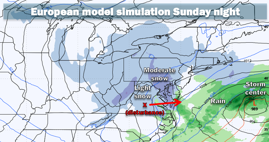
The setup for the storm involves two disturbances — one cutting across the southern United States and one from Canada diving southeastward. If they join over the Mid-Atlantic, they could form a major snowstorm from Virginia up the East Coast. But, more likely, they’ll remain far enough separated that the result is a more minor winter weather event.
For the D.C. area, the more minor weather event would probably entail a mix of rain and snow Sunday and a small amount of accumulating snow Sunday night, especially in colder areas away from downtown D.C.
What are the range of snowfall possibilities?
In the likely event that the two disturbances do not merge, the snow potential for this event is modest. Temperatures would generally remain above freezing during any precipitation Sunday during the day before perhaps settling near 32 at night. These temperatures will limit how much snow can accumulate.
- Chance of at least 1 inch of snow: 40 percent.
- Chance of at least 3 inches of snow: 25 percent.
- Chance of 6 inches or more: 15 percent.
- Chance of 12 inches or more: 5 percent.
In the unlikely event the disturbances merge, the ceiling for snow accumulation would go up quite a bit. On Thursday morning, the American (GFS) model simulated an astonishing three feet of snow in D.C. But it was an extreme outlier among the numerous models meteorologists analyze. We do not believe the pattern would support much more than 6 to 12 inches even if these disturbances do come together because of the lack of cold air in place and the speed at which the storm will probably be moving.
What’s the potential timing of any snow and how could the storm evolve?
The exact timing and details of how the storm will evolve are very much subject to change. But here’s how we see it as of now:
Sunday morning into afternoon: The first phase of the storm (from the southern disturbance) is likely to produce at least a little precipitation in the D.C. area, although there is an outside chance of a total miss. Precipitation on Sunday could be light rain or a mix of rain and snow. Temperatures are probably in the mid-30s or higher, so snow accumulation is unlikely except perhaps a light accumulation on grass.
Sunday evening and overnight: As the disturbance sweeping in from the north cuts across Virginia, it could give our area a period of accumulating snow as temperatures drop into the low 30s. Colder areas north and west of downtown D.C. have the highest chance of at least an inch of snow.
Monday: Any snow should taper during the morning with afternoon highs rising to near 40.
Why is this such a difficult forecast?
The crux of the forecast problem is that it’s unclear where and how fast the storm will form, which relates to the uncertainty as to whether the northern and southern disturbances will merge before they depart over the ocean. This makes predicting how much precipitation will fall extremely difficult.
Moreover, unlike the Jan. 25 storm, there will be little cold air in place ahead of the storm, which complicates figuring out how much precipitation falls as rain versus snow.
For substantial snowfall, the storm would need to explosively intensify close enough to the coast to draw down cold air and spread heavy precipitation across the region. But this scenario is not particularly likely. Most models don’t form the storm close to the coast because they project the southern disturbance to run out ahead of the northern disturbance.
The more reliable models suggest the area’s best chance for snow would come from the northern disturbance as it passes south of the area Sunday night, detached from the southern disturbance (already out to sea).
That said, the models have been struggling on how to handle the timing and interactions between these two disturbances. It may take until Friday or even Saturday for a more definitive forecast.
The post Watching D.C.-area snow threat Sunday as models wrestle with details appeared first on Washington Post.