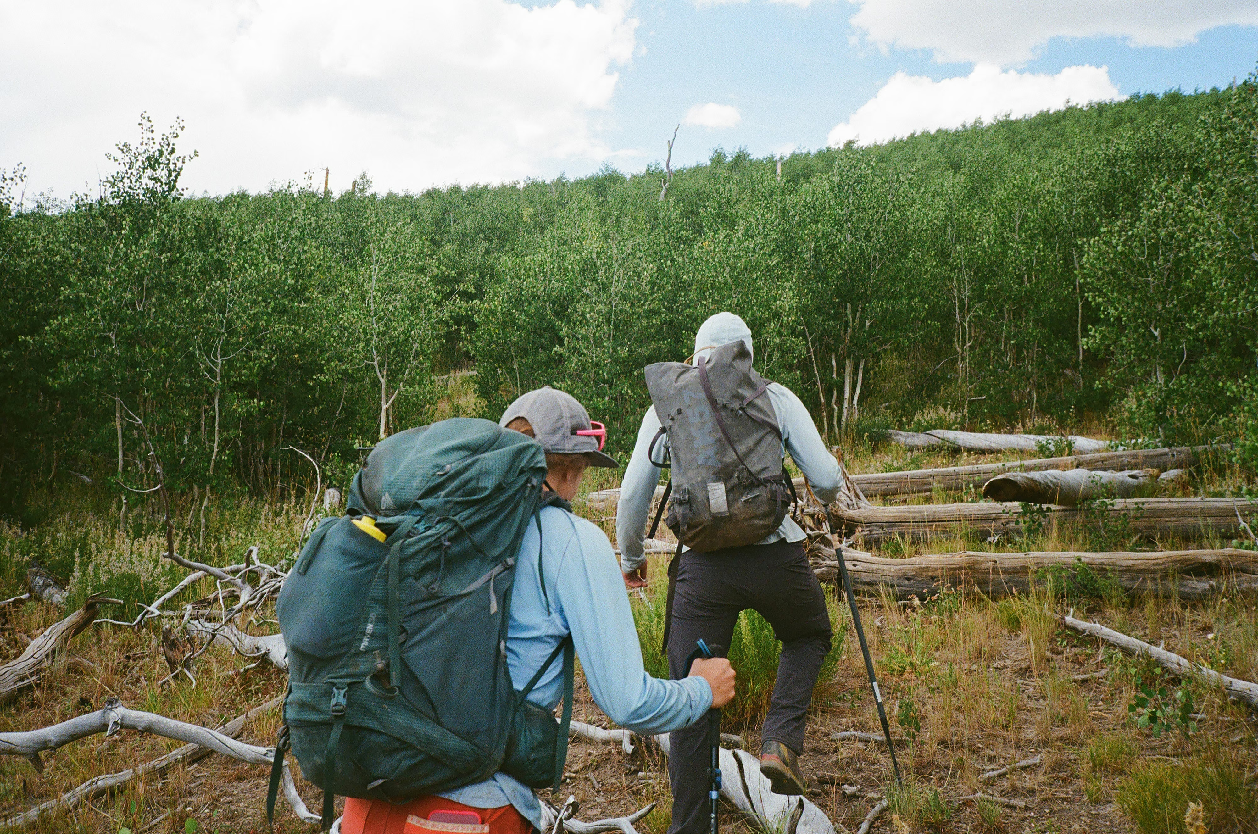
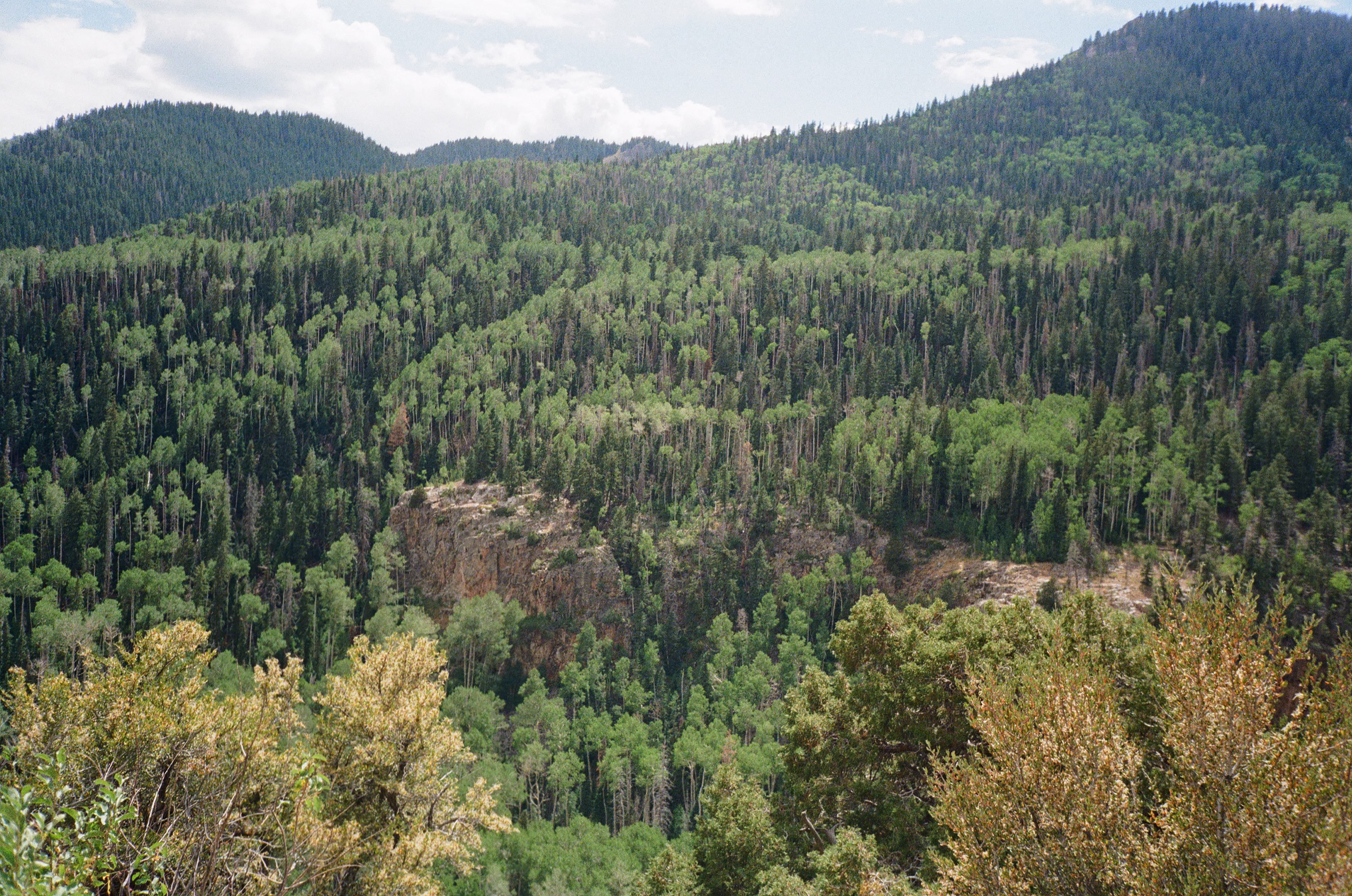
Bushwhacking through a stand of stunted aspens above 10,000 feet in Utah’s Tushar mountain range, the mountain guide Trevor Katz held his Garmin to the sky and pointed it south. “We should just look for an opening,” he said, glancing over at his colleague, Bailey Pugh, from under a ball cap he’d cut into a visor.
He took a few steps steeply uphill, then down, careful not to slide on the scree. “It says it’s right below us, by probably 10 meters. Wait, five.”
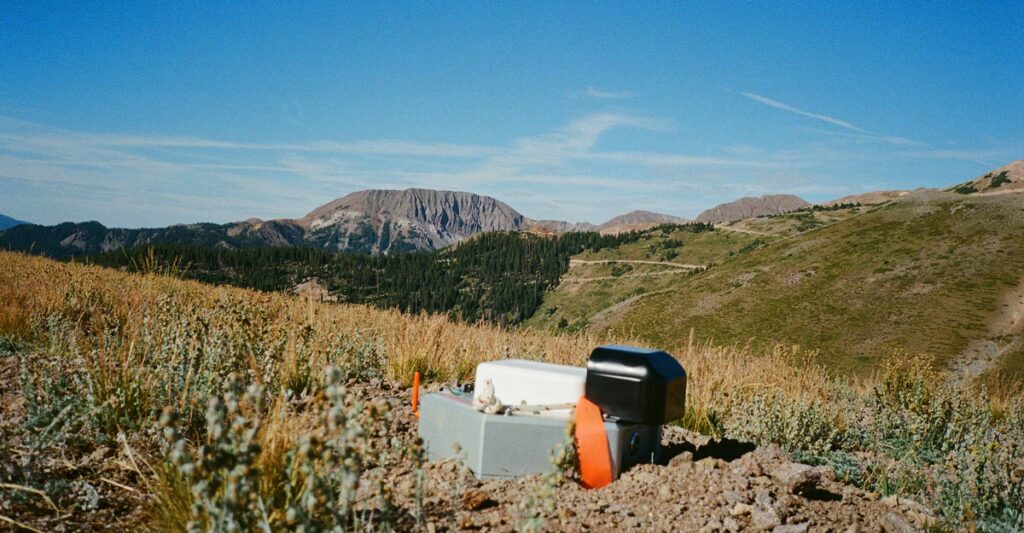
Wading through walls of branches, he and Pugh circled, eyes trained on the ground. Then, there it was. Stuck in the dirt, the hexagonal silver node looked like a device an alien could have planted. Its small antenna and carrying strap sat above the earth. A sharp spike below anchored it into the slope. It would be a strange thing to stumble upon this so high in the mountains, surrounded only by what can survive at such an elevation.
This is just one of 200 nodes planted across the range in a tidy grid, each tracked with a GPS waypoint. Earlier, they had placed the nodes in the ground; now it was time to extract them. Pugh hoisted this one out of the ground and into her pack. Then it was back to bushwhacking.
“This is why they had to hire mountain guides,” Pugh told me, as we picked our steps carefully across boulders.
At the beginning of the summer, Katz and Pugh had received an email from the owner of a guiding company they’d worked for in the past: A client needed mountain-savvy day workers for a new project—any interest? The biggest hint they got about the purpose of the project was the field crew’s meeting place, the Deer Trail Mine, at the mountains’ eastern base. Each team was given a set of GPS waypoints and told to take a 20-pound node, about as big as a football, to each location, plant it in the ground, and mark its location. “It was really mysterious,” Levi Warr, another crew member, told me. But the pay was good—$500 a day, plus a per diem, as much as they’d usually earn for a few days of guiding—and the instructions were clear enough, so out they went.
Only as the summer went on did the crew come to understand, from chatting with the project geologists and fieldwork managers, what exactly they were doing: helping locate some of the nation’s most in-demand minable resources across a patchwork of public and private lands. Arranged in grids that connect to low-Earth-orbit satellites, the nodes are capable of collecting and sharing data used to create high-resolution maps of anomalies, miles underground, that might be gold, copper, nickel, lithium, or other minerals.
The nodes used in the project were first released three years ago by the Australian company Fleet Space Technologies, and although they’ve been adopted by mining giants internationally, how widely they’re being used in the United States is unclear. Compared with older and more invasive survey methods, this technology can be deployed with minimal impact. According to Fleet Space, it can be particularly useful for surveying areas where permits are required—for the Fishlake National Forest, for example, and the Bureau of Land Management territory enveloping the Tushar Mountains. If this quiet method of mineral exploration is successful, it will have threaded a loophole in the law governing public lands, helping open them for mining that much more quickly—and controversially. All it will take is a few hundred nodes, a clear view of the sky to connect to satellites, and a small team of people who know how to traverse rough terrain.
Historically, mining-exploration projects have depended on a giant boom. Drop hammers, trucks with vibrating baseplates, and dynamite blasts send seismic waves through the Earth’s subsurface to a grid of geophones. The waves’ travel times are translated into rough maps of mineralized zones. On U.S. public lands, taking even this first step toward a new mine means getting approval, whether from the Forest Service or the BLM, a process that can be stringent and slow, requiring data collection and environmental assessment.
Instead of shakes and booms, Fleet Space’s node system relies on the naturally occurring vibrations of the earth and the sound waves created by those walking upon it. These scraps of seismic data from everyday life are gathered by the nodes’ internal geophones. After collection, the data are processed into “ambient-noise tomography,” or ANT, surveys, which provide the highest level of detail of what is underground, compared with traditional methods. (Fleet Space did not respond to a request for comment.)
The American West has long led the country in producing gold, copper, coal, and silver, as well as rare, sought-after elements, such as beryllium, that can be used for aerospace and defense technologies. The unique geologic profiles here—the Colorado Plateau, the Basin and Range region, the Rocky Mountains—are side effects of ancient inland seas, volcanic history, and an active boundary between two tectonic plates. Billions of years of pressure, folding, and depositing created a region rich with minerals just close enough to the surface to mine.
In the 1860s, white settlers flocked to what would become Marysvale, where the Deer Trail Mine is now located, with high hopes to strike gold, silver, and copper. By the 1930s, though, most of the mines had closed: The shallower, more accessible resources had been tapped, and it was too expensive to keep trying to get rich.
Over the years, a series of companies have bought the Deer Trail Mine in failed attempts to revive it, Helen and Alan Johnson told me. They’re lifelong residents of Marysvale and former employees of the mine, and they agreed to meet me at a Mexican restaurant in Orem, Utah, to talk history. Most recently, in 2018, MAG Silver, a Canadian company, bought the mine. The new owners had started exploring national-forest land for silver, gold, and copper with more traditional methods before turning to the Fleet Space nodes for this summer’s surveys.
These minerals, plus others that Fleet Space nodes can help discover, including cobalt, nickel, and lithium, are all on the country’s list of critical minerals. Demand for these materials is growing exponentially: Together and separately, they are used in iPhones, photovoltaic panels, combat drones, and many other technologies now key to Americans’ quality of life or national security. Some materials, like diamonds, can be whipped up in labs, but these particular resources come only from the ground.
Now the right combination of technology and political timing could mean that whatever is still in Utah’s mountains and elsewhere could be within reach for those who want it. As tariffs have kicked in and America seeks to ease its reliance on China for refined metals and minerals, the Trump administration has turned its attention to opening up U.S. land for mining—even when that means that the companies doing the mining aren’t American ones.
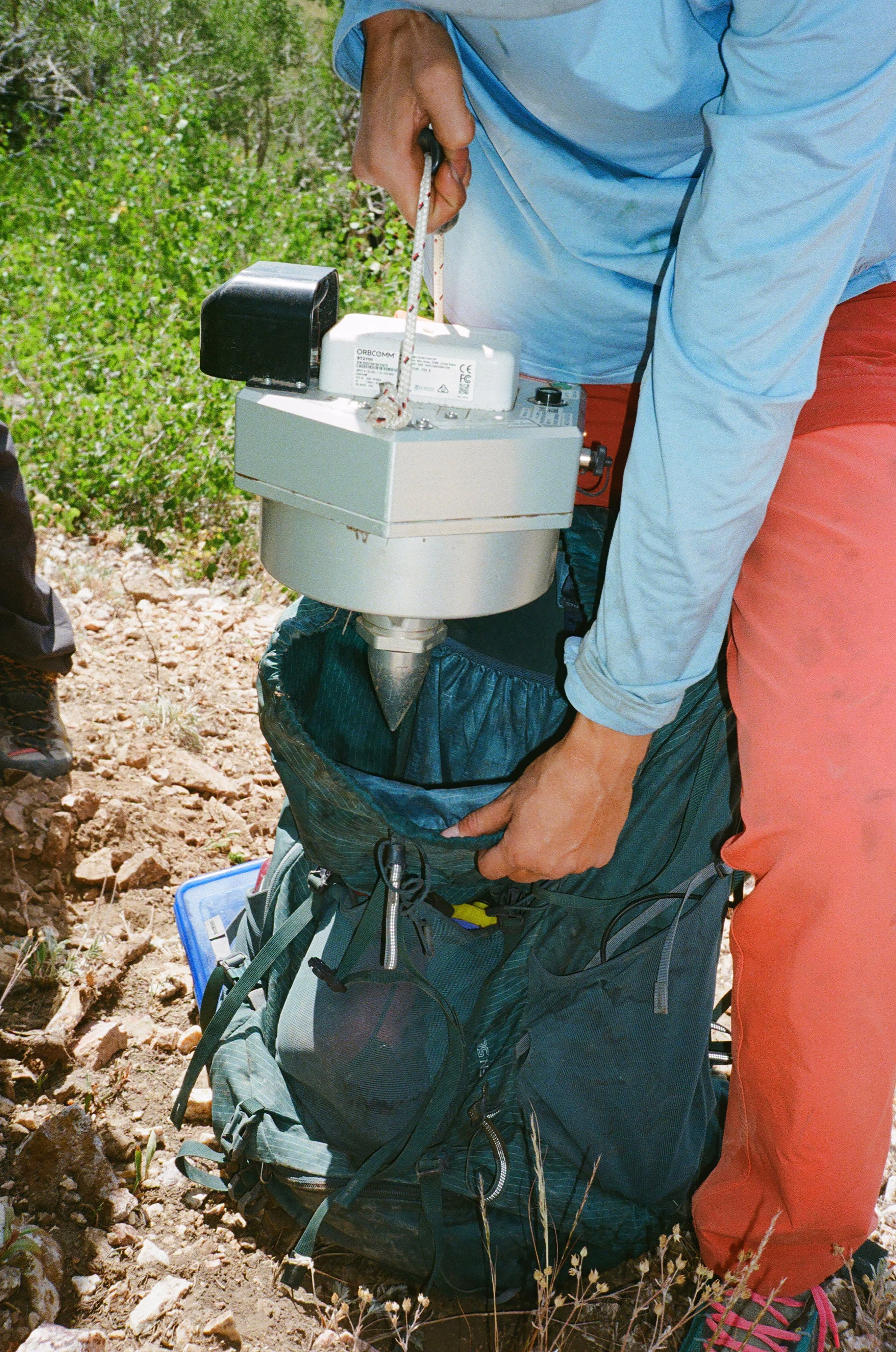
To plant one of the ANT nodes, Trevor Katz told me while walking up a slope scattered with juniper trees, does not require much. Hike in with a pickax, dig a hole a few inches deep, and place the sharp end of the node into that hole, making sure the spike containing the geophone is completely covered. To extract it, just pull it out of the ground and hike it out.
He and Pugh did this over and over, often putting in a dozen miles a day, as the field crew placed and extracted 200 nodes four separate times, first for a regional survey that covered about 50 square miles across BLM territory, national forest, and land the mine already owns, then for three surveys, mostly on Forest Service land, that made a more detailed search for anomalies.
To regulate mining activities on public land, balancing its responsibility to both conserve the land and make it useful, the Forest Service is supposed to consider an activity’s “surface disturbance.” Exploration that’s unlikely to cause “significant” disturbance can go forward without the Forest Service’s involvement. This distinction has helped separate casual use of public lands—such as private citizens panning for gold, which anyone can do freely—from commercial activities.
The surveys conducted last summer for the Deer Trail Mine project didn’t have any permits associated with them. I filed a Freedom of Information Act request for documentation of the ANT surveys filed by or on behalf of any of the stakeholders involved in the project, including MAG Silver and the Deer Trail Mine; none were filed with the BLM or the U.S. Forest Service. The companies involved in the project either did not respond to requests for comment or declined to comment for this article. The Fishlake National Forest Ranger Station, which has long worked with Deer Trail Mine and is responsible for all permitting and communication regarding the company’s mining activities on Forest Service land, told me that any commercial exploration at all would be expected to be disclosed to the rangers but that the station had no knowledge of the ANT surveys.
A spokesperson for the Forest Service’s national press office told me, however, that this type of survey does not need a permit or even a formal notice of intent, which the agency uses to determine whether further oversight is needed. But the legal experts I asked about the ANT nodes told me that they fall into a gray area of the law.
The key term is “significant disturbance,” Elizabeth Craddock, a government-relations attorney and a partner at Holland & Knight in Washington, D.C., who specializes in natural resources, told me. But the regulation itself doesn’t define what significant means, she said, so what counts is up for interpretation. These commercial-exploration projects seem to have found a way to quietly bypass federal regulations that outline how and when approval is given before exploration begins on public lands.
If the Deer Trail Mine project goes back into operation, it will need permits. This past fall, it was acquired, as part of MAG Silver, by another Canadian company, Pan American Silver—which has not pursued any further work on the project so far. But any next steps toward reopening a mine here could go faster than ever too.
Last March, President Trump signed an executive order directing federal agencies to expedite mining projects and prioritize mining activities on public lands. The administration has also made changes, at least temporarily, to the National Environmental Policy Act review process to accelerate project approvals. Agencies are no longer required to analyze long-term environmental effects that are hard to trace back to the initial cause, which significantly reduces the scope of every project’s review.
Opening up new mining operations would be in keeping with the founding directive of the Forest Service, which mandates the balance of protecting resources and extracting them. Many mines give small, rural towns a needed economic boost too—in Marysvale, for instance, the median household income is $28,750 a year, and the unemployment rate is 63 percent.
Still, while he’s out retrieving the nodes that could make new mines a reality, Katz told me, he’s been “telling myself the little copes that everybody does”—that it’ll be a long time before this land is developed. Looking out over the windswept tops of Mount Holly and Delano Peak, into a valley meadow called Horse Heaven, and across the entire range, I imagined 800 empty holes where the nodes used to be. Katz had mentioned that the project’s marketing materials clearly said that all the holes would be filled in—perhaps a gesture toward a remediation plan for the survey’s relatively small impacts—but that he and other guides had not, in fact, filled them in. Those holes were nothing you’d see unless you were looking; it’s likely that the first hard autumn rain quietly washed them away. But if this particular combination of technology and policy does add up to more mining across the country, the result will be loud and obvious.
The post The Mysterious Devices Speeding Mining Exploration in Utah appeared first on The Atlantic.