In 2020, Eric Gilbertson, a mechanical engineering professor at Seattle University, climbed the 100 highest mountains in Colorado. Or so he thought.
In 2021, he found something concerning in data published by the United States Geological Survey about a summit called Crestone Peak. It’s one of Colorado’s famous 14ers, mountains that reach beyond 14,000 feet.
The data made the mountain appear pointier — and so perhaps taller — than Dr. Gilbertson knew it to be from standing on its summit. And just 400 feet eastward was another spot, which he now calls East Crestone. Its height in the data seemed to match Crestone Peak. Was East Crestone, he wondered, the actual summit?
“The only way to know for sure is to go and take down measurements,” he said.
Dr. Gilbertson is known for this D.I.Y. attitude when it comes to mountains. He has found numerous errors in published records for the world’s mountainous peaks, a result of climbing collaborations with his fraternal twin brother, Matthew Gilbertson, a mechanical engineer working in the space systems division at Lockheed Martin.
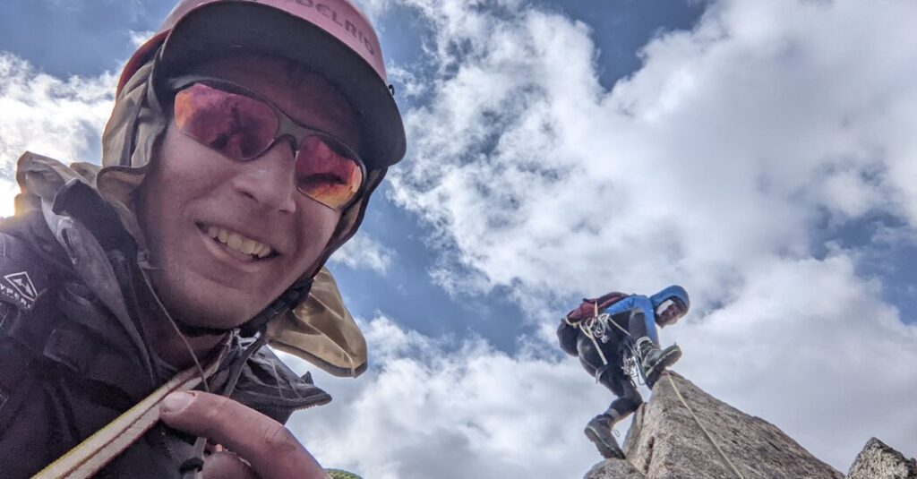
When the brothers climb mountains, they take not just food, water and first aid, but also advanced surveying equipment. At the top of wherever they and an assortment of climbing partners find themselves — whether Crestone in Colorado or Dinara in Croatia — they set that equipment and gather data about a mountain’s precise elevation. The brothers are correcting the world’s topographic record, one peak at a time.
And so, this year, Eric went back to Southern Colorado, on this climb without his brother. He scaled East Crestone, a formidable shard of rock requiring a risky scramble, and began the hourslong process of collecting elevation data. Right away, he hopped over to Crestone Peak, the slightly more rounded point that people have been climbing, claiming altitudinous victory, for a little over a hundred years. There, he gathered a set of simultaneous measurements.
East Crestone, he soon found, was one-third of a foot taller than Crestone Peak, and the true top of the mountain, a finding published last month in the journal Progress in Physical Geography: Earth and Environment.
The brothers also published a separate paper in late November that established new high points in five countries. It’s part of a project the twins run, appropriately called Country Highpoints, in which they climb the highest mountains in every nation; partway through their endeavor, they began measuring them. So far, between them, they’ve climbed 149 peaks and gathered data on many of them. (The Gilbertsons have also tried to climb Everest, and have summited Aconcagua, Mont Blanc and Mount Elbrus, among many other big-name peaks.)
“Our goal in all this is to find the truth,” Matthew said.
50 States, 50 Peaks
As kids in Kentucky, the Gilbertson twins trekked through the Appalachian foothills and the Smoky Mountains. In college, they both enrolled as mechanical engineering students at the Massachusetts Institute of Technology, staying through their doctorates. There, they joined the M.I.T. Outing Club, an outdoor recreation group. With that crew, they learned mountaineering skills on trips to New Hampshire, where they decided to climb all the state’s mountains that are 4,000 feet and taller.
They blazed through that to-do list. Then, lists begetting lists, they climbed the highest points in all 50 states.
Denali, the highest point in Alaska, and also the highest point in the United States, set them off on a new to-do tangent. “We already had one country,” Eric said. “That would be a great excuse to visit every country in the world.”
This global list, though, required more than they got from their college club. “You don’t just need high-altitude mountaineering experience,” Eric said. “You also need to do jungle bushwhacking. You need to speak a lot of different languages. Need to do desert travel. But also you need to figure out what is the highest mountain in the country.”
And that, perhaps, was the most difficult part. They discovered this when they went to climb Saudi Arabia’s top spot.
A mountain called Jabal Sawda was listed as the superior point, based on satellite measurements. But that estimate had a margin of error, and another peak, Jabal Ferwa, was within that margin. Historical surveys done by the American and Soviet militaries gave conflicting information.
The Gilbertsons had no option but to climb both mountains, gather data and settle a debate that no one else seemed to know existed. And so they rented specialized surveying equipment.
The GPS devices they schlepped to the tops of the Saudi mountains — and continue to carry around the world — are called Differential Global Navigation Satellite System units. They are more accurate versions of the GPS installed in phones. They can collect data for hours; access a greater number of satellites; compare data with nearby base stations; and correct for atmospheric distortions and the bouncing of signals off trees, buildings and other obstacles. The results are uncertainties of about an inch, while the “you are here” dot on a phone has errors typically measured in feet.
What the brothers found in Saudi Arabia conflicted with the record. Jabal Ferwa was around 10 feet higher than Jabal Sawda.
“That got us thinking, If this is the case in one country, it could be the case in other countries, too,” Eric said.
New Peak Who Dis?
They started the data-driven Country Highpoints: an effort to climb all the peakiest peaks and find, once and for all, which ones are highest and how far into the sky they extend. It’s not just another climbing list; it’s a rewriting of cartography (if, of course, the geologic arbiters in a given country accept the results).
No matter where they’re going, the Gilbertsons begin by looking at satellite data that provides a digital elevation model like the kind on Google Earth. From these, they determine how many candidates in each nation rise within the margins of error of the highest published mountain. Then they climb each candidate with their GPS devices, set their tripods on spiky topography and spend hours waiting for the data to ping in.
Saudi Arabia had only the two candidates. Gambia, on the other hand, had four. In Uzbekistan, the effort pointed to a mountain that did not have any recorded ascents and appeared to lack accurate survey measurements. Getting to its top required a 20-mile trek to the mountain before the technical climbing began. And the climbers — this time, Eric and two partners — had to do this twice with two different instrument tripods before they were able to clock Uzbekistan’s new high point, at 15,314 feet and 11.52 inches.
Sitting on such summits for hours, the brothers treat each peak like a place to be instead of a place to tag and then abandon. In seven countries, they have changed the land’s geography, establishing previously unrecognized high points, and so knocking seven summits off the list. In addition to establishing that Sare Firasu Hill in Gambia, Jabal Ferwa in Saudi Arabia and Alpomish in Uzbekistan are high points, they have found new superior elevations in Togo (Mount Atilakoutse) and Guinea-Bissau (Mount Ronde). These were recently published in the same journal as the Crestone finding.
A paper about Botswana’s apparent new big bump, Monalanong Hill, is in preparation, in collaboration with professors at the University of Botswana.
Data on another new apex, in Colombia, is undergoing peer review; it hinges on the fact that the previous high point, last surveyed in the 1930s, was capped in ice that has since melted.
“You think that a mountain height is fixed and it never changes, and you can kind of rely on that,” Matthew said.
The brothers’ work has instead shown the planet to be always changing.
For instance, the high point of Mount Rainier in Washington is officially Columbia Crest, an ice dome covering part of the active volcano.
“It’s actually no longer the highest point,” Eric said. A climb in 2024 showed that a rocky spot on the southwest rim, not so subject to a warming Earth, is now more than 10 feet higher, according to data recently published in the scientific journal Arctic, Antarctic and Alpine Research and recognized by the American Alpine Journal, the climbing community’s paper of record.
“I’m not really sure how you can make it more official than that,” Eric said.
That’s because, while the U.S. Geological Survey makes topographic maps and collects and maintains a comprehensive elevation data set, it doesn’t keep a comprehensive list of remeasured summits. “We do not conduct mapping surveys to determine officially recognized mountain-peaks heights,” said Jason Burton, a spokesman for U.S.G.S. Core Science Systems. He directed more detailed questions to the National Geodetic Survey at the National Oceanic and Atmospheric Administration.
The National Geodetic Survey is tasked with defining the map grid on which terrestrial things are measured; it keeps a precise database of survey points across the United States, including peak heights where they are relevant to its surveys of latitude and longitude. But it is not the agency’s role to measure specific mountain peaks. Previously, external surveyors could submit data to the N.G.S.’s Integrated Database if they met specific standards laid out in a publication colloquially called the blue book; the Gilbertsons say their measurements meet those standards.
Eric has been working with a professional surveyor to submit their measurements of Mount Rainier to the geodetic survey, with plans to submit East Crestone data later, followed by other measurements if those two go well.
The National Geodetic Survey’s process for incorporating submitted data is in flux and largely on hold at the moment, with the agency rewriting its software and changing its reference frames.
Still, that database doesn’t represent a comprehensive set of measurements; such an official catalog of mountain peak heights does not seem to exist.
In Colorado, and perhaps in the seven countries with newly stretched and shrunken mountains, people may use the Gilbertson Standard, if they so wish.
But if “East Crestone” is to be recognized as a name of a new peak in Colorado, it’s up to the state’s Geographic Naming Advisory Board. According to Chris Arend, a spokesman for the Colorado Department of Natural Resources, that process can take years.
You can only rewrite maps, it turns out, if the mapmakers say so. But the brothers will keep climbing, recording and publishing anyway. They want to put forward new truth, back it with rock-solid rigor and let the world do with that information what it will.
That’s an additional layer of motivation on top of the attitudes of many mountaineers. After all, when a New York Times reporter asked George Mallory in 1923 why he was going to climb Everest, he famously replied, “Because it’s there.” The Gilbertsons, on the other hand, climb to uncover the there there.
The post Twins’ Peaks: The Gilbertson Brothers Want to Rewrite Your Country’s Map appeared first on New York Times.