Just after a strong winter storm blanketed areas of the Northeast in snow and disrupted post-Christmas travel on one of the busiest weekends of the year, another fast-moving system will bring a mixture of rain and snow blended with a blast of Arctic air that will usher in below-average temperatures along much of the East Coast to start off the New Year.
Both New York and New Jersey were declared to be in a State of Emergency by government officials and thousands of flights were delayed and canceled in the region Friday.
Now, a long, trailing cold front will become the focus for millions, threatening a dangerous mix of severe storms, flash flooding and potentially feet of lake-effect snow in its wake.
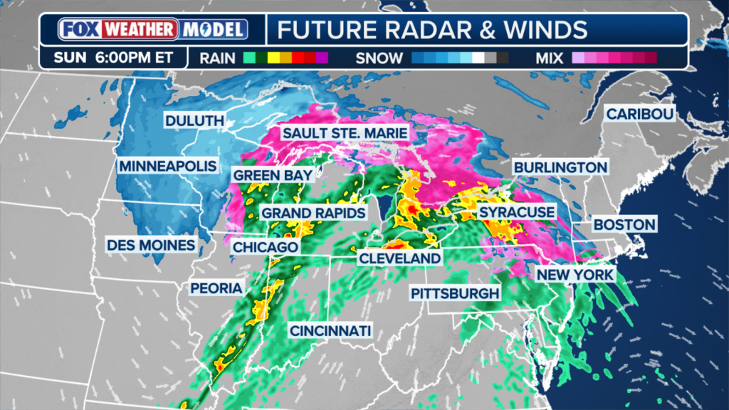
Starting on Sunday, the low-pressure area will swing through the Upper Midwest, bringing with it rain, snow and gusty winds.
By Sunday, the system will usher in cold air as it moves east, allowing snow to develop in areas from Minneapolis into Michigan.
While general snow totals will range from 5 to 8 inches, the arrival of colder air and shifting winds across the northern Great Lakes could trigger lake-effect snow totals of up to 18 inches in localized areas, according to the FOX Forecast Center.


Further south, along Lakes Michigan and Erie, the combination of moisture and rapid snowmelt closer to the low-pressure center creates a brewing flash flooding risk.
While rainfall totals will generally average 1 to 2 inches, the existing snowpack and warm temperatures ahead of the front increase the flood potential for cities from Chicago to Cleveland and Buffalo.
Ahead of the front, rain will sweep across the eastern Great Lakes. As the front extends south into the Tennessee Valley, some stronger storms, potentially severe, may develop.
A Level 1 of 5 severe storm threat exists from northern Indiana south into Missouri, including Indianapolis, St. Louis, Louisville and Nashville.
The primary threat will be damaging wind gusts, though given the present wind shear, a few isolated tornadoes cannot be ruled out.
INTO THE NORTHEAST
As the front pushes east Sunday evening, rain will spread across the Northeast, clearing out snow that remains in affected areas. Most areas will remain above freezing, limiting snow chances for the majority of the region.
Icing appears likely where cold air remains trapped, which will create travel hazards across New England, particularly in high-elevation areas.
Winter Weather Alerts have been issued for most of New England for the potential of ice up to 0.10″.
Locations along the I-95 corridor will remain warm enough for the system to fall entirely as rain.


A quick burst of high, gusty winds is likely from the Midwest to the Northeast. Power outages are also possible.
A rush of much colder air will arrive as winds pivot out of the northwest, triggering significant lake-effect snow downwind of Lakes Erie and Ontario.
Portions of Western and Upstate New York are expected to see plowable snow through Tuesday, with totals potentially exceeding one foot.
The post Next major storm system threatens Midwest with high winds, snow and rain before sweeping into Northeast appeared first on New York Post.