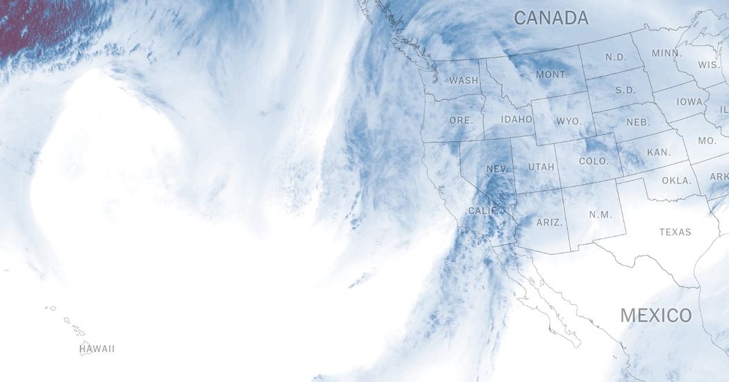
A strong, wet storm was set to deliver gusty winds, heavy snow and drenching rains across California beginning Wednesday evening, and forecasters are growing increasingly concerned about its potential to bring flash flooding to Southern California in the coming days.
This complex system will bring potentially the most widespread and heaviest precipitation to the state so far this fall, and the heavy soaking is expected to bring a decisive end to the state’s wildfire season.
Here are the key things to know:
- One or more inches of rain is forecast across the state, with two to four inches of precipitation in the foothills and mountains and potentially up to seven inches in the wettest locations.
- While this storm is expected to move quickly across Northern California, models suggested the storm would stall over Southern California, potentially bringing more rain than earlier forecasts suggested.
- With those models, expectations for the storm intensified quickly on Wednesday among forecasters in Southern California. “There’s a lot of uncertainty in when the rain is going to start and how long it’s going to last and how much we’re going to receive,” said Todd Hall, a meteorologist with the National Weather Service office for the Los Angeles area.
The rain will hit Northern California first.
In the Bay Area, the bulk of the rain is expected to fall overnight Wednesday into Thursday morning, bringing the potential for minor flooding on small streams and urban areas with poor drainage.
“It’s forecast to move through the Bay Area at a decent pace,” said Roger Gass, a meteorologist with the Weather Service’s office in Monterey, Calif. “Anywhere from midnight tonight through tomorrow morning will be the greatest impacts.”
Scattered showers are expected through Friday. Most urban locations, including downtown San Francisco, are predicted to receive a half inch to one and a half inches of rain through Friday morning, with the mountains of the North Bay and the Santa Cruz Mountains likely to pick up four to five inches, according to Mr. Gass.
While there is a small risk of flooding across most of the Bay Area on Thursday, the Weather Service is unlikely to issue a flood watch, since widespread flooding is not expected on large rivers, Mr. Gass said.
The Weather Service issued a wind advisory for the greater Bay Area, warning of damaging winds Wednesday night into Thursday morning. A more severe wind warning was issued for some areas, including the North Bay and the hills of Marin County, with winds of up to 60 miles per hour possible.
The rain will push southward into Central California late Wednesday night into early Thursday. This region — the Big Sur coast, where Highway 1 winds along rocky cliffs that plunge into the sea — could see some of the heaviest rains, with three to five inches very likely and up to seven inches possible.
Southern California’s forecast is evolving quickly.
There is still significant uncertainty in the forecast for Southern California, where meteorologists have become increasingly concerned about the storm stalling and dropping a fire hose of rain over the region for several days.
The Weather Service said the rain was likely to arrive in Santa Barbara County mid- to late morning on Thursday before pushing into Ventura and Los Angeles Counties on Thursday afternoon.
Because the storm may stall off the coast, the chance for rain continues into Friday and Saturday, potentially even Sunday.
Downtown Los Angeles could record anywhere from one inch to six inches, Mr. Hall said, but two to three inches was the most likely outcome as of early Wednesday afternoon.
“We’re going to get rain, we just don’t know the amounts,” he said.
The mountains above Santa Barbara and Ventura Counties and the hills of Los Angeles could record up to seven inches of rain through Saturday, raising a growing concern of landslides.
Wildfires, including the catastrophic fires in Los Angeles in January, have torn through these areas in recent years, and the landscape is particularly susceptible to landslides and debris flows. The Weather Service and state and local officials said they were closely watching this area to determine whether to issue warnings and evacuations.
“We’re going to get flooding, but we just don’t know whether it’s going to be road flooding or debris flows in wildfire areas,” Mr. Hall said.
In the southernmost area of the state, San Diego is expected to see lighter rains for Thursday night into Friday morning, with increasing chances for heavier rainfall on Friday into Saturday. In San Diego County, low-lying areas could record two to two and a half inches of rain with up to four inches in the mountains.
Amy Graff is a Times reporter covering weather, wildfires and earthquakes.
The post ‘A Lot of Uncertainty’ Suddenly Surrounds a Storm Hitting California appeared first on New York Times.


