The same regions that have been choked with wildfire smoke since the middle of last week are now bracing for severe thunderstorms. From the Upper Midwest to the Northeast, a turbulent weather system on Monday and Tuesday could bring damaging winds, large hail and even tornadoes.
Forecasters are concerned not just with the storms themselves, but with how this shifting weather pattern could create near-critical fire conditions when it sweeps back across the Upper Midwest.
Here is what to expect and when.
In the Midwest on Monday: Storms, Tornadoes, and Shifts in the Smoke
Wisconsin is no stranger to tornadoes. The state has already recorded 39 tornadoes this year, tying it for the sixth-most on record. The state’s highest annual total, 62, was set in 2005.
“There is a pretty decent threat for tornadoes in this part of the country Monday,” said Ben Miller, a meteorologist with the National Weather Service in Milwaukee.
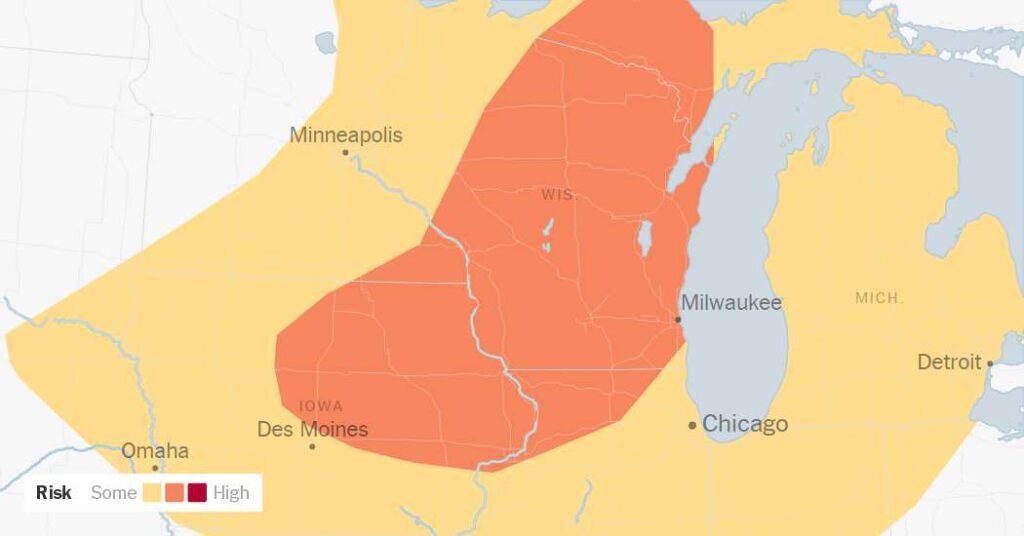
Meteorologists with the Storm Prediction Center, an arm of the Weather Service, have highlighted an area with a risk of strong tornadoes from Iowa up through Wisconsin Monday afternoon and evening, alongside a high probability of hail and damaging winds.
Still, the region is desperate for moisture.
“To be honest with you, we need the rain,” Mr. Miller said. “It’s been places where it hasn’t rained since basically the Fourth of July weekend. We’ll take every little bit of rain we can get. We’d just as soon not have to deal with the severe weather to get it, but this time of year, generally, one comes with the other.”
On Monday, Milwaukee was still dealing with lingering haze from the wildfires. Forecasters said they hoped the smoke would remain light, but warned that after the storms pass overnight, winds shifting from the northwest could pull a fresh plume of smoke across the region and into the Northeast.
Smoke forecasting is notoriously difficult because it is hard to predict exactly how much smoke a fire is actively producing.
Based on computer forecast models from fire agencies, meteorologists do not expect intense new fire growth because humidity levels will prevent the air from becoming entirely dry. But the situation remains precarious for forecasters like Joe Moore, a meteorologist in the Weather Service’s Duluth, Minn., office, who is monitoring both Monday’s severe storms and active wildfires.
Many of the current fires were ignited by lightning strikes, a threat that Monday’s storms could renew.
Mr. Moore noted that recent light rain had dampened the area and that humidity levels would rise overnight. His primary concern, he said, is the wind, which could suddenly fan new fires.
Farther south, areas around Chicago face a lower risk of severe weather on Monday. Morning storms moving through Illinois may decrease the chances of severe weather later in the afternoon, though forecasters are watching the area closely.
Some good news? Mr. Miller said the front will offer some relief from the heat. “It will be nice to get some cooler temperatures as this Canadian air moves through,” he said.
In the Northeast on Tuesday: Intense Winds and a Collision of Systems
That same cooler air mass pushing south and east will drive the severe weather on Tuesday, as it moves out of the Midwest and through the Northeast by the end of the day.
As it advances, this cooler air mass will collide with a dense layer of moisture being drawn to the north by a system in the Gulf of Mexico that could become Tropical Storm Bertha as soon as Monday.
Forecasters with the National Weather Service said there was still significant uncertainty regarding just how severe the weather on Tuesday will be. As of Monday morning, there appeared to be a potential for storms to produce large hail and damaging winds near the intensity of a hurricane — 74 miles per hour or higher.
The highest probability for the worst of the storms stretches from northeastern Kentucky to western Pennsylvania, including Pittsburgh.
However, major metropolitan areas along Interstate 95, including Washington, Baltimore, Philadelphia and New York, could also experience strong thunderstorms. Forecasters said they could not rule out the possibility of tornadoes. Many of those same areas experienced flooding and strong winds over the weekend.
The post Wildfire Smoke Gives Way to Powerful Storms Threatening Millions of People appeared first on New York Times.