The D.C. area may experience its first snow of the season Friday — at least technically. A storm system sliding across the Southeast may throw enough moisture north into cold air entrenched over the D.C. area to produce a period of light snow.
This is not a big storm, but the potential snow may coincide with Friday morning’s commute, causing some disruptions for travelers. Air and ground temperatures will probably be low enough for the snow to stick, causing slippery spots on untreated roads and sidewalks.
The National Weather Service has issued a special commuting statement, cautioning of the potential for hazardous conditions. “If this threat does materialize during the Friday morning rush hour, many roads could quickly turn icy,” the Weather Service wrote. “This could lead to dangerous traveling conditions, multiple accidents, and extensive delays.”
The Weather Service has also posted a winter weather advisory for most of the D.C. region. The advisory, which runs from 4 a.m. to 4 p.m. Friday, covers Loudoun, Montgomery and Howard counties and points south.
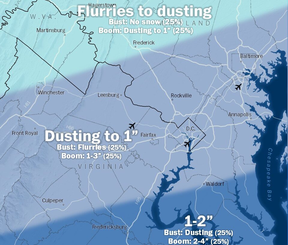
Confidence in snowfall is highest south of the Beltway, while the northern parts of the region, nearer the Pennsylvania border, may see only flurries.
For most of the D.C. area, a dusting to an inch is most probable, although amounts could climb to 1 to 2 inches in north-central Virginia (including Fredericksburg) and Southern Maryland (including Waldorf). The Weather Service has issued winter weather advisories from around Fredericksburg southward.
Because the region is along the northern edge of the storm, small shifts could alter the forecast substantially. If the storm jogs a bit to the north, the Beltway area could receive at least an inch or two; if it slips south, there may be no accumulation.
This potential snow, the first of the season for the Beltway area, is occurring Dec. 5 — which snow lovers once referred to as a day of destiny. Between 2002 and 2009, snow fell five times on this date.
Snow timeline in the immediate region
3 to 7 a.m.: Light snow develops from southwest to northeast but may not reach northern Maryland. Temperatures 25 to 30.
7 to 11 a.m.: Light snow, steadiest south of the Beltway. Flurries or just cloudy skies in northern Maryland. Temperatures rising to 28 to 32.
11 a.m. to 3 p.m.: Light snow and flurries taper off from west to southeast. Northern areas may just have cloudy skies. Temperatures rising to 30 to 34.
Late afternoon and evening: A few flurries or even a little freezing drizzle could linger in Southern Maryland in the late afternoon; otherwise, remaining mostly cloudy. Afternoon highs from 30 to 35 dip into the upper 20s and low 30s after sunset.
Snow impacts
Ordinarily, this potential snowfall would be little more than a nuisance. But the fact it may occur during the morning commute could cause some disruptions. Freezing temperatures (in the 20s) ahead of the snow will allow it to accumulate immediately, making untreated roads and walkways slippery. As such, there is the potential for some school delays and cancellations Friday, especially in jurisdictions south of D.C.
The intensity of the snow should generally be light, meaning clearing crews should be able to keep up with it and it mostly shouldn’t fall fast enough to overwhelm pretreated surfaces.
The event’s relatively short duration — not lasting more than about six hours in any one location — will also limit its impact.
On Capital Weather Gang’s winter storm impact scale, this rates as a Category 1 out of 5.
What about areas south of Northern Virginia?
A broad 1 to 3-plus inches are possible in much of Virginia and northern North Carolina.
Winter weather advisories are in effect in the mountains of North Carolina, as well as much of Virginia, as far north as the D.C. area. Fredericksburg. Richmond, Charlottesville and Roanoke are included. The advisories run from overnight Thursday through as late as Friday afternoon.
Within the winter weather alert area, a general 1 to 3 inches of snow is likely, along with isolated greater amounts, except only dusting to a 1 inch in the D.C. area. The highest totals will tend to favor mountainous areas or zones where snow banding is persistent.
When and where snow will fall in the broader region
Snow will begin in eastern West Virginia, Virginia and western North Carolina around midnight late Thursday. It will expand east into the predawn hours, reaching Richmond by 3 or 4 a.m.
The snow may fall at a half inch per hour in Richmond for a time. Snowfall rates could briefly approach an inch per hour near the core of the moisture along the Virginia-North Carolina state line.
Snow for everybody will wind down west to east between 10 a.m. and 1 p.m. The timing could favor impacts to the morning commute, but the relatively low amounts will allow crews to treat and clear roadways by the afternoon rush.
There could be a few sleet pellets mix in northern North Carolina.
The source of our cold air — a chilly high-pressure system to the north — is also responsible for shunting the snow southward.
To the north of the weak storm, record cold is anticipated Friday. Temperatures will dip into the teens to near 20 for much of the northern Mid-Atlantic and the Northeast. Some locations will fall to the single digits above and below zero in New York and New England.
Highs will remain below freezing for much of the same zone, while hovering closer to that mark in Virginia where snow is falling.
It follows records for cold on Thursday across the Midwest, where readings fell to minus-13 in Waterloo, Iowa, to start the day. Milwaukee is among those with high potential for record cold this afternoon. The forecast high is 17 there.
The strong cold, high pressure moving along with the cold snap is part of the reason even D.C. — a place usually too far south — is on the northern edge of snow potential with this one. Deep cold will linger about as long as the storm, with temperatures returning to the 40s — still about 5 to 10 degrees below normal — in its wake for the weekend.
The post D.C. may see accumulating snow as storm hits Mid-Atlantic. What to expect. appeared first on Washington Post.