Predicting the weather is always tricky, with even the most solid forecasts sometimes not living up to the hype.
But over the last few months, the world’s weather experts have become more united in the belief that we were going to be hit by a new El Niño climate pattern, and the consensus of computer models suggests it will probably be a very strong one.
California is no stranger to the effects of El Niño, with the pattern associated with some of the state’s most memorable destructive winter seasons.
Scientists are continuing to monitor conditions in the Pacific Ocean, which offer indications on how El Niño is progressing. But here is a look at where we stand now with the forecast:
What do the latest models show?
The National Oceanic and Atmospheric Administration’s Climate Prediction Center said Thursday that there’s a 97% chance El Niño will be either “strong” or “very strong” over a three-month period ending this December. There’s an 81% chance it’ll be “very strong.”
Colloquially, “very strong” El Niños have been referred to as “super” El Niños.
Officials warn that the climate pattern — characterized by warmer water in the central and eastern tropical Pacific Ocean — will also increase the risk of heat waves on land and at sea, which are already being exacerbated by human-caused global warming.
Authorities last month declared the arrival of El Niño, which typically lasts nine to 12 months. It will take time for the climate pattern to rev up.
What exactly is El Niño?
El Niño is a pattern that typically emerges every two to seven years, and lasts nine to 12 months, according to NOAA.
The climate pattern is marked the combination of warmer water in the central and eastern tropical Pacific Ocean coupled with changing conditions in the atmosphere, in which the typical east-to-west trade winds along the equator weaken or even reverse.
When the east-to-west trade winds weaken, the sea level rises a tad in the western Pacific and creates what’s called a downwelling oceanic Kelvin wave, said Jon Gottschalck, the Climate Prediction Center’s operational prediction branch chief. “Basically, it’s a wave in the ocean that will bring warm water from the western Pacific to the central and eastern Pacific.”
When the temperature difference diminishes between the warmer western Pacific and the cooler eastern Pacific, the typical east-to-west trade winds decrease even further. That creates a positive feedback loop — weaker winds beget more warm water shifting to the east, which weakens winds even more.
What are the potential impacts?
El Niño typically brings different weather impacts across the world, depending on the season.
As warm water extends off the coast of Mexico, Central America and northern South American during an El Niño, that causes jet energy in the atmosphere to typically bring more stormy weather than usual to the southern United States, including Southern California, Texas and Florida, during the winter, said Ariel Cohen, a meteorologist with the National Weather Service in Oxnard.
That also typically brings drier-than-normal conditions farther to the north, like the Pacific Northwest, according to Cohen.
Worldwide, an El Niño typically offers Australia and northern South America with very dry conditions, and can trigger drought, Cohen said. Meanwhile, wetter conditions may prevail over eastern Africa.
“There’s really a wide array of impacts that can come that vary significantly from place to place across the globe,” Cohen said.
El Niño also increase the risk of heat waves on land and at sea, which are already being exacerbated by human-caused global warming.
“We know that temperatures are warming in the long term, linked to human-caused climate change, and El Niño acts to boost those temperatures temporarily,” climate scientist Zachary Labe of the nonprofit Climate Central said. “This would indicate a very high likelihood that we will be breaking new global temperature records in just a few months.”
What might Southern California expect?
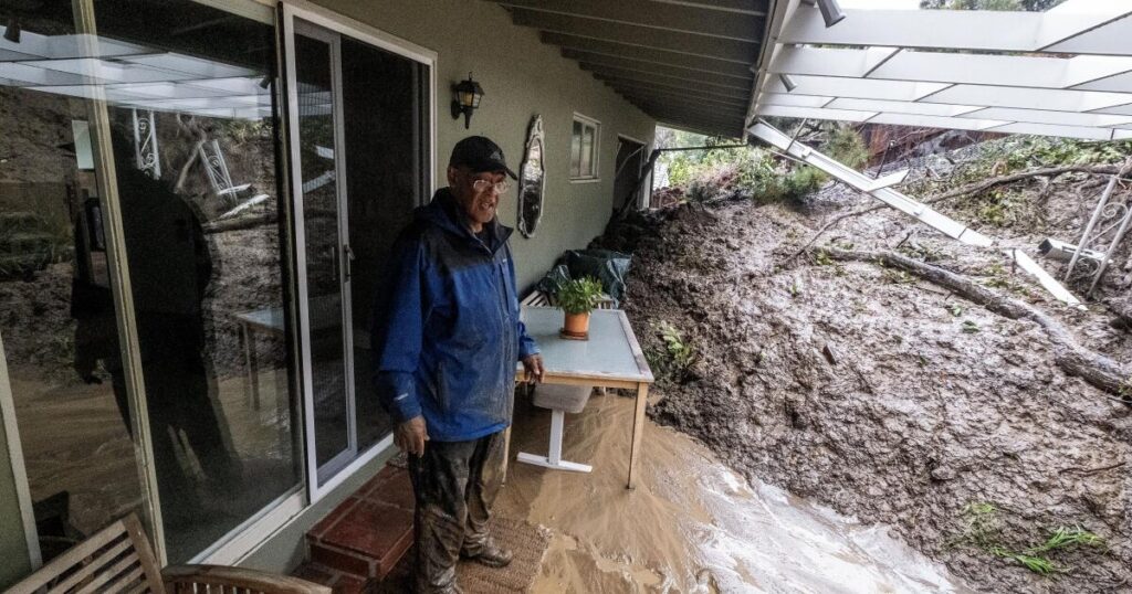
For Southern California, it would mean a higher chance of above-average rainfall, risking a winter of flash floods and landslides.
During three of the four “very strong” El Niños in the global record, downtown Los Angeles got significantly more rain than average. In two — 1982-83 and 1997-98 — downtown L.A. got more than double its usual yearly rainfall.
But the connection is not absolute. During the last “very strong” El Niño in 2015-16, downtown got only half its typical annual rainfall.
The last El Niño, in 2023-24, was a “strong” one. For the water year that ended Sept. 30, 2024, downtown L.A. got 22.15 inches of rain to downtown Los Angeles — that’s 155% of of the average annual rainfall of 14.25 inches. That winter brought with it hundreds of landslides across Los Angeles and the second-rainiest three-day period for downtown L.A. since recordkeeping began in 1877.
There was also well-above average rainfall across coastal Southern California and slightly above-normal precipitation in coastal Northern California, the state Department of Conservation said.
But not all of California got the bounty of precipitation during that El Niño. There was below-normal precipitation in interior areas like the Sierra Nevada and southeastern California deserts.
More high-tide flooding is also possible in an El Niño. The “very strong” El Niño of 2015-16 brought “record coastal erosion along many California beaches,” the state Coastal Commission said.
This year’s El Niño is also expected to prolong an already existing marine heat wave — currently in effect for reasons unrelated to El Niño — off the Southern California coast.
What about warming ocean waters?
Scientists are raising alarms over the planet’s warming oceans. El Niño typically increases global temperatures, the World Meteorological Organization said, and high sea-surface temperatures can “intensify heat extremes over nearby land areas.”
“An El Niño event is a source of heat for the atmosphere, increasing global temperature and shifting weather patterns across the globe,” the World Meteorological Organization said.
On July 1, officials confirmed that the global sea surface temperature in June hit a record for this time of year.
“Current conditions could indicate the beginning of a new phase, leading, once more, to uncharted territory. With ocean temperatures at these levels and El Niño on the horizon, we are likely to see more temperature records fall in the coming months,” said Carlo Buontempo, director of the Copernicus Climate Change Service, an arm of the European Union.
Warming ocean waters have wide-ranging effects, scientists say. They can provide extra energy to storms and increase evaporation, boosting the chance for extreme precipitation and flooding; contribute to sea level rise; exacerbate ice melt and stress marine ecosystems, according to a statement from the Copernicus Climate Change Service and Copernicus Marine Service.
The post A ‘super’ El Niño is brewing. Experts fear historic dangers from extreme weather appeared first on Los Angeles Times.