Tornadoes were reported in Illinois and Wisconsin on Wednesday evening as intense storms roared across the Midwest, delivering bursts of heavy rain and large hail and generating damaging winds that snapped trees and power lines.
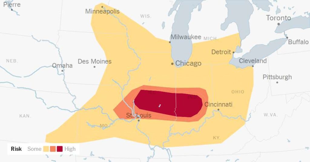
The threat of severe weather was expected to continue through the evening for millions of people from Kansas into Ohio — including Chicago, Indianapolis and St. Louis. The highest threat was focused over an area spread between eastern Missouri, central Illinois and western Indiana, where tornado watches were in effect.
More urgent tornado warnings also dotted the region, including several that the National Weather Service called a “particularly dangerous situation,” a rare designation for especially hazardous tornado conditions.
One tornado in Charleston, Ill., caused some damage to buildings around 7 p.m., local media reported, and significant tree damage blocked roads.
Andrew Lyons, a meteorologist at the Storm Prediction Center, said there was a “high probability” of long-lasting, highly organized supercell thunderstorms forming and bringing the potential for tornadoes into the evening. These thunderstorms were forming in Illinois, Iowa and Wisconsin and expected to move into Indiana through the evening.
While the threat of tornadoes loomed, Mr. Lyons said the bigger concern was widespread damaging winds that could reach speeds over 75 miles an hour.
The wind was already evident during the early morning storms in Iowa and Illinois. Before midday, there were more than 25 preliminary wind reports that had damaged trees and power lines across the region. The Storm Prediction Center said significant wind gusts over 80 m.p.h. had already been recoded before sunrise, including a wind gust of 94 m.p.h. in Marshall County, Iowa.
Wednesday’s storms were expected in some of the same areas that were hit by damaging winds and tornadoes during an outbreak last week. On June 10, a line of thunderstorms produced a derecho, or winds that can be as destructive as a tornado but that move in a straight line instead of a rotation. Wind gusts up to 85 m.p.h. led to widespread damage across Northern Illinois.
The next day brought more storms and at least 20 confirmed tornadoes to the same region. At least two of the tornadoes — one in Streator, Ill., and another in Hebron, Ind. — were rated a three on the five-point enhanced Fujita tornado scale. A storm that day also toppled what is believed to have been the last surviving “witness tree” at Abraham Lincoln’s former home in Springfield, Ill.
The severe weather threat in the region is expected to be short-lived. By Thursday, some rough weather could move into the Northeast and Mid-Atlantic states. “We’re not expecting an outbreak again,” said Jared Guyer, a meteorologist at the Storm Prediction Center, “but there will be the risk of some severe storms.”
This is the time of year for severe storms
Forecasters often know up to a week in advance whether conditions are likely to be favorable for thunderstorms, but their ability to pinpoint exactly where and when those thunderstorms kick off is much more limited. Read more about why forecasting thunderstorms is still so hard.
Scientists have been able to draw links between a warming planet and many types of extreme weather, including hurricanes, heat waves and droughts. But they are not yet able to determine whether there is a link between climate change and the frequency or strength of tornadoes. Read more about tornadoes and climate change here.
How to prepare
The post Tornadoes Reported in Wisconsin and Illinois as Violent Storms Move Through Midwest appeared first on New York Times.