A batch of severe thunderstorms in central portions of the United States are expected to continue through Sunday, before peaking with the most widespread and impactful conditions.
Aaron Gleason, a meteorologist at the Storm Prediction Center, said that some of the storms, especially on Monday, were likely to become supercells — the most dangerous type of thunderstorms, which can last for hours. Those storms are expected to produce hailstones as large as softballs; damaging wind gusts over 75 miles per hour; and several powerful tornadoes, particularly across parts of Kansas and Nebraska.
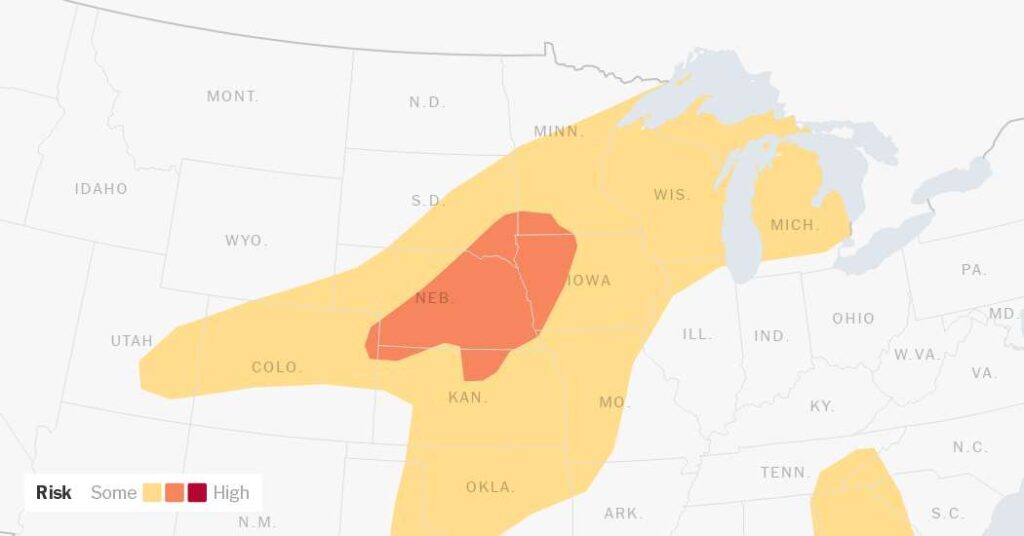
Some areas face an elevated risk of severe weather. The National Weather Service advised people in areas threatened by thunderstorms to closely monitor watches and warnings, especially those for tornadoes.
A tornado watch means conditions are favorable for tornadoes to develop. More urgent is a tornado warning, which means people should seek shelter immediately because a tornado is either about to form or already has.
The repeated rounds of thunderstorms are also expected to increase the risk of flash flooding. An area from northeast Kansas into southwest Iowa faces the highest threat for repeated storms and heavy rainfall on Monday, the Weather Prediction Center said, as storms move over locations that experienced rain on Sunday.
Here’s a day-by-day look at what to expect.
Sunday:
-
Severe storms are expected to develop from Sunday afternoon and continue into the night across the Central Plains and Upper Midwest.
-
The first storms are expected to form across northeast Colorado and southwest Nebraska before spreading eastward into Nebraska, Kansas, Iowa and nearby states through the evening and overnight.
-
Some of those storms could become supercells capable of producing very large hail up to 3 inches in diameter.
-
Wind gusts could exceed 75 miles per hour and a few storms may also produce strong tornadoes.
-
Some storms are expected to merge into clusters or lines as the evening progresses, the Storm Prediction Center said. That could reduce the tornado threat, but also increase the risk of widespread damaging winds.
-
Isolated severe storms may also develop farther south across Oklahoma, North Texas and parts of Kansas. Any storms that form there could produce very large hail and damaging winds.
-
Parts of Illinois, Wisconsin and Michigan may also experience a few severe storms.
Monday:
-
Monday is expected to be the most significant day, with the most widespread and impactful severe weather forecast across the Central and Southern Plains and parts of the Midwest.
-
Storms are expected to develop by late Monday afternoon, especially near central Kansas, and are forecast to rapidly intensify into supercells capable of producing intense tornadoes and giant hail up to 4 inches in diameter or larger.
-
The tornado threat is greatest from central Kansas into northeast Kansas and southeastern Nebraska, according to the Storm Prediction Center.
-
Farther northeast into Iowa, Illinois, Indiana, Wisconsin, Kentucky and lower Michigan, severe thunderstorms may develop Monday afternoon and evening. They could bring hail and damaging wind gusts of 75 miles per hour.
-
Some severe storms are also possible across portions of Oklahoma and Texas, where there remains a threat for very large hail and isolated tornadoes, although the forecast there was less certain.
The days-long severe weather outbreak began on Saturday, when the storm threat was greatest across parts of the Central Plains and Midwest.
By late Saturday afternoon, thunderstorms had developed across portions of southern Iowa, northern Missouri and western Illinois, with reports of lightning, golf-ball-sized hail and knocked down trees. Storms were also reported across parts of northeast Colorado, southern Nebraska and northern Kansas.
The severe weather threat is expected to ease on Tuesday, though storms will still be possible. Mr. Gleason, of the Storm Prediction Center, said hail and damaging winds could threaten central parts of the United States.
“But it’s mostly just a line of storms and maybe some hail, and seemingly a lower tornado threat from Michigan all the way down to Texas,” he added.
Nazaneen Ghaffar is a Times reporter on the Weather team.
The post Powerful Storms, Hail and Tornadoes Forecast for Central U.S. appeared first on New York Times.