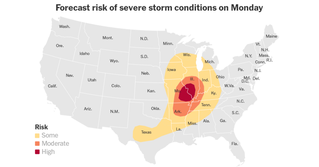
A powerful spring storm is expected to spark several rounds of severe weather in parts of the Midwest on Monday. Forecasters warn that strong tornadoes, damaging wind gusts and hail as large as baseballs are all possible, especially across parts of Missouri and Illinois.
The threat has continued for several days, but Rich Thompson, the chief of forecast operations at the Storm Prediction Center, said Monday is expected to be the most intense day. He said the greatest number of storms, and the highest concentration of severe weather, is expected to occur across more densely populated areas, increasing the potential for damage and disruption.
Storms that began late Sunday evening were still active on Monday morning across parts of Kansas and Missouri, including around Kansas City and Topeka. Mr. Thompson said these storms are expected to continue moving eastward, while additional storms are expected to develop later in the day. Together they are expected to bring a “substantial tornado risk,” especially across areas of Missouri and Illinois, where the Storm Prediction Center had a level four out of five risk for severe weather on Monday.
“East, central and southeast Missouri and into parts of central and southern Illinois seem to be at the highest risk for strong tornadoes later today,” he said. “And that would potentially include the St. Louis area.”
In addition to the risk of tornadoes, a broader area stretching from the Mississippi Valley into the lower Ohio Valley faces a lower, but notable, threat of severe weather. People in this region, which includes Chicago, Nashville and Milwaukee, could face damaging wind gusts of up to 70 miles per hour and hail up to three inches in diameter.
Some areas may also face flash flooding. Northern and central Missouri, along with much of Illinois and Indiana, are at particular risk. Forecasters at the Weather Prediction Center said repeated rounds of storms on Monday could produce rainfall rates of up to two inches per hour, especially early Monday over northern Missouri, which may lead to flash flooding.
The severe weather outbreak is part of a broader stretch of active and dangerous weather that has unfolded over recent days. Since Thursday, parts of the Plains and the South have recorded more than 50 tornado reports. Among them was a preliminary EF4 tornado — level four on a five point scale — in Enid, Oklahoma. North Texas was also hit by severe storms producing hail the size of tennis balls and winds gusts up to 89 miles per hour, killing at least two people and displacing dozens of others.
The severe weather threat is expected to ease slightly on Tuesday. Mr. Thompson said it will be a “step down” in intensity, with the tornado risk shifting south, toward North Texas and parts of southern and eastern Oklahoma.
“So just a typical severe weather threat for late April,” he said. “And then the severe weather threat should slowly decrease after that.”
Nazaneen Ghaffar is a Times reporter on the Weather team.
The post Severe Storms Expected Across the Midwest on Monday appeared first on New York Times.