More than 125 million people across a large portion of the United States are facing a threat of severe weather that could include heavy rain, tornadoes, strong wind and hail on Tuesday afternoon and evening.
The severe weather is part of a multiday breakout of storms that forecasters expect to last through the weekend.
On Monday night, tornadoes were reported across Kansas, Minnesota and Iowa. One hit the city of Ottawa, Kan., shortly before 8 p.m. on Monday, Adam Weingarten, the police chief, said in an interview with the local television station KSHB. The tornado damaged several businesses and homes, he said. On Tuesday, the local authorities were still surveying the damage, but said no one had been killed.
The severe weather is being fueled by a steady supply of warm, moist air from the Gulf of Mexico, that is combining with a daily parade of weather systems moving across the country. It is typical for this time of year, said Jared Guyer, a meteorologist at the Storm Prediction Center.
But predicting where, exactly, a typical springtime storm will turn into something more dangerous — by producing a tornado or a torrent of rain that turns into a flash flood — can be difficult. (Read more here about how thunderstorms form.)
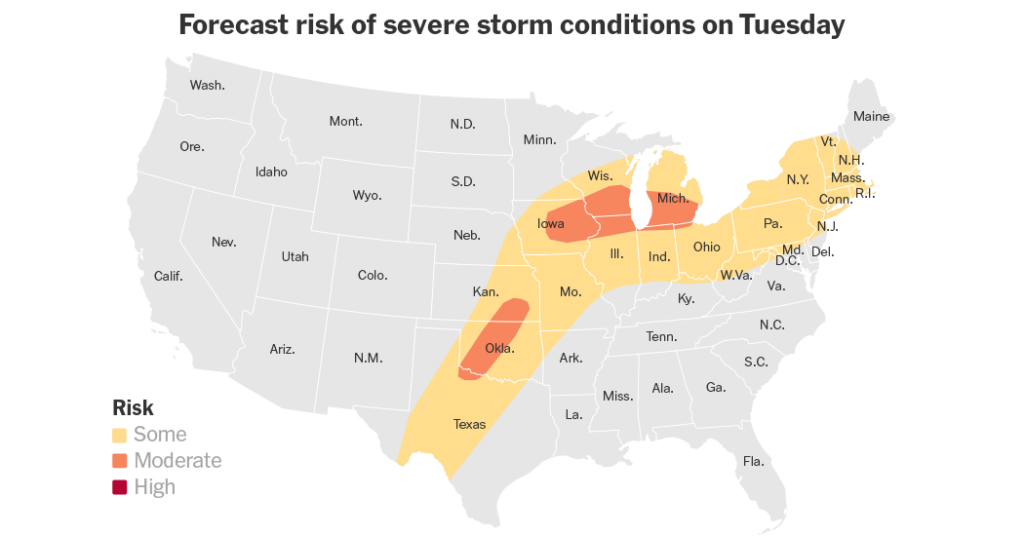
On Tuesday, forecasters at the Storm Prediction Center said the most significant risk fell in a bull’s-eye-shaped area of the Upper Midwest, and included the cities of Chicago, Milwaukee, Des Moines and Minneapolis. A separate area is centered over Texas, Kansas and Oklahoma, including Oklahoma City and Wichita, Kan. Forecasters are also closely watching a part of the Northeast that includes parts of New York, Vermont, New Hampshire and Massachusetts. Numerous thunderstorms are possible across the Midwest. Forecasters said there was a medium probability that the worst storms were likely to occur in a corridor between Des Moines and Milwaukee.
If a tornado does form on Tuesday, forecasters are most concerned that it could be the strongest in that same corridor north of Chicago, which includes some heavily populated suburbs.
It is not just tornadoes. There is a risk of “giant hail,” forecasters said on Tuesday afternoon, both in the Midwest but also in the Southern Plains, including Oklahoma City.
But there is some chance of storms across a huge area of the country from Southwest Texas up to the Great Lakes and east to New York and Philadelphia.
Forecasters are also concerned that a combination of high rainfall rates and repeated rounds of storms may also lead to flash flooding. The Weather Prediction Center said that on Tuesday there was an elevated risk of flash flooding around the Great Lakes, including parts of Wisconsin, Michigan, Indiana and Illinois.
In Michigan, the authorities were increasingly worried about rising water levels at the Cheboygan Dam near Lake Huron. Gov. Gretchen Whitmer declared a state of emergency on Friday as melting snow and heavy rain sent water levels rising at the dam. And on Monday, the Cheboygan County Sheriff’s Office warned residents to be prepared to evacuate. More rain was expected in the area this week.
How to prepare
Erin McCann is the deputy editor for The Times’s Weather team. She is based in San Francisco.
The post Central U.S. Braces for Yet Another Wave of Severe Storms appeared first on New York Times.


![AEW’s Kenny Omega Gives Update on Kota Ibushi’s Recovery [Exclusive]](https://dnyuz.com/wp-content/uploads/2026/04/IMG_5301-350x250.jpeg)