At 4:30 a.m. on a recent Wednesday, three alpine scientists arose from fitful sleep in a chilly research lab in the Colorado mountains, 11,500 feet above sea level. They drank some grainy coffee, strapped into their skis and headed out into the moonlight, dragging a sled loaded with gear.
They had a satellite to meet.
The scientists were on an unusual mission. They needed to measure the depth of the snow at a particular mountaintop location just as a new satellite passed directly overhead. That satellite, equipped with powerful radar, has the potential to be the first one capable of estimating how much water is on the ground, in the form of fallen snow, from outer space.
It would be an extraordinary technological milestone, providing global data on snowpack, precipitation and how much water might be available to feed rivers and reservoirs downstream in spring and summer. But first, the satellite would need to be calibrated.
And one of the most accurate ways to do it is to be physically present on the mountain to measure the snow under the exact same conditions, and at the exact same time, that the satellite does. Other scientists are doing similar things around the world.
Precise timing matters. Snow changes quickly and the satellite passes over the same spot only once every 12 days.
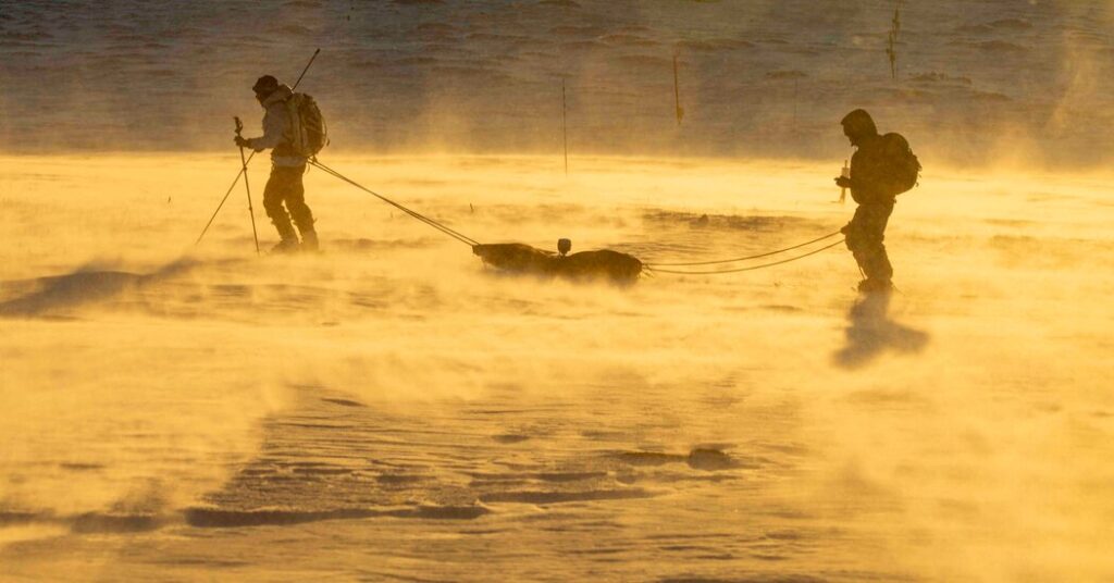
So with hearts pounding from the thin alpine air the three skied out onto moonlit snow. Two of them towed the sled, equipped with a small portable radar that is capable of measuring the snow’s depth and density simply by dragging it back and forth across the mountainside.
“Only 4 centimeters deep here!” one of the scientists, Emma Tyrrell, called out. She was leading the project as part of her Ph.D. at the University of Colorado and the Institute of Arctic and Alpine Research. At the back of the sled, helping her pull it, was Arielle Koshkin, a postdoctoral researcher in the same lab, who made a note of the measurement.
For two hours, Ms. Tyrrell and Dr. Koshkin skied back and forth in precise zigzags across the slope of the ridgeline, pulling the radar with them and plunging a ruler into the snow every few feet. Somewhere, invisibly above them, the satellite charted its own path across the sky.
The satellite, known as NISAR, was launched last summer by National Aeronautics and Space Administration and the Indian Space Research Organization. The satellite’s capabilities are the closest humans have come to measuring water content in snow across vast regions, from space, the holy grail of snow science.
The new technology comes at a critical time. As the world warms, snow is vanishing across many parts of the planet. That includes Western United States, which is currently undergoing a record snow drought. In states including Colorado and Utah, the snowpack is the lowest since comprehensive modern recording began, 40 years ago. That’s a problem because these states rely on snow melt for up to 80 percent of their water.
Snowpack, Ms. Tyrrell said, acts like a frozen water tower, storing and releasing water that then gets used by communities and farms downstream throughout the year. She paused to gesture across the mountain peaks, where the snow was visibly patchy and thin.
The area she was working, known as Niwot Ridge, would typically be blanketed in a thick layer of snow this time of year. The area is part of a watershed that provides a third of the water needed by the city of Boulder, which was visible that morning, some 25 miles away, as cluster of twinkling lights.
The warming world will doubtlessly transform Colorado, but because of the state’s high elevation there’s uncertainty about precisely how that might play out, Dr. Koshkin said, speaking as she helped Ms. Tyrrell adjust a GPS sensor on the top of the sled. Some precipitation might fall as rain instead of snow, but rain doesn’t remain stored on the mountainside to steadily provide meltwater later in the year. She also said the swings between good and bad snow years are likely to become more drastic.
The sun had started to rise, tinting the mountains scarlet. Several dozen yards away, Millie Spencer, a Ph.D. candidate in the same research group helping out on the day’s mission, was digging a snow pit with a shovel.
This old-school approach remains the gold standard for accurate data on snow. Even when working with modern technologies, like the sled radar, scientists often take analog measurements from snow pits at the same time.
Water managers still rely on long-term records from manual snow measurements to predict how much water to expect from snow each year, from which they create complex forecasting models that patch together different kinds of data. Perhaps most important of these is a large federally run network of snow-weighing sensors that take daily measurements across Western states.
But these sources capture only conditions at a single, isolated point. That’s a problem, because snow can vary significantly across even a short area. And as snow vanishes from the places it used to fall, scientists and water managers say these methods will become less reliable.
The new satellite has some important caveats. It can’t measure snow in densely forested areas, or if the snow becomes too wet. And the satellite’s radar doesn’t always strike Earth at an optimal angle for snow measurements.
The problem is that it wasn’t designed or intended to measure snow, said Jack Tarricone, a scientist at the University of Maryland and NASA. The original mission, first proposed more than two decades ago, was to monitor crops and a variety of other Earth systems like natural disasters, tectonic activity and glaciers.
While the new satellite may be no silver bullet, it’s the best chance scientists have had to measure snow on a wide scale. Researchers at universities and federal agencies alike said they had spent years anticipating the satellite and preparing for its launch.
Now, the clock is ticking. Satellites often stay up well past their intended life spans, but the snow-measuring radar on this one is planned to operate for only three years.
That’s one reason Ms. Tyrrell felt urgency to do these calibration measurements now. Other teams of scientists are also taking measurements at other locations around the world, using a variety of different techniques, to give the satellite the best chance of being accurately calibrated against differing locations and geographical conditions.
Some are flying helicopters and drones with laser scanning devices, other are using radars like Ms. Tyrrell. Each method has pros and cons, but for all its scientific benefits, dragging a sled is certainly hard and slow going.
After several hours, around 7:30 a.m., Ms. Tyrrell and Dr. Koshkin started wrapping up for the day. The satellite had moved on.
They dragged their radar sled back toward the mountainside lab while Ms. Spencer, still working on her snow pit, struggled to examine lumps of snow crystals with a magnifying glass. The task was made nearly impossible by the ribbons of sleet pelting her face.
Back at the shed, Ms. Tyrrell unzipped the cloth covering over the radar and spotted a problem. Snow had somehow gotten onto the device. Worse, one of its many wires had become unplugged.
But there was nothing to be done. It was probably fine, Dr. Koshkin reassured her. The device was made for snow, after all. And most likely the wire fell out as they hauled it indoors.
Next would come a harrowing 45-minute drive back down the mountain in an open-air vehicle with caterpillar treads. Fully checking her data would have to wait until she was back in Boulder. Either way, she said she intended to try again when the satellite comes back in a couple weeks, as long as the snow doesn’t melt in the meantime.
That’s just the nature of studying snow. “There’s only so much you can control,” she said. “We have to work with what we’ve got.”
Sachi Kitajima Mulkey covers climate and the environment for The Times.
The post How Do You Measure Snow From Space? First, Climb a Mountain. appeared first on New York Times.