A powerful weather system was sweeping across the Eastern United States on Monday, disrupting travel and school as it brought the potential for widespread storms.
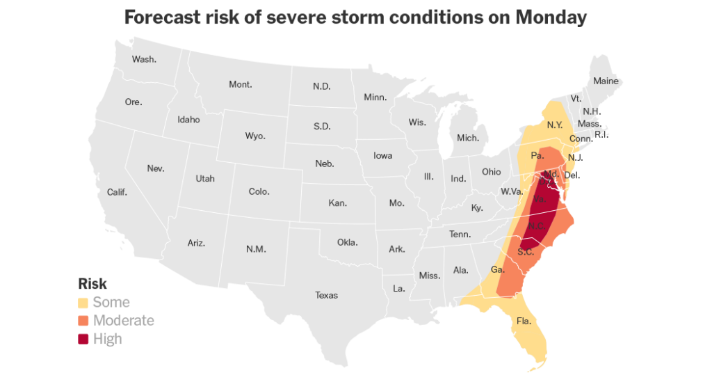
By midday, more than 34 million people were under an almost continuous patchwork of tornado watches — meaning the conditions were in place for tornadoes to form — from Florida to New Jersey, including Washington. More urgent tornado warnings are likely throughout the day, with the most severe storms expected in the afternoon and evening.
Hundreds of flights at airports in Atlanta, Charlotte and Washington were delayed or canceled by early afternoon, according to FlightAware, an airline tracking site.
Several school districts across Maryland, D.C. and Delaware announced early dismissals and closures because of the weather on Monday.
The area of greatest concern stretches from northern South Carolina northward into Maryland, according to Evan Bentley, a meteorologist at the Storm Prediction Center.
“And the two primary threats will be damaging winds and the threat of tornadoes,” he said. “But we are also really concerned about just how large of a population will be impacted.”
On Sunday, the same system swept over parts of the Mississippi, Ohio and Tennessee valleys, producing damaging winds of more than 60 miles per hour that downed trees and damaged buildings, along with hail as large as tennis balls. A tornado was also reported in Arkansas.
The system moved east of the Appalachian Mountains overnight, and stormy weather was affecting a long band of the Eastern U.S. on Monday morning.
Across a wider region of the East, from Florida to southern New York, severe storms are expected to be more isolated. But Mr. Bentley warned that any storms that do develop could still be just as intense as those in the higher risk area, and advised people in those areas to stay aware of the forecast.
While not the primary concern, some large hail is also possible, particularly farther south, across the Carolinas and into parts of southern Georgia and northern Florida.
The system is expected to begin moving offshore late Monday evening, gradually reducing the risk of severe weather into Tuesday.
After that, Mr. Bentley said, “It looks like we will have a multiday break from the severe weather,” which over the last few weeks has brought a chaotic and deadly mix of high winds, hail, tornadoes and even a late-winter snowstorm.
Nazaneen Ghaffar is a Times reporter on the Weather team.
The post Sprawling Storm System Brings Threat of Tornadoes Across the East Coast appeared first on New York Times.