A strong storm system is expected to bring severe weather across a broad area of the United States, from the Midwest to the East Coast, on Sunday and Monday.
All manner of severe weather could be in the mix, including damaging winds in excess of 75 miles per hour, hail larger than golf balls, and strong tornadoes. Memphis; Columbus, Ga.; and Washington, D.C. are among the cities at risk of tornadoes.
The new threat of severe weather comes after an active start to the storm season. In recent weeks, storms killed at least six people in Michigan and Oklahoma, and two people in Indiana.
Here’s a day-by-day look at what to expect:
Sunday
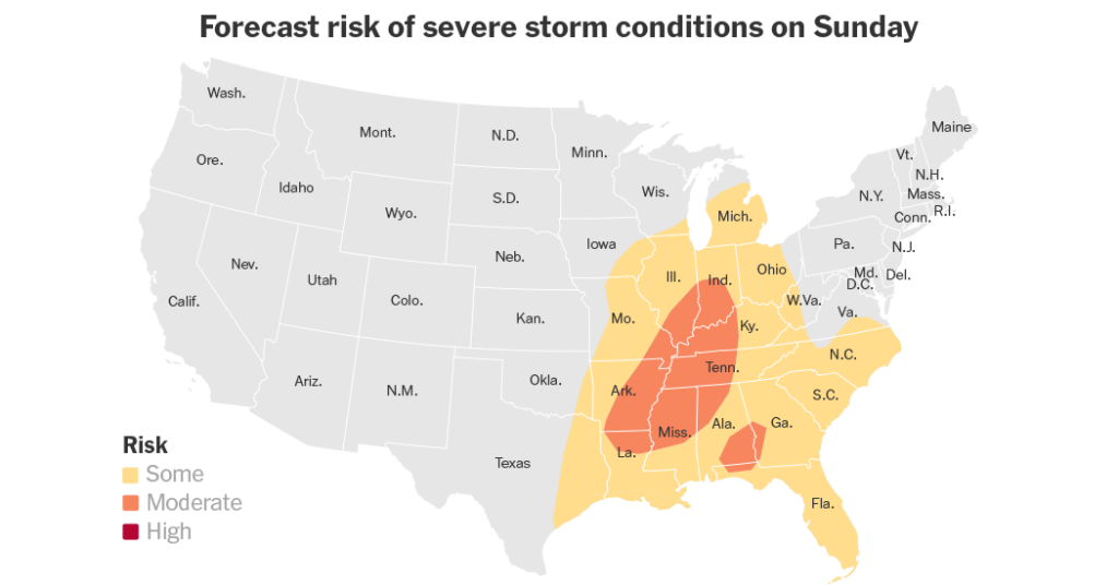
Severe storms are expected across parts of the Mississippi, Ohio and Tennessee valleys on Sunday, arriving as early as the afternoon, with the threat continuing into the night.
“We expect a squall line to develop across part of the Midwest and spread south-southeastward through the evening and into the overnight hours,” said Andrew Lyons, a meteorologist at the Storm Prediction Center.
Memphis, Nashville, Indianapolis and Louisville, Ky., could all fall within the line of some of the most intense storms.
The Storm Prediction Center warned that approaching storms might be difficult to see in the overnight hours and advised that people living in those areas “have multiple ways to be notified of severe weather warnings.”
While the storm threat extends across a large area, from eastern Texas to Ohio, the highest chance of the most extreme weather stretches from parts of Arkansas, Louisiana and Mississippi into the lower Ohio Valley. A small area of the western Florida Panhandle, southeastern Alabama and southwest Georgia are also under a high risk of severe weather.
Smaller portions of those areas, including Memphis and Columbus, Ga., fall within the bull’s-eye of the highest risk of tornadoes — with a 10 percent chance.
John Hart, a meteorologist at the Storm Prediction Center said that a line of thunderstorms was expected to march through the area after sunset on Sunday.
“From 4 p.m. to 9 p.m., somewhere in that time zone, is the maximum concern for the Memphis area,” he said.
Mr. Hart added that damaging wind gusts were the primary concern within the line of storms, but any tornadoes that form would have the potential to be as strong as a 2 on the 5-point Enhanced Fujita scale in the Memphis area.
Monday
As the strong storm system moves east of the Appalachian Mountains on Monday, the threat of severe weather shifts to the East Coast, in an area spread between southern New York and Florida.
The area at highest risk stretches between South Carolina and Maryland, including Washington, Raleigh and Richmond.
The Weather Service office serving Washington said winds more than 80 m.p.h. and a few tornadoes are possible in the greater D.C. area.
The same severe weather risk area is at the highest potential for strong tornadoes and damaging winds on Monday, according to the Storm Prediction Center.
Mr. Hart said the risk of severe storms would begin late Monday morning and last through the afternoon, before the system eventually moves offshore.
“Then it would appear, in terms of severe thunderstorms, there will be quiet weather across the United States for several days,” he said.
Amy Graff is a Times reporter covering weather, wildfires and earthquakes.
The post Widespread Severe Storms Threaten the Southeast and Midwest appeared first on New York Times.