A potent, long-lasting storm that flooded roads, toppled trees and closed schools across the Hawaiian Islands continued to drench the region and whip up strong winds on Saturday, with the hazardous weather expected to continue through Sunday.
Flash flooding forced evacuations on the North Shore of Oahu, in the small community of Otake Camp in Waialua, on Friday, according to alerts from the Oahu Department of Emergency Management.
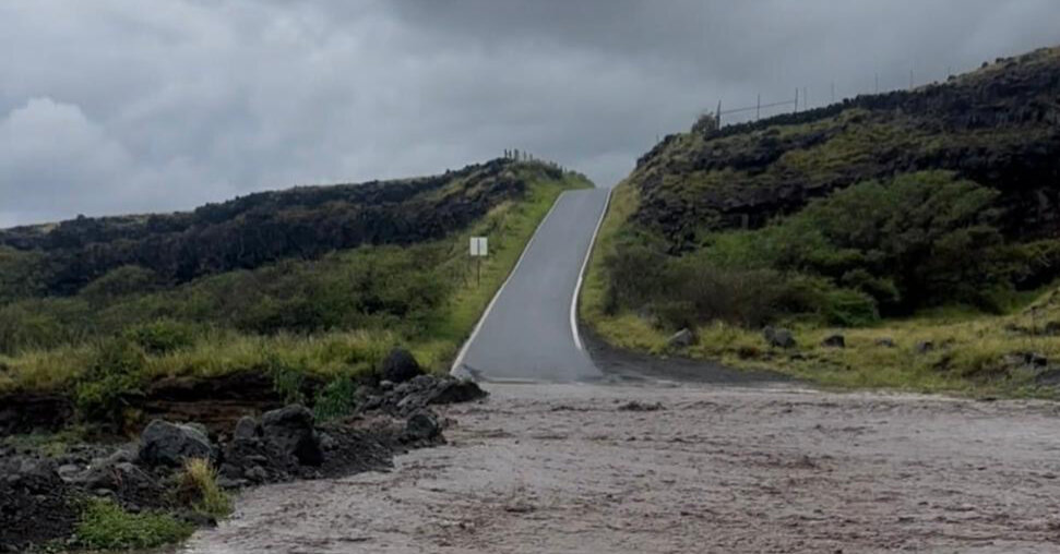
Landslides have been among many hazards brought on by the storm. Robert Bohlin, a meteorologist with the National Weather Service in Honolulu, said there have been too many landslides to count, and “there will be more.”
Water was pooling on roads as heavy rain fell on soils saturated by precipitation since Tuesday.
“There’s nowhere for the water to go except runoff,” said Patrick Blood, a meteorologist with Weather Service office in Honolulu. “We don’t need any more rain because we already have flooding, trees on power lines, power outages.”
Since Tuesday, Honolulu had recorded more than 10 inches of rain. In an average March, the city records 2.36 inches of rain, according to Weather Service data.
In the last 24 hours alone, rainfall totals across the Islands have been staggering. The wettest locations recorded more than 12 inches on Oahu, and more than 23 inches on Maui, as of early Saturday morning.
The Weather Service said on Saturday that the storm will be focused over Maui and the Big Island. Flash flood warnings were in effect on these islands, with flooding on streams, rivers, roads and in low-lying areas possible.
A flood watch and a high wind warning remained in effect across the entire state on Saturday.
Gov. Josh Green of Hawaii announced that public schools, state offices and University of Hawaii campuses were closed on Friday because of the severe weather.
Hawaiian Electric said on Saturday that it was working to restore power to 111,000 customers on Oahu, the Big Island and Maui.
The storm had also brought snow to the Island’s two tallest mountains, Mauna Loa and Mauna Kea on the Big Island.
A winter storm warning was in effect through Monday, with winds greater than 100 miles per hour expected to whip up blizzard conditions.
Snow falls frequently on these volcanic peaks of more than 13,000 feet in elevation during winter storms, but this system is expected to bring unusually high snowfall totals, with more than 20 inches possible.
Forecasters in Hawaii call the type of storm that’s pummeling the Islands a Kona low. These seasonal storms are not uncommon during the rainy season, which runs from November through April, but this week’s system is particularly strong.
“These Kona storms come in different flavors but they are some of the most damaging storms,” Mr. Bohlin said. “They can do the sort of damage that a hurricane can do. This is one of the higher end ones.”
These storms generate winds from the south and southwest that affect the leeward (or Kona in Hawaiian) sides of islands. The leeward sides are typically the drier sides, as the more common trade winds that blow from the east and northeast bring moisture to the windward sides.
Honolulu, where the majority of the population in Hawaii lives and where tourists go to visit Waikiki Beach, is on the leeward side of Oahu and usually protected from the moisture-heavy trade winds by the Koolau Mountains.
With this storm, the lashing rains have been reaching Waikiki.
“It’s not a beach day in Waikiki today,” Mr. Blood said on Friday. “This is a horrible week to come to Hawaii.”
The chance for rain continues next week, but the weather is likely to be less extreme as the Kona low that has been anchored to the Islands is finally expected to begin moving northeastward on Sunday and into Monday.
Amy Graff is a Times reporter covering weather, wildfires and earthquakes.
The post Rains Inundate Hawaii, Closing Schools and Causing Landslides appeared first on New York Times.