Storms were dropping heavy rain and large hail and threatening to spin off tornadoes across a large section of the Central United States on Tuesday afternoon, as people from Texas to the Great Lakes were facing an afternoon and evening brimming with the potential for dangerous weather.
By the afternoon, tornado watches were in place in parts of Texas, Oklahoma (including Oklahoma City) and Illinois, a signal to residents that the ingredients were in place for tornadoes to form. Some brief warnings were also issued in Texas and Illinois as tornadoes were reported, but there were no immediate reports of damage.
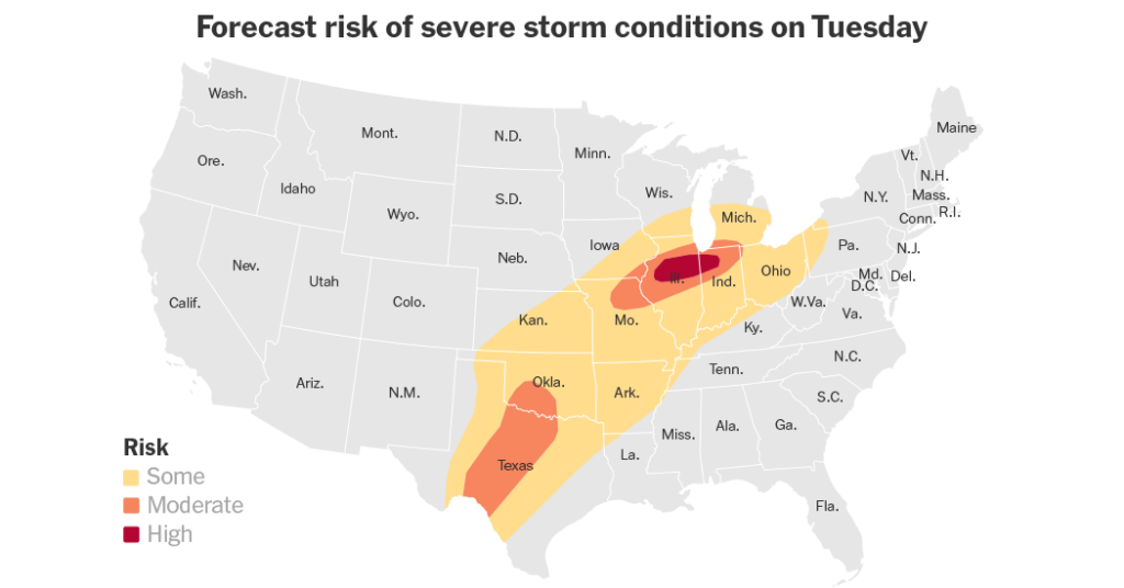
Even Chicago falls within an area under the threat of tornadoes. The risk there is very low, only 2 percent, but at this time of year, any tornado threat in the city is unusual.
Scott Baker, a meteorologist with the National Weather Service office in Romeoville, Ill., said the bigger concern in the city was wind gusts that could reach over 50 miles per hour, even stronger. Winds this strong can knock over trees. Another concern is hail as large as quarters, or even limes, he said.
The larger threat of tornadoes in the Chicago area falls south of the city, especially areas south of Interstate 80.
“To have this much instability in the atmosphere this early in March, I would say that’s uncommon,” said Mr. Baker “This weather is more typical of late summer or maybe an early summer pattern.”
The renewed threat of severe weather comes just days after a wave of storms swept the same region on Friday, producing tornadoes that killed at least six people in Michigan and Oklahoma.
The most intense weather is forecast in two separate areas.
All told, more than 70 million people live in an area at some risk from these storms. And while severe thunderstorms are possible from Texas to western Pennsylvania, two areas are at an enhanced risk, with higher chances of extreme weather including intense tornadoes.
One of these areas was spread across a portion of Texas, including Fort Worth, and Oklahoma. The other area at risk was centered in the Midwest from northeast Ohio, across Central Illinois and northern Indiana, and includes Chicago.
If there are tornadoes on Tuesday, this is where they are most likely to form, forecasters said. The area is also at risk of hail large enough to damage cars.
The City Council in Peoria, a town of about 115,000 people about 160 miles southwest of Chicago, canceled a meeting scheduled for Tuesday evening because of the weather.
Forecasters said the storms could deliver wind gusts exceeding 60 miles per hour and hail larger than two inches in diameter, in addition to strong to severe tornadoes.
Matt Mosier, a meteorologist at the Storm Prediction Center, said the storms are part of a “fairly typical spring setup,” when warm, moist air surges north from the Gulf of Mexico and meets with passing weather systems. That interaction often produces multiple rounds of storms across the Mississippi Valley, with active periods followed by brief lulls before the cycle repeats. But pinpointing exactly where and when they will hit is difficult.
The storms are also expected to bring the risk of flash flooding, particularly across portions of the central United States, from the Plains toward the southern Great Lakes on Tuesday and Wednesday.
What comes next:
Wednesday
-
The threat shifts east, in a broad area from eastern Texas and Louisiana through to Pennsylvania, including areas of Arkansas, Mississippi, Alabama, Tennessee, Kentucky, West Virginia, Virginia, Indiana and Ohio.
-
All severe weather types are again possible, including widespread wind gusts that could cause damage, large hail and tornadoes.
-
Isolated flash floods are possible over areas of northeast Texas, northern Louisiana, northern Mississippi, Arkansas, southeast Oklahoma, southeast Missouri, western parts of Tennessee and Kentucky and Southern Illinois.
Thursday
-
Mr. Mosier said the threat of severe weather would be on a “downward trend” from the middle of the week, though some severe weather may continue over areas of the Mid-Atlantic and Southeast on Thursday.
Mitch Smith contributed reporting.
Nazaneen Ghaffar is a Times reporter on the Weather team.
The post Tornado Watches in Illinois, Texas and Oklahoma as Intense Storms Move In appeared first on New York Times.


