The planet may experience a strong or even a super El Niño later this year, one that could rival the strongest ones in history, according to new climate data recently released by the European Center for Medium-Range Weather Forecasts (ECMWF).
A typical El Niño affects regional-to-global weather patterns, as a warming patch of water in the equatorial Pacific Ocean influences what regions could experience droughts, floods and extreme heat. During these relatively rare super El Niño events, happening once every 10 to 15 years on average, the effects may be stronger, more persistent and more widespread.
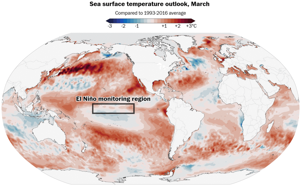
That’s because sea temperatures in that key region of the Pacific Ocean warm more than 2 degrees Celsius above average, leading to a profound atmospheric response.
Those impacts can include the frequency and location of heat waves, the locations of flooding downpours and drought could focus, where hurricanes may hit, and declining sea ice concentrations. For example, the Western United States could face a hotter than average summer, some tropical countries could face worse drought and extreme heat, while more tropical cyclones could develop in the Pacific, with fewer in the Atlantic.
There’s also a growing chance that this year’s El Niño, especially if it’s a strong one, would push global temperatures to record levels, particularly in 2027.
It’s a possibility that has the attention of climate scientists, though there are a range of views on how strong it may become.
“Whew,” wrote climate scientist Daniel Swain last week in a post on X. “All signs are increasingly pointing to a significant, if not strong to very strong, El Niño event.”
Whew. All signs are increasingly pointing to a significant, if not strong to very strong, El Niño event. I’ll have more to say in coming weeks & months, but for now I’ll just say that this is increasingly likely to become a major regional-to-global climate driver in 2026-2027. pic.twitter.com/eHci7Lmvw0
— Daniel Swain (@Weather_West) March 5, 2026
El Niño impacts across the world
This year’s El Niño is looking increasingly likely to have wide-reaching impacts across the planet.
It’s still in its developmental stages and it’s too early to confidently say just how strong it may become, but its tendencies have been similar to major events in the past — boosted by record-breaking westerly wind bursts in the Pacific, which blow warm water eastward.
No two El Niño events are exactly alike, but here are some of the possibilities.
Atlantic hurricane season impacts
Harsh winds in the middle and upper atmosphere during formidable El Niño events can create conditions that are less conducive to hurricane formation.
“Overall, this would be about as unfavorable an Atlantic look as you could get for the peak of hurricane season,” wrotemeteorologist Andy Hazelton, who has been tracking this potential El Niño’s impact on the upcoming Atlantic hurricane season, which starts June 1.
Even if there are fewer storms, El Niño doesn’t tell you where hurricanes may go. It only takes one landfall — as demonstrated by Hurricane Andrew in Florida in 1992 — for it to be a memorable season.
Global temperature records
The strongest El Niño events almost always cause a record warm year. That’s because heat comes out of the ocean during El Niño, overspreads the tropics in the Pacific, then gets redistributed across the planet.
“The El Nino cometh,” wrote climate scientist Zeke Hausfather.
“This would push up our estimate for 2026 global temperatures (though it’s still unlikely to surpass 2024 as the warmest year), and make 2027 very likely to be the warmest year on record,” he said, citing that air temperature increases lag behind El Niño’s development.
Strong El Niño periods often appear as an upward stairstep in long-term plots of global temperatures.
“Due to the increasing concentration of greenhouse gases, the climate system cannot effectively exhaust the heat released in a major El Niño event before the next El Niño comes along and pushes the baseline upward again,” Defense Department meteorologist Eric Webb said.
Therefore, a super El Niño in 2026-27 would disperse more heat than other very strong events in 1982-83, 1997-98 and 2015-16.
Worldwide weather extremes
El Niño can have wide-reaching influences on global weather patterns — where the same sources of building heat can have varying consequences across the planet.
A marine heat wave building near West Coast — partly linked to El Niño’s development — could influence a hotter-than-average summer across the Western U.S., further increasing the wildfire risk amid ongoing drought.
Meanwhile, Hawaii could encounter more tropical storms and hurricanes this year, fueled by a patch of warm water extending across the subtropical and tropical eastern Pacific — because of an El Niño-linked phenomenon called the Pacific Meridional Mode. Some of that moisture could eventually reach the Intermountain West during the late summer monsoon season in the Southwest.
Starting in the middle of the year, there will be potential for more typhoons in the Western Pacific, including across the Philippines, China and Japan.
India’s monsoon, which runs from June to September, could also be affected, with less rain than normal across the subcontinent.
Drought could also build across Australia and Indonesia, parts of eastern Africa and the Caribbean islands, while downpours soak Peru, Ecuador and Hawaii. During the 2015-16 super El Niño, droughts hit Ethiopia, Somalia, Haiti, Central America, Papua New Guinea and Vietnam particularly hard.
Tropical countries across South America, Africa and the Middle East as well as India and Australia will likely swelter under extreme heat and/or humidity, coinciding with a rise in tropical sea temperatures and/or drought in some areas.
Late in the year, a stronger southern branch of the jet stream could influence heavy downpours and the potential for flooding, including across some southern states dealing with drought, such as Florida. That stronger southern jet stream can also increase the chance for flooding wintertime downpours in California.
El Niño can also have a moderating effect on winter temperatures, as the northern branch of the jet stream is nudged farther north and frigid air less frequently ventures southward into the U.S.
How confident is this El Niño outlook?
Although a forecast update will come out later this week, the National Oceanic and Atmospheric Administration is currently favoring El Niño development.
Michelle L’Heureux, the lead forecaster for NOAA’s updates on the El Niño-Southern Oscillation, said her team uses a multi-model approach because it provides more reliable predictions.
“If we look across a lot of different models, the realm of possibilities ranges from a weak La Niña to a strong El Niño,” she said.
NOAA’s key seasonal climate forecasting system, called the North American Multi-Model Ensemble, trended toward a stronger El Niño forming this year — in line with ECMWF — in an update released on Saturday.
While L’Heureux considered the new outlook from ECMWF to be an interesting data point, she added that these predictions are also being made in spring, under the influence of the spring prediction barrier, a time of less accurate El Niño predictions.
She also said there is ample historical precedent for models predicting big El Niño events in the spring that don’t come to fruition because westerly wind bursts pause or cease, with 2014 being an example.
“I realize there is interest in these El Niño forecasts because we often see El Niño form in advance of their main impacts, which allows everyone to assess risk and mitigate possible influences,” L’Heureux said.
The post Will there be a super El Niño later this year? Here’s what that would mean. appeared first on Washington Post.