The National Weather Service is calling this a “classic bomb cyclone nor’easter,” and you don’t have to be standing outside in the Northeast to see why.
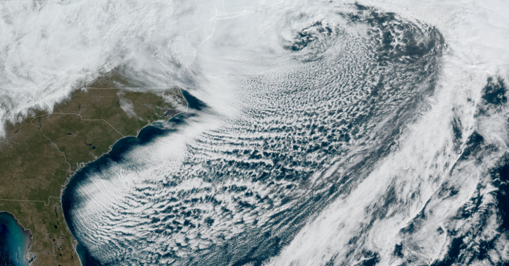
Satellite images on Monday morning revealed the textbook “comma cloud” shape of a powerful nor’easter. The storm’s long tail stretches south through the Florida peninsula, while the main “head” of the comma churns over the Northeastern United States, where the most severe conditions have been unfolding.
Anatomy of the “Bomb”
The tight, pinwheel-like circle at the center of the storm is the hallmark of a “bomb cyclone.” While the term sounds alarming, it is a technical description of a storm undergoing bombogenesis — an explosive drop in barometric pressure that tells meteorologists a storm has intensified rapidly.
Typically, a storm “bombs out” if it drops 24 millibars of pressure in 24 hours. As of 7 a.m. Monday, this system had far exceeded that benchmark, dropping 41 millibars in 24 hours.
Where the Worst Hits
The heaviest snowfall and most damaging winds are concentrated in the head of that comma, just west and northwest of the storm’s center. This is where the counterclockwise flow of the nor’easter scoops up moisture from the Atlantic Ocean and carries it into the subfreezing air sitting over the coast. When it comes back down, it piles up as snow.
Reading the “Cloud Streets”
If you look behind the storm’s tail, you’ll notice a pattern of long, parallel rows of clouds stretching over the ocean. These are cloud streets, or horizontal convective rolls.
They form as frigid air from the continent rushes over the relatively warmer waters of the Atlantic, absorbing heat and moisture. The narrow gap of clear sky you see right along the coastline exists because that cold air needs a little time and distance to pick up enough moisture to condense into clouds. It’s a visual confirmation of the cold air funneling in behind the storm.
Judson Jones is a meteorologist and reporter for The Times who forecasts and covers extreme weather.
The post Get a Close-up View of This ‘Classic’ Nor’easter appeared first on New York Times.