The eight-foot-long underwater robot called Remus 300 dropped into the Atlantic Ocean 16 miles off Cape Hatteras, North Carolina, and descended toward the bottom, where it began to examine the wreck of the famous Civil War vessel USS Monitor.
As the preprogrammed robot reached a depth of about 200 feet, its high-tech sonar scanned the remnants of the old ironclad, which has been resting upside-down since it sank in a gale 163 years ago, drowning 16 sailors.
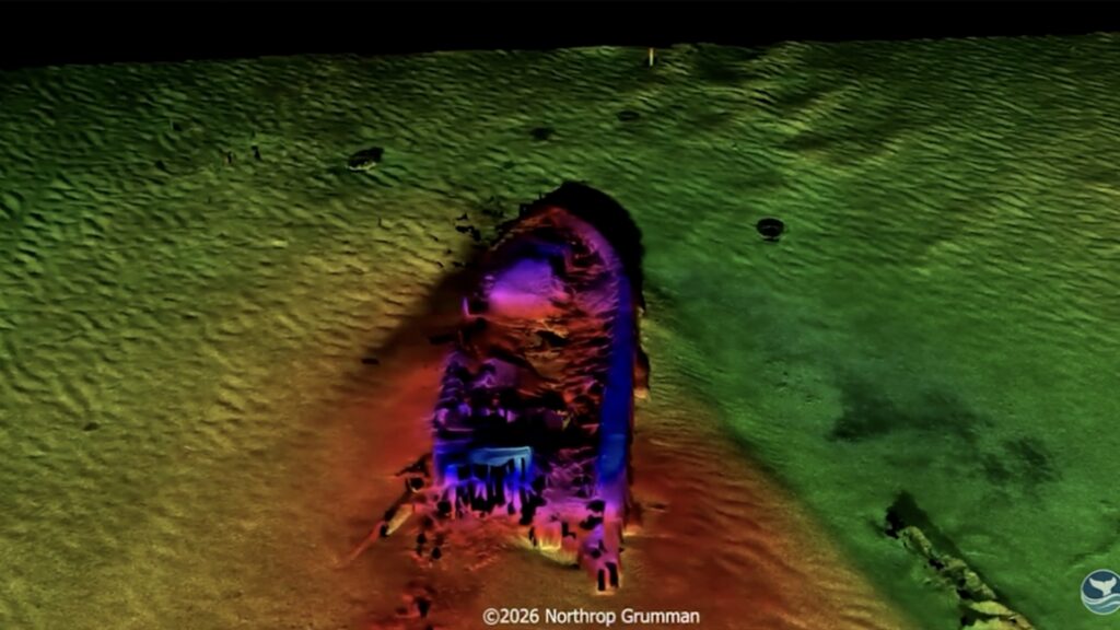
Small sensors aboard the underwater vehicle bounced acoustic waves off the wreck and its surroundings, and recorded the echoes that came back. Gradually, forms took shape.
The results, unveiled Saturday, were the best high-resolution computer images of the wreck ever captured, experts said. During a briefing at the Mariners’ Museum and Park in Newport News, Virginia, scientists detailed their findings and unveiled a color 3D flyover view of the site.
Objects such as the ship’s armor belt, the remnants of the captain’s quarters, anchor well, boilers and keel emerged, as well as a discarded tire from the modern era.
The imagery is “mind-blowing,” Tane Casserley, a maritime archaeologist and Monitor expert with the National Oceanic and Atmospheric Administration (NOAA), said in a phone interview. “I was literally speechless.”
“We’ve seen a lot of pretty amazing technology used at Monitor,” he said. “But these three-dimensional visualizations of the shipwreck [are] unprecedented. … To see the entire wreck site in one go at that resolution is amazing.”
The Monitor is famous for its fight with the Confederate CSS Virginia on March 9, 1862 — 164 years ago. It was history’s first combat between iron-sheathed warships and changed the course of naval warfare.
The scanning expedition, conducted last September, was the work of NOAA’s Monitor National Marine Sanctuary, which oversees the wreck site, and Northrop Grumman’s Technology for Conservation program, which provided logistics, expertise and special synthetic aperture sonar.
In addition to the sonar scans, Northrop Grumman, at Casserley’s request, generated interactive 3D models of the Monitor as it evolved after the battle. “They built me three different virtual models,” he said. “They’re gorgeous.”
The company also created, with the help of Monitor historians, archaeologists and conservators, a new video animation of how the ship sank, he said.
“We believe we’ve now re-created the most accurate version of the Monitor’s sinking,” said Casserley, who is the Monitor sanctuary’s research coordinator. “It really brings home how terrible that night was.”
Forty-seven members of the all-volunteer crew were rescued amid the storm by the USS Rhode Island, which was towing the Monitor.
The Monitor’s battle with the Virginia at Hampton Roads 10 months earlier was a draw, with each ship’s cannonballs bouncing off the other’s iron sides.
Later that year, the Virginia — which had been built out of the former USS Merrimack — was blown up to keep it out of the hands of Union soldiers. Little of it has ever been found.
The Monitor’s wreck site was discovered in 1973. In 2002, the Monitor’s 120-ton turret, its guns and the remains of two sailors were lifted to the surface with the help of the Navy. The turret and guns were taken to the Mariners’ Museum for preservation.
The two sailors, who were never identified, were buried in Arlington National Cemetery in 2013.
Northrop Grumman provided its services for the scanning project free, Casserley said. He said the aerospace company approached him last year, offering its technical capabilities as part of its conservation program.
“We have this great technology,” said Dennis Grignon, an undersea missions and strategy expert at Northrop Grumman’s Naval and Oceanic Systems site in Annapolis. “We also know that there’s a gap with some of the conservation efforts where they need to be able to see in unseeable places on the seabed.”
In September, the experts took their equipment to sea aboard the company’s research vessel, Discovery. The sensors were installed aboard the torpedo-shaped underwater vehicle beforehand.
“You actually transmit an acoustic wave,” Justin Zepp, manager of the micro sonar program at the Annapolis site, said in a phone interview. “It bounces off the bottom, and you receive it back. And from that echo, if you will, you can discern and actually create images that look like camera images.”
The underwater vehicle was programmed to go to the wreck site and stay about 50 feet off the bottom, Zepp said. It then scanned the wreck area, sweeping back and forth in a lawn-mowing pattern. Finally, it circled the wreckage to zero in on the Monitor for even more detailed views.
“This is a shipwreck that basically no one can visit because it’s so difficult to get there,” said Casserley, of the Monitor sanctuary.
“You can dive it,” he said. “But the weather and the currents and Cape Hatteras being a treacherous place — barely anybody can see the thing. So it’s our job to bring that story to the people.”
The post New sonar images are best ever captured of famous Civil War vessel wreck appeared first on Washington Post.