Don’t put your snowblowers away just yet.
After much of the Midwest basked in sunshine and above-average temperatures this past week, a snowstorm that could rank among the strongest ever in the region is set to barrel through in the coming days.
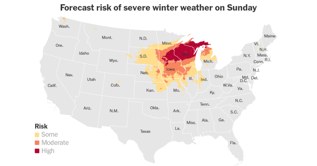
The system is expected to leave a foot to over two feet of snow in a corridor that stretches from Minneapolis and St. Paul in Minnesota through Northeast Wisconsin and into the Upper Peninsula of Michigan and Canada.
“This looks like it could definitely be a top 25 storm of all time,” said Brent Hewitt, a meteorologist at the National Weather Service in the Twin Cities. “That’s going back 140 years for our climatological data.”
While Minnesotans are accustomed to the volatility of March weather, the mood a little farther south is less stoic. Zachary Yack, a meteorologist at the National Weather Service in Chicago, noted that social media reactions to the upcoming winter weather have been a “mixed bag,” with many residents less than thrilled about winter’s sudden return.
The region will see the first signs of the system early in the weekend, but the primary concern is a dynamic storm developing Saturday that will bring a wide variety of hazards through Monday, including the potential for tornadoes on the storm’s southern edge and blizzard conditions on its north.
What to Watch For
-
Abundant snow: Major accumulations are expected Sunday into Monday for Minneapolis and St. Paul in Minnesota and for Green Bay, Wis.
-
Severe weather: Strong to severe thunderstorms are possible Sunday afternoon, primarily from southern Michigan down to northeastern Texas. These storms carry a threat of damaging winds and tornadoes.
-
Blizzard conditions: As the storm exits Sunday night into Monday, gusty winds reaching 45 to 50 miles per hour could lead to blowing snow and near-whiteout conditions.
-
Flooding: The eastern side of this storm will move through the Northeast on Monday and could bring a flooding risk in areas with snow- or ice-covered water, which could exacerbate flooding.
In Northeast Wisconsin, the forecast was particularly striking. “Potentially, there could be a couple spots that could get close to two feet of snow, and for us here in Northeast Wisconsin, that’s a pretty rare event,” said Roy Eckberg, a forecaster in Green Bay.
In the Twin Cities, the stakes are equally high. To crack the top 25 historical list, the storm would need to produce at least 13 inches of snow. To reach the top five, it would need to surpass 17.1 inches — the mark set by the infamous 2010 “dome buster” storm that deflated the roof of the Metrodome.
“We’re looking at 10 to 15 inches here in the Twin Cities, with the potential we could see some amounts encroaching 20,” Mr. Hewitt said.
Historically, the heaviest snows in the Upper Midwest often arrive at this time of year. Mr. Eckberg noted that some of Green Bay’s most significant snows occurred in the spring, including an April 2018 storm that dropped nearly two feet. This upcoming system will most likely transition from a heavy, wet snow on Sunday to a drier, powdery snow by Monday as cold air punches in behind the front.
Chicago residents will experience the most dramatic roller coaster. Sunday afternoon will bring the threat of severe thunderstorms and damaging winds. Once the front passes Sunday night, rain will transition to snow, with a likely chance of two to four inches. Even with lower totals, 45-m.p.h. winds will most likely cause significant drifting on Monday.
The intensity of this snow is being described as more characteristic of the East Coast. Mr. Hewitt noted that the expected snowfall rates of two inches per hour are more typical of a nor’easter. “That’s not something we’re accustomed to up here,” he said, pointing out that the Midwest lacks a nearby ocean to fuel such prolific rates. Instead, this storm is tapping into a rare “atmospheric river” connection from the Pacific, supplemented by moisture from the Gulf of Mexico.
There is still a “fail mode” for the forecast: If warmer air noses farther north than expected, snow could transition to sleet, which is far less efficient for accumulation. However, for most of the region, the higher snow outcome remains very likely.
As Mr. Yack put it: “No matter where you are, if you’ve been in a warmer stretch and you go back to a colder period, it definitely is a little bit of a shock to the system.”
Judson Jones is a meteorologist and reporter for The Times who forecasts and covers extreme weather.
The post Late-Winter Storm Set to Slam Upper Midwest This Weekend appeared first on New York Times.