Weather forecasters were warning residents across a large section of the Central United States on Friday that one of the first big storm systems of the spring season could deliver anything from damaging winds and large hail to tornadoes and heavy downpours.
About 50 million people from Texas to the Great Lakes faced the potential for some severe weather as storms move through on Friday.
Forecasters had warned this week that the country faced over a week straight of some level of potentially hazardous weather starting Wednesday, and that Friday was expected to be among the most severe. Late Wednesday, storms moving through the Dallas-Fort Worth area flooded highways and broke daily records for rainfall, local media reported. There were reports of large hail across north central Texas, Arkansas and southern Missouri.
“It’s starting to get to that time of year when we see more days of potentially severe weather,” said Erin Maxwell, a meteorologist with the National Weather Service’s office in Norman, Okla.
Friday’s storms are expected to last from the afternoon into the evening, and could continue overnight, forecasters said. The main threats on Friday include large hail (some possibly larger than a baseball), damaging wind gusts reaching over 80 miles per hour and strong tornadoes, especially across eastern Oklahoma, eastern Kansas and western Missouri.
“These early-season events can catch people off guard, coming off winter and more tranquil conditions,” said Steve Cobb, a forecaster with the Weather Service office in Tulsa, Okla. “That brings concern.”
Closer to the Great Lakes, severe wind gusts are likely to be the primary threat, as well as a possibility of tornadoes. Repeated thunderstorms will also bring the risk of flash flooding, especially across northeastern Texas, eastern Oklahoma and parts of Arkansas, Kansas and Missouri.
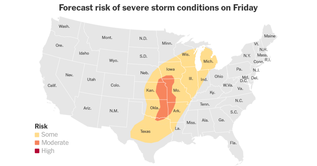
Kansas City and Springfield in Missouri and Tulsa, Okla., are all in the bull’s-eye of an area the Weather Service said was at the highest risk for potentially dangerous weather on Friday.
Mr. Cobb said that for eastern Oklahoma, he was most concerned that supercell thunderstorms could develop between about 3 p.m. and 7 p.m., ahead of a cold front that will move through the region that night.
This type of isolated thunderstorm has updrafts that rotate and “produce the most violent weather in terms of hail and tornadoes,” he said.
There’s also a threat of supercell thunderstorms in the greater Kansas City area from about 4 p.m. to 7 p.m., but the risk there is most likely lower than it is in Oklahoma.
Outside the areas at highest risk, a broad region facing a slightly reduced risk includes Dallas and Austin in Texas, as well as Chicago, Milwaukee, Omaha and St. Louis.
Here’s what else to know:
-
Severe storms are also expected on Saturday. The areas at highest risk are expected to be from the Texas Gulf Coast into western Louisiana, and toward the Great Lakes. Damaging winds will be the primary threat, except in parts of Texas, where large hail could also occur.
-
The risk for flash floods continues across portions of Texas, Oklahoma, Arkansas and Louisiana, through the middle of next week. For places that don’t flood, this will be much welcomed rainfall.
-
Into early next week, forecasters said that Tuesday was likely to be another especially unsettled day.
Nazaneen Ghaffar is a Times reporter on the Weather team.
The post What to Expect From Severe Storms Rumbling Through the Central U.S. on Friday appeared first on New York Times.