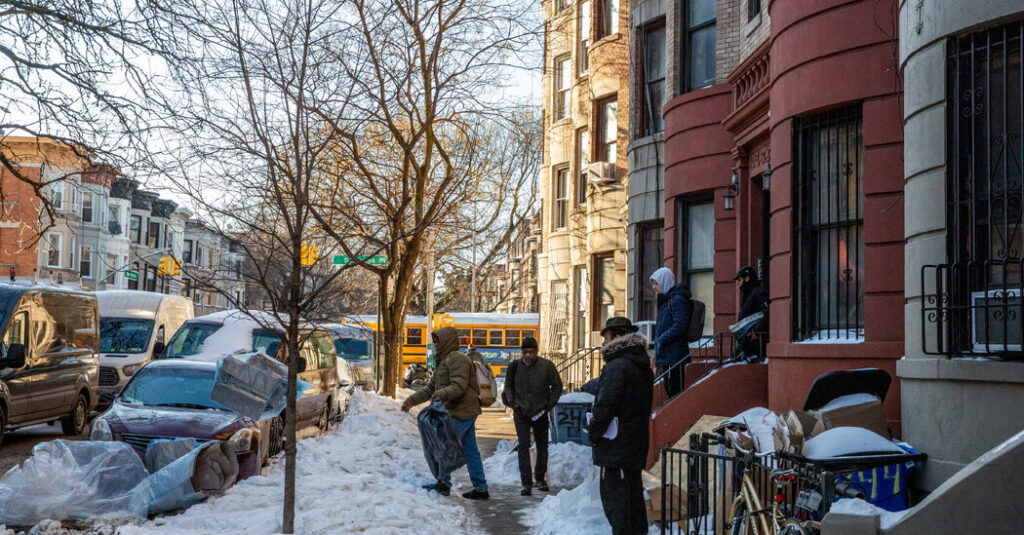
Last month’s snow remains stubbornly frozen in gutter-side heaps across New York City, and with temperatures set to plunge again, it’s likely to remain there for a while.
A fresh dusting of snow this weekend could coat the grime-encrusted piles, but the real story is the biting cold trailing behind it, with forecasters warning that it will be sharp and noticeable.
“Friday we’re looking at highs around 30, and then we’re down to the low 20s on Saturday,” said Bryan Ramsey, a meteorologist at the New York office of the National Weather Service. “Combine that with the strong winds we’re going to get, that’s going to leave us with very low wind chill values, into the single digits.”
A fast-moving storm system is expected to move through parts of the northern United States on Friday. Bob Oravec, a meteorologist at the Weather Prediction Center, said heavy snow was expected in some places, particularly across areas downwind of the Great Lakes. There could be up to six inches or more starting Friday night, including in major cities such as Cleveland, Buffalo, Rochester and Syracuse. In its wake, temperatures will plummet once again.
New York, where temperatures have barely nudged above freezing for weeks, could receive up to two inches. Some of the city’s parks remain blanketed in white. On the streets, the scene is less pristine: Taxis dodge mucky mounds while pedestrians move single-file through narrow valleys cut into gray-brown slush. A forecast of one to two inches of new snow may not be what most New Yorkers want, but it will at least provide a clean veneer over the dirty, ice-covered remnants of the last storm.
“A lot of it is going to happen on Friday night when people are in bed sleeping,” Mr. Ramsey said. “So they’re going to wake up to just a new coating, up to around two inches of snowfall, and then they’re really going to notice the cold weather.”
The culprit is an Alberta clipper — a fast-moving winter storm system originating in Western Canada that “clips” through the Midwest and Northeast. While these systems are known for light snow and high winds, this particular clipper is ushering in an Arctic air mass that may rattle residents who hoped the season’s deepest chill had passed.
“Temperatures are going to be falling during the day on Saturday,” Mr. Oravec said. “In Washington, D.C., for example, temperatures will be 30 degrees at midnight, then it just falls to 20 by sunrise, and then by noon to 15.”
The primary concern, however, is the wind chill — the perceived temperature on the skin as wind strips away the body’s protective layer of heat.
Mr. Oravec said the lowest wind chill values were expected on Saturday.
“It’s not going to be as bad on Sunday because the winds won’t be quite as strong,” he said. “But the temperatures are still going to be in the teens, so it’s still going to feel real cold.”
Extreme cold watches were in place for Friday through Sunday over swaths of the Northeast, including much of New York State and areas of Pennsylvania and New England.
The Weekend Outlook
-
New England: Wind chills are likely to drop to -30°F or lower in some areas. Gusts exceeding 50 miles per hour could lead to downed trees and power outages.
-
New York City: The peak intensity arrives Saturday night into Sunday morning. Wind chills in the five boroughs could bottom out between -15°F and -20°F.
-
Record potential: Highs and lows across the region will sit 15 to 25 degrees below early February standards, threatening several longstanding daily records.
The reprieve will be relatively swift. Temperatures are expected to moderate early next week, returning to near-normal levels by Wednesday. However, as any local knows, the season is far from over; more winter weather may already be lurking for the next weekend.
“There’s definitely a signal in the weather models for a storm to develop across the southern plains on Friday and push northeastward toward the Northeast on Saturday,” Mr. Oravec said. “So probably a good chance of some type of precipitation, but details on whether it changes to snow, sleet or freezing rain are not yet clear.”
Judson Jones is a meteorologist and reporter for The Times who forecasts and covers extreme weather.
The post Bad News for New Yorkers Weary of Winter: More Snow and More Cold Are Likely appeared first on New York Times.