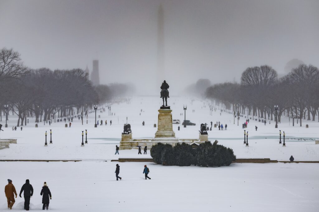
The winter storm that shut the D.C. area down Sunday was an exceptional one — not simply because of how much precipitation fell, but because of what fell and how cold it was when it fell.
The defining feature of this storm was historic sleet, falling at uncommonly low temperatures. That combination — heavy sleet embedded in deep cold — created a storm that will prove far more disruptive and longer-lasting than a typical snowstorm.
Usually, when sleet falls, it does so in small quantities, often less than an inch, and at temperatures near freezing. But this storm spilled up to 4 inches of icy pellets, an amount unmatched since at least February 1994, and at temperatures mostly in the teens.
Falling atop 4 to 7 inches of snow, the frozen concoction consolidated to a depth of 6 to 9 inches. But this was no ordinary 6 to 9 inches. The water packed inside was comparable to the contents of a 20-inch blizzard. And with nighttime temperatures forecast to plunge into the single digits for days, the mass will remain frozen solid well into the week. There is no telling when this glacial-like offering will finally melt.
The storm itself was born from a remarkable confluence of extremes. As an unusually intense Arctic air mass, sourced from Siberia, surged southeastward, it collided with a jet of moisture streaming in from the Pacific near Hawaii. “To summarize this storm briefly, the Pineapple Express (wet) meets the Siberian Express (cold),” the National Weather Service wrote ahead of the storm.
That unusual setup made this a bear of a forecast. The competing air streams and narrow margins between snow, sleet and freezing rain flummoxed forecasters. Poorly tuned weather apps advertised totals over 20 inches, and in the meteorological community, three forecasters could easily offer 30 opinions.
Against that backdrop, we are proud of how this forecast performed at the Capital Weather Gang. Although we made some mistakes in how we predicted and communicated aspects of this storm, we captured the essence of what it would deliver more than 48 hours in advance — and we did not waver.
How much precipitation fell
This ranks as one of the largest snow events of the past decade, including the sleet that fell (sleet officially counts as snow in official recordkeeping). D.C., based on observations at Reagan National Airport, recorded 6.9 inches, which is the third most since the historic “Snowzilla” storm in January 2016 that unloaded 17.8 inches.
Two bigger snows occurred since. Last January, a storm dropped 7.2 inches, and 10.3 inches fell from another in January 2019.
Amounts across the region ranged from 6 to 12 inches north of the Beltway, to 6 to 9 inches in the Beltway area and generally 4 to 8 inches to the south.
The inches of wintry accumulation tell only part of the story. The 6.9 inches of frozen mix in D.C. would melt down to the equivalent of 1.99 inches of rain, a record for Jan. 25. Once the snow melts, this amount of water will put a dent in the severe drought affecting the area.
The amount of precipitation from this storm was comparable or even in excess of some of the recent great storms like Snowzilla, “Snowmageddon” in February 2010 and “Snowpocalypse” in December 2009.
The 2 to 4 inches of sleet was particularly unusual. The most recent storm to produce substantial sleet occurred in February 2007. While it produced more freezing rain, it was not as big as this storm. The amount of sleet that fell Sunday was the equivalent of 7 to 14 inches of snow by itself.
D.C. now has 8.5 inches of snow on the winter, about 2 inches above the norm to date. Average January snowfall is 4.9 inches, or 36 percent of the 13.7-inch winter average. D.C. has now had above-normal snow in January in three straight years.
How the storm came together
The epic snow and sleet storm that pummeled our region resulted from two factors. The first, the Siberian Express, is a massive dome of deeply frozen arctic air surging down from Canada, propelled south by high pressure (blue H’s across northern tier of U.S. in the image below).
The second element is the arrival of a stream of energy (the subtropical jet stream) and plume of deep moisture originating from the southwestern U.S., and eastern Pacific, called the Pineapple Express. Also drawing moisture from the Gulf of Mexico, the moist current overrode the dense, cold air mass advancing from the north into the middle and southern U.S.
Storminess, in the form of multiple low-pressure cells, erupted in a chain along the southern tier of the United States (red L’s in the graphic below).
These storms helped to concentrate and lift the moisture into a continuous band of frozen precipitation, heavy snow (blue shades) to the north, and intense sleet/freezing rain (orange tones) to the south.
Winter storm warnings were issued along a massive arc from western Texas to New England (pink region in image below). It’s estimated that these warnings, taken together, directly affected 147 million Americans. The purple clusters of warnings along the southern tier are for ice storms, where a glaze of ice exceeded a quarter of an inch. In fact, those icy coatings grew into the half- to 1 inch range in many locations, crippling entire communities and knocking out power to nearly a million customers. Louisiana, Mississippi and Tennessee were particularly hard hit by outages.
The forecast models gave consistent clues in the five-to-six-day period before the event, that an extraordinary combination of snow, sleet and/or freezing rain would fall. The difficulty was discerning the relative fraction of snow versus sleet versus freezing rain.
All the way up to the day of the storm itself, models conflicted on the amount of freezing rain versus sleet. In the immediate D.C. region, the sleet won out, sparing our power grid but encrusting the snow with 2 to 4 inches of the dense, crunchy ice. The storm gave forecasters a new respect for the limitations still inherent in even our most sophisticated and trusted forecast models. These are valuable lessons learned should this ugly combination of Siberian and Pineapple elements rear their head again.
How the forecast performed
We began discussing this event a week in advance when we posted a message on social media about “a decently strong signal” for a winter storm. Our first full briefing on the storm, published Tuesday, warned that a “major” winter storm could strike and discussed several scenarios for how it could play out, or even miss. At the time, some computer models were simulating 20 inches or more of snow.
On Wednesday, we headlined the potential for “one of D.C.’s biggest” winter storms in years. “The snow and perhaps ice, accompanied by bitter and long-lasting cold, could cause major disruptions to schools, airports and businesses Sunday into next week,” we wrote. It was on that day that we perhaps overplayed the snow potential and didn’t adequately convey the possibility of ice (few models suggested substantial icing at this time). We stated there was a chance the storm could produce double-digit snow amounts, the most since Snowzilla.
By Thursday, it was apparent this storm would probably produce more of a mix but still would be extremely disruptive, and we accurately communicated that. “A massive and powerful winter storm remains on track to wallop the D.C. region this weekend, unloading disruptive amounts of snow and ice,” we wrote. That day, we released our accumulation forecast map, which predicted 5 to 10 inches of snow through the heart of the region. It was largely accurate, although it did not include the potential for sleet.
The next day, we recognized that there would be less snow but that the amount of sleet would compensate, and our final snowfall map projected a combination of 5 to 9 inches of snow and sleet in the heart of the region, which was on the money.
We did somewhat overpredict the amount of freezing rain that would fall, because of the difficulties discerning the possible transition from sleet discussed in the previous section. As such, we overplayed the risk of power outages. But we trust that readers are okay with that part of the forecast not coming to pass.
The post Why the winter storm in D.C. on Sunday was so exceptional appeared first on Washington Post.