“This storm will be talked about for a very long time,” Caitlin Dirks, a meteorologist with the National Weather Service said on Friday as she and her colleagues in Memphis monitored a forecast that placed her city at the hypothetical dividing line between disruptive snow and what she described as “historic” amounts of ice.
“We are calling this winter storm historic because the just sheer ice totals that we’re forecasting are — they will be crippling for infrastructure,” Ms. Dirks said.
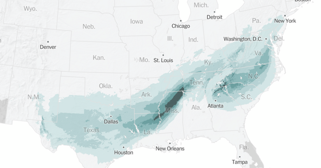
There are two main areas of concern for ice from this storm. One is from Texas to Tennessee, with a bull’s-eye of intense freezing rain over Mississippi. The other is up against the Appalachians, which would cause widespread ice in the Carolinas down to northern Georgia.
While a foot of snow can be a major concern in some regions, even a quarter of an inch of ice can be far more dangerous.
“When ice starts to accumulate to a quarter of an inch or above, then we start talking potential power outages and tree limbs falling,” said Damien Hill, a meteorologist with the National Weather Service office in Shreveport, La.
When ice accretion — the amount of freezing rain that attaches to physical objects — begins measuring near one inch, it will almost certainly cause widespread power outages that could last for days, according to Rodney Hinson, a meteorologist at the Weather Service office in Greenville, S.C.
That level of accumulation is also enough to take down trees, Ms. Dirks said.
“Freezing rain is the most dangerous precipitation type just because of how well it sticks to things and how well it accumulates on top of itself,” she added. “It adds thousands of pounds of weight to anything that it accumulates on.”
Memphis is in a particularly precarious location. If the storm shifts even slightly north or south, the city — a Mississippi River hub where two major interstates meet at critical bridges — could face pure ice, heavy snow or, more likely, a dangerous combination of both.
Ms. Dirks warned that residents in the transition zone between freezing rain and snow might see lower totals for both, as much of the precipitation will likely fall as sleet.
Sleet pellets often condense into a thick slush, forming a layer of ice on road surfaces that can remain for several days, she said.
The forecast hinges on a layer of cold air near the surface. In the South, winter precipitation often fails to accumulate because the ground is too warm. This time, however, it is cold, and forecasters are concerned.
“It kind of looks like with this event we may be in the mid- to upper 20s,” Mr. Hill said. “And so I think that that’s going to be cold enough for ice to become a problem even on the roadways.”
Judson Jones is a meteorologist and reporter for The Times who forecasts and covers extreme weather.
The post Why the Ice Forecast Has Officials Worried Across the South appeared first on New York Times.