A significant winter storm could affect the D.C. area this weekend, with substantial amounts of snow and record cold weather if key ingredients come together. The storm, forecast to develop Friday in the Southern United States, could produce hazardous winter weather over a vast area, stretching from Texas to southern New England.
Snow could begin in the D.C. area late Saturday or early Sunday and continue until Monday morning — meaning a potentially long duration event that affects schools and businesses next week. However, there’s a possibility that the cold air pushes the storm so far south that it largely misses the D.C. area. There’s also an outside chance that, depending on the track of the storm, snow could mix with or change to sleet or freezing rain for a time.
“Confidence in accumulating snow this weekend continues to increase, but there is still a wide range of possible outcomes when it comes to exact amounts and severity of impacts,” the National Weather Service office serving the D.C. area wrote Tuesday.
Model simulations for snowfall in the D.C. area average range from 0 to 15-plus inches. With the storm still 5 or 6 days away, it is too early to project specific amounts.
A blast of Arctic air entering the northern U.S. on Wednesday and Thursday will set the stage for the storm. As it plunges southeastward toward the East Coast, it could establish cold temperature records on Friday and Saturday from the Great Lakes to the Mid-Atlantic. In D.C., highs could struggle to reach 20 Saturday.
The storm is forecast to take shape as a weather disturbance originating from California combined with another disturbance diving south from Canada. This will probably occur over the South near the intersection of the frigid Arctic air and warmer air wafting north from the Gulf of Mexico. But there remain questions with respect to the location and timing of this merger that could affect the forecast.
As the storm forms, it will probably spread a swath of snow from the southern Plains to the Ohio Valley and Mid-Atlantic, with freezing rain occurring unusually far south across the Gulf Coast states into the Southeast.
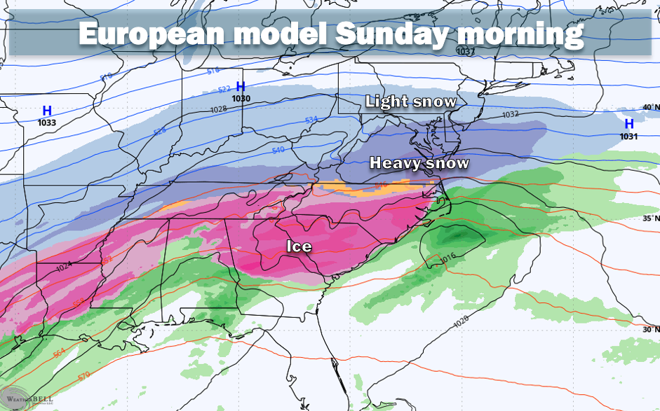
How much snow do the models predict?
Of dozens of simulations from multiple modeling systems, the average snowfall forecast is around 8 to 10 inches, but that amount is by no means a lock as there is a large range of projections.
Here is how much different models are projecting for the Beltway area:
- UKMet: 15-plus inches
- Canadian and German models: 10 to 11 inches
- European model: 9 to 10 inches
- European AI model: 8 inches
- American AI model: 2 inches (primary simulation) | 5 to 6 inches (system average)
- American model: 1-inch (primary simulation) | 7 to 8 inches (system average)
The American model is an outlier with its relatively low snowfall forecasts. It hasn’t performed well this winter, but its idea that precipitation may be somewhat limited is not completely unreasonable considering how low temperatures are forecast to be. It would be unusual (though not unprecedented) for D.C. to get a big snowstorm with temperatures in the teens. When it’s that cold, often the heaviest precipitation remains to the south.
However, with temperatures forecast to be so low, any snow that falls will be quite powdery, meaning it will pile up fast. So, it may not take a ton of precipitation for significant snow accumulation.
What could limit the amount of snow we could get?
The storm could be a bust if it tracks too far south. That would happen if the California disturbance moves east more slowly and fails to strongly interact with the system diving south from Canada. Without enough interaction between those two features, it becomes much harder to pull moisture from the Gulf of Mexico north into our area. Some models are showing this lower-impact scenario.
How could this become a really big snowstorm?
This storm could produce double digit totals in the D.C. area if the two disturbances effectively merge and draw moist air from the south over the area for an extended duration, while the storm tracks to just east of North Carolina. Similar setups in the past have produced amounts of 8 to 14 inches in the area. The UKMet and Canadian models show this scenario.
Because the storm — at least right now — is not predicted to rapidly intensify off the Carolina coast and move slowly northward, historic amounts of snow aren’t likely.
How cold will it be?
After highs flirt with 50 on Thursday, cold air will begin to trickle into the area on Friday, with highs in the 30s but lows dipping into the teens Friday night (even single digits possible in colder areas north and west of the Beltway).
Forecast highs over the weekend are only in the teens to low 20s. If they hover in the teens, they would challenge calendar-day records.
Whatever snow falls will stick around for a long time. Predicted highs next weeks are mostly in the 20s and lows at night would probably frequently fall into the teens and single digits (in colder areas away from D.C.). Winds chill near or even below zero would be possible at times.
How to prepare
With the storm 5 to 6 days away, there is plenty of time for the forecast to change, and it’s premature to change plans such as scheduled flights or appointments. But you might begin to think about having a Plan B if a major storm materializes Sunday and Monday.
Now is not a bad time to shop for snow clearing supplies like shovels and salt before a possible big rush.
By Thursday or Friday, we will have higher confidence in the forecast and that will be the time to begin consider shifting plans if significant snow and ice are still predicted.
We will post detailed briefings on the storm each day — assuming it remains a threat — and will also post updates on social media (on X, Blueskyand Facebook).
The post A major winter storm could affect the D.C. area this weekend: What to know appeared first on Washington Post.