Traveling during the holidays can often be a bit of a gamble, and this year, a series of storm systems sweeping across the country are threatening to upend plans for many people.
Here’s a look at the systems to watch, and when they’re expected to hit.
The Immediate Hurdles: Avoid Friday Travel
If you have the flexibility to move your departure up or back, think twice about traveling on Friday, especially in the Northeast.
A powerful system brought blizzard conditions to the Plains on Thursday, and now it’s shifting east. It’s expected to arrive in the Northeast with a significant push of wind that could easily set off flight delays across the region and into eastern Canada. It may even send untethered holiday decorations and lawn ornaments flying, according to Jim Connolly, a meteorologist with the National Weather Service in New York.
This system will be deceptively warm and windy in the morning ahead of the rain, before turning blustery and cold by Friday afternoon.
As the storm intensifies, it will advance to the northeast up into Atlantic Canada by Friday evening, Mr. Connolly said. Most of the fresh snow will be limited to the Great Lakes, eastern Canada and the parts of New England that are farther inland from the Atlantic coast.
A Very Stormy Few Days for the West
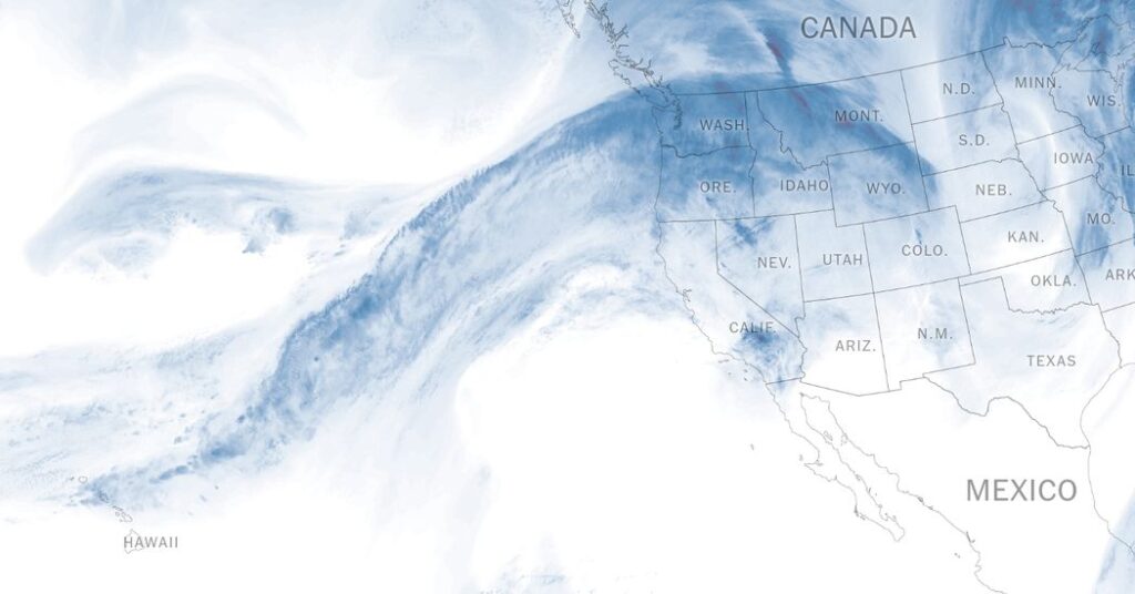
Out west, the story is water. An extremely wet atmospheric river began soaking Oregon on Thursday and is expected to continue into Friday, bringing a threat of major flooding — which could be record-breaking in some places.
Scott Kleebauer of the Weather Prediction Center said forecasters are predicting “some pretty hefty” precipitation totals, especially around the coast of Oregan and the southern Cascades.
But a huge swath of the West Coast, from British Columbia down to Southern California, is entering an active weather week.
-
The Travel Window: If you are navigating the West Coast, Tuesday looks like the cleanest “sneak-out” day between major systems. Still, check your local forecast, as the storms are changing quickly.
-
The Shift to Snow: While the Pacific Northwest deals with rain in the immediate future, next week the systems are looking colder. This is good news for people across the Pacific Northwest and southwestern Canada, as it shifts the threat from rising rivers to mountain snow.
-
The “Dry Pattern” Ends: It’s been dry in much of California lately, but that’s about to change. Tony Fuentes, a meteorologist with the National Weather Service in Reno, Nev., noted that the region is shifting out of its recent dry pattern just in time for the holidays. (The incoming storms are also responsible for helping to finally bring an end to a weekslong fog that has lingered in the Central Valley since before Thanksgiving.)
What to Expect for Christmas
While forecasts a week out are prone to significant changes, computer models have been remarkably consistent in predicting the potential for a major storm for Christmas Eve and Christmas Day in the West.
This system has the potential to be a “prolific” snow event across the Northern Central Sierra, Mr. Kleebauer said. In the Tahoe Basin, the air may be cold enough to bring those flakes all the way down to lake level, Mr. Fuentes said, potentially turning the region into the quintessential winter postcard. And when that same system moves toward Southern California, it could give the region a very wet holiday.
For the rest of the country, the dream of a white Christmas looks increasingly like a green Christmas reality. A few quick-hitting winter storms may push through the Northeast, dropping snow that could stay on the ground through Christmas, but fresh snow for the holiday is unlikely.
And for many people, it’s looking to be a warm Christmas, too: From Christmas Eve through Christmas Day, the central United States could see widespread high temperatures 20 to 30 degrees above normal.
Amy Graff contributed reporting.
Judson Jones is a meteorologist and reporter for The Times who forecasts and covers extreme weather.
The post Winter Weather Kicks Into High Gear Just in Time for Christmas Travel appeared first on New York Times.