A quick burst of snow is possible early Sunday as yet another blast of Arctic air charges into the D.C. region. However, the potential for accumulation may be limited because of the storm system’s short duration and above-freezing temperatures ahead of its arrival.
The Sunday system now has most of our attention as the chance of snow on Friday that we previously discussed has all but evaporated. It could bring a dusting to an inch in central Virginia, but will probably pass too far south for more than flurries in the D.C. area.
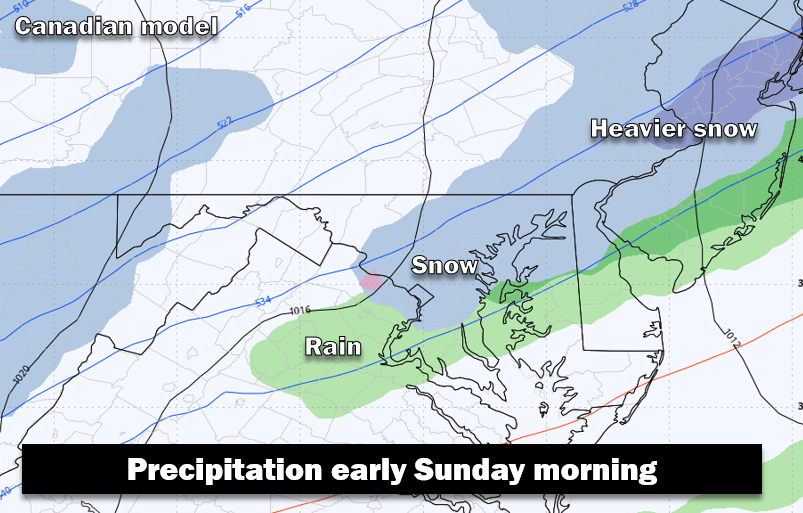
Sunday’s system, diving southeast from the Great Lakes into the Mid-Atlantic and Northeast, will spread more precipitation over a larger area since it will be more energetic and may tap into some Atlantic moisture.
In the D.C. area, snow or a mix of rain and snow could develop during the predawn hours and taper off a little after sunrise (the window for precipitation is roughly 1 to 8 a.m.). There’s a possibility of a short period of moderate to heavy snow, especially northeast of D.C.
While subject to change, we see the most-likely scenario being a coating to an inch around the D.C. area but 1 to 3 inches from Annapolis and Baltimore to the northeast. There could be some slick spots Sunday morning but we don’t see this as a high-impact snow event. That said, the cold air that follows the snow will be bitterly cold. So what falls will stick around and will freeze solid by late afternoon or evening, when temperatures will be plummeting through the 20s.
The accumulation forecast is tricky for two main reasons:
- Temperatures will probably be above freezing when the precipitation arrives. This weather system will herald the coldest weather of the season but, before it arrives, temperatures will probably be in the mid- to upper 30s. This means that the precipitation could start as rain before changing to snow and that the snow will not immediately stick. Once the snow gets going, it should cool the air and ground enough to allow for some accumulation. But, because of the snow’s short duration, the window for accumulation may only be a couple of hours.
- The heaviest precipitation may focus northeast of D.C. The most energetic part of this weather system and the zone of heaviest precipitation may focus concentrate in the zone between Baltimore and southern New Jersey. Models differ on exactly where the heaviest precipitation will occur but the overall setup supports more snow to the northeast. There’s an outside chance it extends into the D.C. area and its eastern suburbs; in that scenario, up to a few inches of snow could occur.
Here’s how much different models project for the Beltway area:
- German: 2 to 3 inches
- American: 1 to 3 inches
- American AI, European: 1 to 2 inches
- European AI and NAM: Dusting to 1 inch
- UKMet and Canadian: Rain-snow mix, little or no accumulation
(These model forecasts assume all snow will stick, so are probably overdone somewhat because of the temperatures when precipitation begins.)
It’s important to note that most models exhibit a sharp cutoff in accumulating snow to the south and west of D.C. Much less snow is generally predicted to the west of Fairfax and Montgomery counties and south of Prince William County. The forecast is particularly uncertain because the D.C. area is along the edge of accumulating snowfall. And when you consider above-freezing temperatures may cut into accumulation, confidence in potential amounts is even lower.
Taking everything together, here are Capital Weather Gang’s projected odds for different snow amounts in the Beltway area:
- No accumulation: 30 percent
- A dusting or coating: 30 percent
- 1 to 2 inches: 25 percent
- 2 inches or more: 15 percent
We will continue to refine this forecast and will have greater confidence by Friday and, especially, Saturday.
Wes Junker contributed to this report.
The post Some snow could fall Sunday in D.C. area while Friday’s chance fades appeared first on Washington Post.