The apostle Paul traveled widely across the Roman Empire to spread the Christian faith. One key segment of his second missionary journey, which began in A.D. 49 in Jerusalem, involved an extensive overland trek across modern-day Turkey to Alexandria Troas, a city south of ancient Troy.
This route, if completed entirely by land, covered about 1,250 miles and would have taken some 524 hours to walk, or a slightly shorter 466 hours if traveling by donkey.
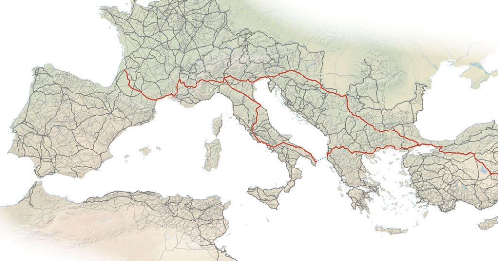
We know this because a study published last month in the Nature journal Scientific Data significantly updated the estimated size of the Roman Empire’s road system, increasing its total length to 187,460 miles from about 120,000 miles. Rome probably achieved peak road sometime around A.D. 150, when the empire was at its most prosperous and extensive. But the database tallies all the roads presumed to have existed during Rome’s life span, from roughly 312 B.C. to A.D. 400.
“The data set does not reflect one particular year or even century because sadly, for the entire empire, we cannot confidently say how the road system changed within the entire Roman period,” Tom Brughmans, an archaeologist at Aarhus University in Denmark who collaborated on the paper, wrote in an email. “We definitely have chronological information for some roads, but this is a minority.”
Previous estimates focused on the main thoroughfares radiating from Rome across Italy and the Empire, including the Via Appia (Appian Way) to the south; the Via Flaminia to the north, and major arteries like the Via Egnatia, across the Balkans, and the Via Domitia, across southern Gaul. The “Barrington Atlas of the Greek and Roman World,” published 25 years ago, served as the most comprehensive resource.
The paper’s revised mileage figure incorporates major highways, strategic routes and local roads often omitted from previous analyses. The accompanying digital atlas, Itiner-e, offers a sophisticated tool for scholars by leveraging historical records alongside satellite and topographic data to model travel times accurately.
Itiner-e reframes how historians view the Empire’s transportation network, Dr. Brughmans said. He proposed that while Roman expansion was clearly aided by an advanced system for moving troops and goods, previous definitions of a “Roman road” have been too narrow, concentrating solely on the grand, engineered thoroughfares.
Dr. Brughmans and his colleagues defined Roman roads more broadly to include any walkable path and used a practical, terrain-following mapping technique, rather than imposing unrealistic straight lines. The change substantially increased mapped networks in North Africa, Greece and the Iberian Peninsula.
Because many Roman roads are now gone or paved over by modern highways, their exact positions were hard to determine; researchers used aerial analysis of the terrain, looking for faint signs in the plant life or subtle changes in height, to find these lost byways.
According to Dr. Brughmans, determining much of the Roman road network is a “game of connecting the dots.” The precise course of most of the roads is unknown, with less than 3 percent of their locations confirmed. The paths are generally inferred from sparse evidence like scattered milestones, leaving the exact route between known places A and B a mystery.
Roads in desert areas are largely hypothetical. Instead of constructing single surfaced roads across the sand, the Romans built a system of parallel tracks to mark wide travel corridors. These routes, which relied heavily on supporting infrastructure like forts and way stations, are represented on the new online atlas by one illustrative line, making the concept of a singular “road” in these areas largely a modern mapping convention, not a literal interpretation.
One of the longest documented Roman trails is detailed in the “Itinerarium Burdigalense,” a travelogue from A.D. 333-334, a time when the Empire struggled with internal issues and external pressures, and the overall integrated network began to suffer as regions became less connected. This journal by an anonymous pilgrim from Bordeaux, France, recorded his 3,150-mile journey to Jerusalem and back, providing a textual map of the route’s stops and distances. (On Itiner-e, the same trip works out to 3,604 miles.)
The legalization of Christianity by the emperor Constantine in A.D. 313 set off a crucial shift in the Holy Land, leading to extensive church and shrine construction. The pilgrimage route, traversing northern Italy, the Danube Valley, the new capital Constantinople, Asia Minor and Syria, allowed travelers to witness these landmark building projects firsthand. Ultimately, this vital road promoted the flow of pilgrims and artifacts, which helped spread Christian traditions throughout the region.
After leaving his hometown, the pilgrim traveled to the East, describing Tarsus, in Cilicia (present-day Turkey), as the Apostle Paul’s city of origin. Along the coastal path (Via Maria) to Caesarea Palaestina, the pilgrim was guided to the spot where Elijah challenged the prophets of Baal and performed a sacrifice. When he got there, the pilgrim spied the bath of Cornelius the centurion and recounted the local tale of a nearby fountain that could induce pregnancy in bathing women.
The road from Bordeaux took the pilgrim to the biblical sites of Sarepta, where a widow provided for Elijah, as recorded in 1 Kings 17:1-16; and Shechem (modern Nablus), at the foot of Mount Gerizim, the burial place of Joseph (Joshua 24:32). Upon reaching Jerusalem, the fourth-century traveler observed what he believed to be both the remarkably preserved blood of the prophet Zechariah (2 Chronicles 24:20-22) and the permanent impressions left by the hobnail boots of those who had stoned him.
Mapping ancient transport paths provides researchers with a 2,000-year-old case study on the centuries-long societal impact of pandemics, Dr. Brughmans said. This strategy aids in comprehending events such as the Antonine Plague of A.D. 165, which is estimated to have killed one-quarter of the Roman Empire’s populace, by connecting its spread to the Roman road system.
Daisy Dunn, a classicist and author of “The Missing Thread: A Women’s History of the Ancient World,” shared her enthusiasm for the project, calling it a “nerdy delight.” She pointed out that despite the Romans’ reputation as master road builders, their ancient routes are often unmarked and easily missed today.
“Architectural enthusiasts are always reminding us to look up and appreciate the edifices towering over us,” Dr. Dunn said. “Perhaps now, digital map in hand, we’ll be tempted to look down again.”
The post All 187,460 Miles of Road That Led to Rome, Mapped appeared first on New York Times.