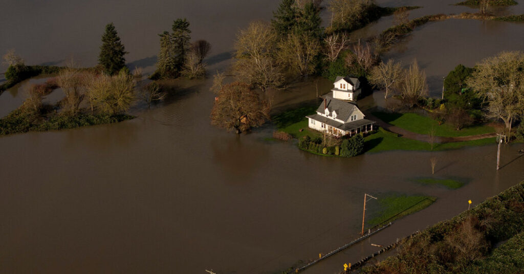
A wet storm system slung across the Pacific Northwest and stretching into western Canada has flooded rivers, closed roads and caused landslides in Oregon and Washington, and forecasters warned that more rain was on the way.
The storm brought an initial round of rain on Monday, which pushed some rivers across the region close to overflowing, and a second, heavier burst was expected Tuesday night into Wednesday.
“What’s coming up is worse,” Cliff Mass, a professor of atmospheric sciences at the University of Washington, said early Tuesday afternoon.
The Snoqualmie River in Washington was approaching major flood stage on Tuesday afternoon in Carnation, a town in the Snoqualmie Valley about 40 miles east of Seattle, according to the Northwest River Forecast Center.
Big, wet storms often cause flooding in Carnation, where Sharon Kerr, a longtime resident, said what she had seen as of Tuesday was “not a big deal.”
“At most, it’s an inconvenience,” she said. Flooding from the river had closed roads nearby in Fall City.
The worst rain is yet to come.
This storm is a two-act event. The initial push of rain arrived Monday and was focused over southern British Columbia in Canada, western Washington and the northern part of western Oregon.
Some of the highest rainfall totals recorded on Monday included eight inches in Paradise on the south slope of Mount Rainier National Park, just over seven inches on Cougar Mountain east of Seattle, and seven inches in Quinault on the Olympic Peninsula.
Downtown Seattle, where the heaviest rain is often blocked by the Olympic Mountains, received much lower totals.
On Tuesday, the moisture shifted south into southern Oregon, giving western Washington and Seattle and northwest Oregon and Portland a break. The rain was expected to return Tuesday night and continue into Wednesday.
The National Weather Service said the rainfall totals for the second push were likely to be higher than it had originally forecast a few days ago as the storm’s path was still coming into focus.
Why this storm is significant
This storm is reeling in an atmospheric river of water vapor off the Pacific Ocean that extends all the way to Hawaii and just east of the Philippines. It’s a common scenario on the West Coast during the winter. These plumes of water vapor are pulled onto land, where they collide with the mountains and are wrung out like sponges, releasing torrents of rain.
This particular storm is notable because it is expected to linger over the region for three days, and the moisture source is especially large, said Chad Hecht, a meteorologist with the Center for Western Weather and Water Extremes at the University of California San Diego.
This all adds up to higher rainfall totals. By Thursday morning, western Washington and the northern half of western Oregon, from the foothills of the Cascade Range to the coast, are expected to record up to two to six inches of rain, with 14 to 16 inches possible in the higher elevations of the mountain ranges.
The higher elevations of Mount Rainier are poised to measure over 20 inches of rain, according to Matthew Cullen, a meteorologist with the Weather Service office in Seattle.
“The Pacific Northwest is a fairly wet place, and even for us, this is significant,” Mr. Cullen said.
Forecasters said the storm could be one of the more significant ones to hit the region in the last five to 10 years.
Regional breakdown
In Washington
An additional two to three inches of rain on top of what has already fallen is expected in low-lying areas of the western half of the state, and five to eight inches over the mountains through Wednesday, the Weather Service said.
This storm will bring a continuing concern for flooding across western Washington and for rivers that flow off the Cascades and Olympic Mountains.
For the majority of the Seattle metro area, the biggest concern continues to be rain collecting on roads and nuisance flooding in areas with poor drainage.
As the ground becomes more and more saturated, landslides will become an increasing concern across western Washington.
On Tuesday morning, a mudslide temporarily closed Interstate 90 in the town of North Bend, 30 miles east of Seattle.
Eastern Washington is expected to receive less rainfall, generally measuring less than two inches in the storm.
In Oregon
The precipitation will be concentrated from Salem to Portland, from the Cascades to the coast.
While Portland could record three to five inches of rain between Monday morning and Thursday morning, Eugene is likely to pick up around one inch.
“Eugene was south of the rain on Monday — they didn’t get rain until today,” said Colby Neuman, a meteorologist with the Weather Service in Portland.
Minor urban flooding is also a concern in Oregon. Five to 10 inches of rain could fall in the coastal mountains and the Cascade Range.
Southern and eastern Oregon are expected to receive less rainfall than the northwest portion of the state, recording less than two inches in most places.
In Canada
Downtown Vancouver is expected to record about one to two inches of rain in this storm, with West Vancouver and North Vancouver likely to measure up to three inches.
Higher totals, up to four inches of rain, are expected in the east Fraser Valley, where a rainfall warning was issued because of the risk of flooding on roads.
Sofia Schwarzwalder contributed reporting.
Amy Graff is a Times reporter covering weather, wildfires and earthquakes.
The post A Deluge of Rain Prompts Warnings in the Pacific Northwest appeared first on New York Times.