A potent storm is set to soak the Pacific Northwest this week, bringing heavy rain that is likely to cause some flooding on rivers and in urban areas.
Western Washington and the northern half of western Oregon, from the foothills of the Cascade Range to the coast, are expected to record up to five to seven inches of rain from Monday through Thursday, with more than 10 inches possible in the higher elevations of the mountain ranges.
Flood watches, which ask people to prepare for potential flooding, were issued across this area.
Minor to moderate flooding is forecast to occur on more than a dozen rivers in Washington and Oregon.
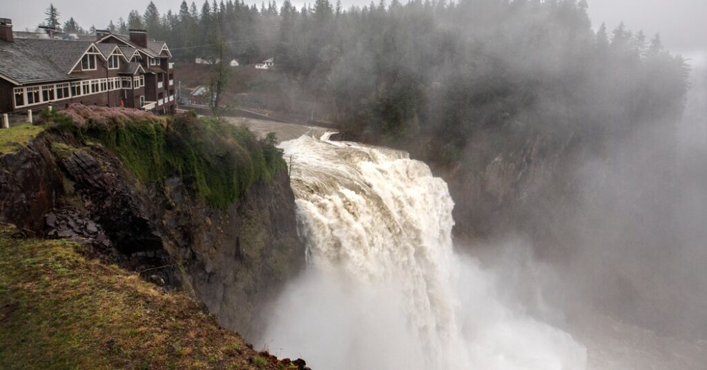
The Snoqualmie River in Washington is predicted to spill its banks, reaching major flood stage in Carnation, a town in the Snoqualmie Valley, about 40 miles east of Seattle, according to the Northwest River Forecast Center.
“The valley is going to flood. It just depends on how bad it’s going to be,” said Cliff Mass, a professor of atmospheric sciences at the University of Washington.
This storm will also bring snow to the highest elevations of the region’s mountains, including the Cascade Range and Olympic Mountains.
Why this storm is concerning
This storm will pull an atmospheric river of moisture off the Pacific Ocean that “extends down to just west of Hawaii,” according to the Weather Prediction Center.
These plumes of water vapor, which travel across oceans and are wringed out by the mountains over land, are common during the rainy season on the West Coast. They provide an outsized portion of annual precipitation to West Coast states.
National Weather Service forecasters in Seattle called the moisture source for this particular storm “very impressive.”
As it interacts with the coastal ranges across southwest Washington and northwest Oregon and the west-facing slopes of the Cascades, the rainfall is expected to be heavy.
What’s more, this storm is slow moving and could sit over Washington and Oregon for several days. When an atmospheric river stalls, it can unload rain for long periods in the same area, increasing the chance of flooding.
“This is not the worst storm that has come through in recent years but it will certainly be a formidable event,” said Rich Bann, a meteorologist with the Weather Prediction Center.
The storm’s timing
The storm is poised to move onshore over the Pacific Northwest early on Monday, with an initial pulse of moisture expected to bring strong winds and continuous rain, particularly over Western Washington and the northern half of western Oregon, Mr. Bann said.
A lull in the rain is expected across Western Washington and northwest Oregon on Tuesday afternoon. The moisture could slump southward into southern Oregon.
A second surge of moisture is expected to arrive from Tuesday evening into Wednesday, bringing more rain to Western Washington and the northern tier of western Oregon. Rain will taper off Wednesday night into early Thursday.
Adam Batz, a forecaster with the Weather Service office in Portland, Ore., said on Saturday that there was still uncertainty about where the heaviest rain would fall.
“We’re going to get some really heavy rain, but it’s not going to happen everywhere,” he said.
Regional effects
In Washington, three to five inches of rain is forecast from Seattle south to Olympia, with two to four inches from around Everett and extending north, according to the Weather Service.
The Cascades and west-facing foothills could receive eight to more than 10 inches of rain. Snow is possible in the higher elevations above 5,000 to 6,000 feet.
For the majority of the Seattle metro area, the biggest concern will be ponding on roadways, nuisance flooding in areas with poor drainage and landslides on hillsides saturated by rain.
Landslides are of particular concern in the foothills of the Cascades.
“We get this type of system usually once every couple of years,” said Logan Howard, a meteorologist with the Weather Service office in Seattle. “This isn’t a yearly occurrence type of storm.”
Eastern Washington is expected to receive less rainfall, generally measuring less than two inches.
In Oregon, the precipitation will be concentrated from just south of Eugene to Portland, from the Cascades to the coast.
While Portland could record up to five inches of rain from Monday morning to Thursday morning, Eugene is likely to pick up four inches.
As in Washington, minor urban flooding is also a concern in Oregon. Up to five to 10 inches of rain could fall in the coastal mountains and Cascade Range.
Southern and eastern Oregon are expected to see less rainfall than the northwest portion of the state, recording less than one to two inches in most places.
Amy Graff is a Times reporter covering weather, wildfires and earthquakes.
The post Potent Storm Is Expected to Drench the Pacific Northwest appeared first on New York Times.